By Gabe Emerson

This list was created to document the many forgotten short-line railroads of Alaska. It covers the small and mid-size lines that only went a few miles or only lasted a few years. It does not deal much with the larger railroads like the AKRR and the CRNWRR that are well-documented elsewhere. This page is a work in progress and will hopefully one day (after much editing and improvement in layout) become a printed book. More explanation is after the index listing, or you can jump straight to the section you’re interested in!
Links to individual listings:
Livengood Railroad / Tolovana Tram
Treadwell Mines Railroad
Cook Inlet Coal Fields Railroad
Iyoukeen / Gypsum Railroad
Pinta Bay / Goulding Harbor Railroad
Lockanok Tram
Killisnoo Tramway
Eagle River / Amalga Harbor Tram
Dry Bay Railroad
Nugget Creek Tram
Loring Hatchery Tram
Pribilof Island Trams
Chickaloon Tram
Sitka Pulp Mill Yard
Ward’s Cove Pulp Mill Yard
Valdez Railroads
Saxman Barge Terminal
Trans-Alaska Railroad / Alaska Short Line Railroad
Rush and Brown Mine Railroad
New Boston Mine
Peterson Mine / Pearl Harbor Tram
Penn Alaska Tram
Crystal and Friday Mine Tram
Rodman Bay Railroad
Lucky Chance Mine
Sumdum Railroad
Funter Bay Railroad
Windham Bay Tramways
Portland Canal Short Line Railway
Oliver Inlet Portage
Teller Tram
Alaska Pulp & Paper Co Tramway
Carlson Creek Tram
Sheep Creek Railroads
Katalla / Controller Bay Railroads
Dolomi Lines
Cymru Tram
Iditarod & Flat Tramroad
Sulzer Tram
Hadley Tram
Kiam Tram
View Cove Tram
Shakan Trams
Calder Funicular
Ketchikan Funicular
Poor Man Mine Tram
Kasaan Tramway
Latouche Tramway
Chititu Tramway
Elephant Point Tram
Lake Bay Mine Tram
Berners Bay Mining & Milling Co Railroad
Cobol Tram
Goldwin Prospect Tram
Hollis Tram
Apollo Consolidated Mining Co Railroad
Gold Standard Tram
Cache Mine Tram
Sail Island Tram
It Mine Tram
Herendeen Bay Railroad
William Henry Bay
Sunrise Tram
Treasure Creek Incline
Yukon-Kuskokwim Portage
Eyak/Cordova Tramway
Yes Bay tram
Dyea Tramway
Matanuska Valley Branch Lines
Shumagin Mine
Assorted Marine Ways
Chichagof Mine Tramways
St. Lawrence Island Tramway
Dutch Harbor / Unalaska Tramways
Afognak Hatchery Tramway
Big Harbor Tramway
Harris River Tramway
Thorne Arm Tramways
Nome Placer Tramways
Niblack Tramways
Davidson’s Landing Tram
Silverbow Basin / Groundhog Mine Railroad
Chignik Railroad and Trams
Ketchikan Creek Tramways
Speel River Project
Various Lighthouse Tramways
Noatak River Tramway
Ellamar Skipway
Various Fishing Industry Tramways
Koggiung Cannery Tramway
Salt Chuck Tramway
Bear Creek Tramway
St. Michael Tramways
AJ Mine Railroad
Salmon Creek Railroad
Annex Lake Railroad
Weeks Field Tramway
Esook Trading Post
Fairbanks Tourist Railroads
Point Hope Tramway
Bering Sea & Council City Railroad
Sitka Coaling Station
Kenai Cannery Tramway
Nome Freight Tramways
Mammoth Creek Placer
Coal Harbor Tramway
Sitka Ice Tramway
Kodiak Ice Tramway
Culross Mine Tram
Sitka Lake Tramways
Port Hobron Tramway
Skagway & Lake Bennett Tramway Co
BIA School Trams
Alaska Treasure Tramway
Chitna-McCarthy Tramroad
Ryus Bay Tramway
Fort Gibbon Tramway
Gravina Island Tramway
Jualpa Flume Tramway
Unalga Island Tramway
Petersburg Wharf Tramway
Kotzebue Tramway
Coghlan Island Tramway
Dewey Lakes Tramway
Spike Island Tramway
Japanese Occupation Tramways
Payne Island Tramway
Girdwood Tram
Diamond Cannery Tram
Woody Island Naval Radio Station
Portland Canal Tramways
The inspiration for this page came while researching Funter Bay history. I came across a number of short line and mine railroads in Alaska that don’t seem to be well documented. Most official histories and rail fans tend to focus on the “big” lines such as the Alaska Railroad, the White Pass and Yukon, and the Copper River Northwestern. If they remember, some books and articles mention the midsize lines such as the Tanana Valley Railroad, the Yakutat & Southern, the tangle of railroads near Katalla, or the various lines of the Seward Peninsula. Unfortunately, many historians overlook the dozens of smaller operations that only ran a few miles, or only existed for a few years before folding. Such railroads are often well known to local residents but largely undocumented among outside historians and rail fans. Some histories also lump multiple railroads in one region together, especially around Katalla and the Seward Peninsula. This page is one good source that attempts to list as many railroads as possible. This page has quite a few collected photos and interviews. This page has a few photos from short lines in AK.
Often, the smaller rail lines were referred to as trams (or tramways, tramroads, tramlines, etc). This somewhat vague term can refer to anything from a human-powered or horse-drawn car on wooden rails, to an aerial cable-car, to a complete miniature railroad with locomotives, switches, yards, etc. Adding to the confusion, rail histories sometimes refer to the surface rail lines of small mines as “trams”, but to the mostly-underground lines of large operations like the Juneau mines as “railroads”. These terms mix interchangeably in historic documents.
Also confusing is the transient nature of the rolling stock, locomotives, and even the rails. Small lines often operated on a shoestring budget with recycled equipment (former streetcars from the lower 48 were popular). Tracks were frequently laid entirely on trestles rather than gravel grades, a cost-saving measure that meant the line completely vanished once the wood rotted away. Some lines were apparently built as investment scams and never intended to be permanent. When one railroad closed or went bankrupt, often another nearby line would buy or salvage the inventory, right down to the track. This can make it difficult to trace the origin and fate of equipment, or even verify the existence of certain operations.
Alaska is a land so rich in rail history that you can still find abandoned steam locomotives just lying around. Here are a few. Here’s another one. Here’s another, and another.
This page is a work in progress, and will be updated as I find more information. I have tried to include only lines which actually operated or at least had significant construction. Railways which never got beyond preliminary planning are not detailed. In the case of animal or human-powered trams I have no fixed cut-off for size, but have generally limited myself to longer ones which led from a mine or industry to a dock, beach, or nearby town. This does not include the hundreds of *very* short tramways that typically led from mine adits to ore dumps.
I will try to provide references and documentation where available, but any errors are probably my own. If you have information or photos for any of the things listed here, or any that I’ve missed, please email me! I am happy to link to contributors’ websites or provide contact information if desired. If you would like to use any material from this page, please let me know.
________________________________________________________
Livengood Railroad / Tolovana Tram
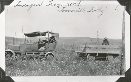
The Tolovana mining district near Livengood had a tram or railway, constructed around 1915. The line is often called the “Tolovana Tram”, although the territorial attorney general noted in 1921 that it was “a railroad in contemplation of law”.

By 1917 the line was 6 miles long, running from the sawmill at West Fork to Brooks City (“the commercial center of the district”). Brooks City merged with Livengood around 1915, but in the early 1930s it was renamed back to Livengood to avoid confusion with other places named “Brooks”. The tramway was reportedly expanded to 15 miles by 1920, reaching the head of steamboat navigation on the Tolovana river at “Trapper’s Cabin”. The line later extended to “Log Jam”, an apparently dynamic phenomenon that was variously closer or farther from Livengood as the river and its debris shifted (details and documentation of the tram’s length and route are a bit sketchy).

Initially the motive power was a homemade steam locomotive, described below:
“From West Fork to Brooks a tram was under construction, wooden rails being used. A steam locomotive of crude construction is used to haul the cars which are also of local manufacture. The locomotive was constructed by putting a 20-horsepower boiler and a 5×8 double-cylinder hoist on a flat car, the gear of the hoist being connected to the axle by sprocket and chain. The cars were constructed from native lumber, the wheels being of wood with an iron rim and flange made from sheet iron.” (From “Report of the Mine Inspector for the Territory of Alaska to the Secretary of the Interior for the Fiscal Year Ended June 30, 1916”).
A photo from gearedsteam.com shows an example of such a homemade locomotive on wooden rails (not the one from Tolovana).
An article from 1915 lists local freight haulers Jules Marion and John Wigger (aka “Moose John”) as the tram’s builders. They applied for a 14-mile right-of way between Brooks and Trapper’s Cabin in November of that year, with the tram already under construction. Another article mentions Wigger and Chris Stadleman building a portage tram at the log jam in 1915. Falcon Joslin, the Tanana Valley Railroad’s founder, was reportedly interested in the tramway as well. In 1917 Charles W. Joynt of the TVRR was appointed manager of the Tolovana Tram.
A 1920 article named O.P. Gaustad as the tram’s owner, and mentioned that he had replaced the steam engine with a 1916 Dodge automobile on flanged wheels (other articles say that C.W. Joynt brought in one or more Dodge “locomotives” around 1917, and another article states that a Dodge and an Austin were both in use by 1919). Gaustad hauled six-ton loads from the steamboat landing to Livengood, as well as logs from his sawmill along the line. Gaustad also ran the post office and grocery store, and appears to have later become a territorial senator and editor of the Fairbanks paper. One of his partners in the Livengood area was A.C. Troseth. Another person involved around 1916 was David Cascaden, who seems to have built the sawmill prior to 1916 along with Julius Hoffman, Walter G. Fisher, and Jack H. McCord.

Examples of early Dodge automobiles converted into rail cars can be found at Goldfield, NV, and in California.
At various times, several shorter trams of 700, 1,300, and 2,000 feet (probably horse-drawn) were located at “Log Jam” and at “Trapper’s Cabin”. These allowed portage of freight around parts of the river blocked by frequent log jams. A 1982 report describes a wooden-rail portage tram at a large log jam 56 miles below west fork, and reports that Trappers Cabin was 16 miles downstream from West Fork (the exact distances and extent of the main tramway vary based on the source).
One of the smaller portage trams may have been built by Al Lien, as mentioned in the Fairbanks Daily News-Miner of May 23, 1915. Another may have been built by Captain Sproul of the steamboat Martha Clow. He reportedly brought rails to “the log jam” in 1916 to build a portage tramway and haul the small steamer Livengood across for use upstream of the jam. A 1918 report mentions two portage trams around the log jam, one 1,600ft line owned by E.R. Peoples and the other of 2,200ft belonging to Marion & Thompson. A tram trip around the log jam cost $5 in 1918.
In 1924 the Livengood-Brooks tramway was sold to the Alaska Road Commission for $6,425, and the line required another $8,688.07 in repairs. Floods frequently washed away the tracks and damaged the grade. By the time the ARC took over, the line seems to have lost its last few miles from West Fork to Trapper’s Cabin, and was down to 13 miles. The Commission planned to extend the line another 12 miles to the latest “Log Jam”, eliminating two of the shorter portage tramways. The line was to be open to “Public use with gas cars”, similar to the Seward Peninsula Railroad (which was also called a tram after the road commission took it over). A survey from 1930 labels the Tolovana route as “Goverment (sic) Tramway” and describes it as 44″ wide.


The 1929 Road Commission budget allotted $20,000 in maintenance and repairs to the Tolovana line. Annual costs ran about $10,000 to $12,000. Despite the investment, some considered the line to be outdated and inconvenient. An article from 1929 described “the wooden tracked tram which winds its way over the low marshy ground”, and mentions that the track below Log Jam was “out of commission”. The article goes on to state that “The river and tram route never was practical and with the money that has been spent on it, a good road into the area could have been built”. Another article complained that the tracks were under water most of the year, and the tram could only operate for a few months each summer.
Around 1930 an old wagon trail from Olnes on the Tanana Valley Railroad was upgraded into a dirt road connecting Livengood with Fairbanks. This would later become the Elliot Highway. The complex and expensive river-and-rail route was no longer needed, and in 1931 the territorial legislature ceased operating the tramway. A bridge washout in July of that year ended public use of the line. A Fairbanks Daily News Miner article the following year advertised the remaining equipment and tracks for sale to the highest bidder.

The topo maps show a very straight “tractor trail” (possibly the tram grade) leading from Livengood past West Fork and into the flats to the South. Older topos show a “Sled Road” extending farther downstream and then cutting over towards Dunbar. A 1917 article claims that an extension of the tramway to Fairbanks was contemplated. After the planned extension to 25 miles in the 1920s, the line would have been only 30 miles from the Alaska Railroad siding at Dunbar. Recently the Alaska Railroad has considered building a Dunbar to Livengood spur, though not exactly along the route of the historic tram.
A government study mentions that “a tramway operated on the west fork of Olive Creek” near Livengood. It is not clear if this was a spur line or a completely separate tramway.
________________________________________________________
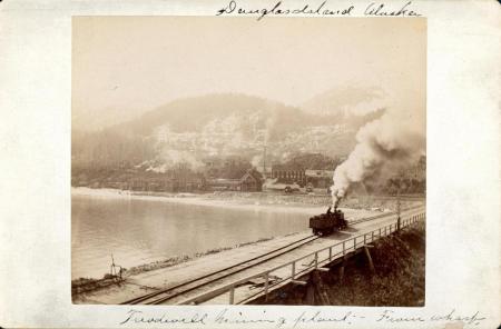
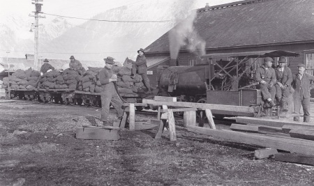
Treadwell Mines Railway.
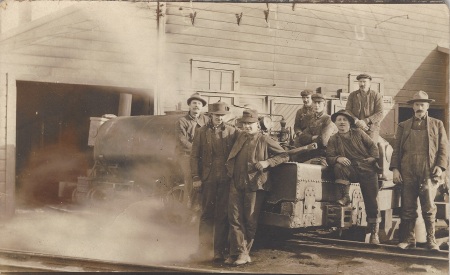
The Treadwell group of mines operated on Douglas Island across the channel from Juneau. The mines began around 1881 as a series of open pits (glory holes), and later excavated extensive tunnels below Gastineau Channel. A 25″-gauge surface railroad with several small steam locomotives ran between the mine buildings, mills, docks, and other facilities. Track also ran to the James Co sawmill in the town of Douglas and out to the powder magazine at Bullion Creek.
Around 1913 the railway began switching to electric locomotives, thanks to the cheap power made available by new dams. Underground operations initially used mules and horses to haul ore cars between the various mining faces and the central shaft. Underground tramming later used electric locomotives, although an interview with a miner described gasoline locomotives underground in 1915, with associated air-quality problems.
In 1917 most of the mine workings under Gastineau Channel collapsed and flooded. After the collapse, one mine in the Treadwell group was able to continue operations until about 1923. Most of the remaining buildings burned in 1926.
An overview of the Treadwell mine railroad in 1902:

And a more detailed look at the peak of development in 1916, prior to the cave-in which destroyed most of the mines:

The original steam locomotives were of the contractor type, typically found in construction projects Down South. A photo of one of the Treadwell locomotives, dated ca 1893, is below:

Most photos show Treadwell’s locomotives with open cabs, which seems an oddity in rainy Southeast Alaska. Order sheets mention a “removable cab for summer use”, so it is possible the engineers found it too hot to operate with an enclosed cab in the summer. The photo below shows what one of these removable cabs looked like:
Courtesy of Alaska State Library, Robert N DeArmond Photograph Collection, PCA 258-862
One of the Treadwell locomotives (also with open cab) appears in Howard Clifford’s Rails North labeled as a WP&YRR switcher. This is most likely an error, as I have not found any other mention of such a locomotive at Skagway.
Below are some remaining 25″ tracks at the Treadwell mine site in 2002. This section seems to have three rails, the extra is probably a guard rail to keep the train from derailing on a tight turn.

Another photo of one of Treadwell’s 0-4-0 steam locomotives, labeled the “Treadwell Express”:

Three of these open-cab locomotives are seen below at the machine shop at Treadwell (all have steam plumes coming from them). Two have rounded saddle tanks (likely the Baldwins) and one has a flatter tank (likely one of the 1880s units). What might be the saddle tank of a 4th locomotive is behind the ore cars:

Close-up map of the wharf and machine shop area from 1910:

More detailed and complete maps can be found below:
Treadwell surface plant and railroads in 1910
Surface map overlaid on underground workings map, 1916
After the last shaft closed, most of Treadwell’s equipment was sold to the Alaska Gastineau Mine, then inherited by the Alaska Juneau mine. At least one steam locomotive was reportedly sold to the Funter Bay Mine. Other locomotives could have migrated to nearby mines after closure, or after the advent of electric haulage. Much of the remaining equipment and metal items were sold or scrapped after the mines shut down, but a small amount of track and at least one ore car remains on-site in the woods.

Several of Treadwell’s locomotives were built by the Baldwin company. A Baldwin 0-4-0 steam locomotive was ordered in 1896. A second Baldwin to identical specifications was ordered in 1897 and built in 1898. The paint scheme was to have been olive green and aluminum. Fuel was originally to be bituminous coal, although documents and photos indicate that the locomotives were later switched to oil.
“In conjunction with the Alaska United Gold Mining Company, there was bought a new Baldwin locomotive to replace the one blown to pieces in the dynamite explosion of last spring ” (1897 Report of the Governor of Alaska to the Secretary of the Interior).
The mine suffered several dynamite accidents in the spring of 1896. In April, four tons of powder in the magazine detonated, killing a watchman . In March, a train struck dynamite lying on the track, sending pieces of the engine and cars flying through nearby houses. An early report indicated the explosive had fallen from a previous train, and claimed the blast killed a woman and child nearby. A later article said no one was killed, and blamed the accident on a local native who was injured in the blast.
Dynamite flatcar at a magazine tunnel, possibly at Treadwell:

Dynamite Trolley, c. 1916. Image courtesy of the Juneau-Douglas City Museum, 90.42.010.
The 1898 locomotive was described briefly in a North Dakota newspaper on its way to Alaska:

Both Baldwin locomotives were class 4-11 C, saddle tank engines commonly found in construction, switch yards, and industrial operations. A diagram of this type (with cab) is seen below:

A close-up of what appears to be a Baldwin locomotive with open cab is seen on the Treadwell wharf below:

Treadwell Train and Dock, c. 1916. Image courtesy of the Juneau-Douglas City Museum, 90.42.008.
Baldwin also built a compressed air or “fireless” locomotive for Treadwell in 1900. This is mentioned in the index of Erecting Drawings as index 5000A-95, Tracing # 7038. It was possibly used underground or somewhere that open flame was not desirable (such as the explosives magazine).
Example Baldwin fireless locomotive from 1900 catalog:

A 1922 publication describes 2,600 tons of ore hauled per day by compressed air locomotive at the Alaska Treadwell Mine. In addition to the Baldwin, several Rix & Firth pneumatic locomotives seem to have been owned by the Treadwell company. These were described as very small units, possibly for handling ore cars in tight side drifts where the slightly larger haul locomotives would not fit. An 1887 publication mentions a Phoenix Iron Works pneumatic locomotive shipped to Douglas Island for surface use.

Various locations in Alaska claim to have had the first railroad in the state, including Seward City (Comet), Skagway, Homer, Cordova, and Seward. While the White Pass & Yukon probably has a valid argument for the first common carrier in 1898, the following articles seem to indicate that Douglas Island had the first steam locomotive in Alaska (actually, at least the first three):
Juneau Alaska Free Press, Aug 11 1888, Page 3, Col 3: Locomotive arrived for the AM&M Co (Mexican Mine) on the steamer Ancon.
1889 Juneau Alaska Free Press: “The first railroad in Alaska” at Douglas, with another locomotive delivered that year by the steamship Geo W Elder. This may have been the same one mentioned on June 8, 1889; delivered to the Bear’s Nest Company (a mine adjacent to the Treadwell group and under the same management).
Juneau Alaska Free Press, April 13, 1889, Page 3, Column 5: Another locomotive shipped to the A. M. & M. Co on the steamship Corona. Locomotive was named “Douglas Island”.

Locomotives on Treadwell Mine wharf, circa 1885-1895. Photo courtesy of Jim Geraghty.
Another article claiming that “Douglass island”(sic) had the first railroad in Alaska came out in 1895. It does not mention the earlier locomotives delivered in 1888 and 1889.

There also seem to have been a number of compressed air locomotives at the Douglas Island mines as early as 1887.
Later sources mention electric and gasoline locomotives used at Treadwell on the surface tracks. There were also storage battery locomotives used underground. Some of the gas locomotives are listed as 30″ gauge. These could have been converted to Treadwell’s 25″ surface gauge, used in an underground haul tunnel with wider track, or used at off-site rail lines such as the Nugget Creek powerplant.
Another interesting rail vehicle seen in several Treadwell photos is a type of rail bike, aka a “velocipede” or “light inspection car” (seen at right in this photo, ridden by the man in the white boater hat). These were essentially bicycles with 4 flanged wheels. An 1898 advertisement can be seen here. A preserved museum specimen can be seen here. Another of these bikes at Treadwell is seen below. This was after electrification of the surface track, the overhead power wire is visible:

Hank Graybill, Treadwell, Alaska, c. 1917. Image courtesy of the Juneau-Douglas City Museum, 90.42.016.
A newspaper report from 1902 relates how engineer John Laughlin left his locomotive (Treadwell #1) parked at the Douglas sawmill during his dinner break, as he had done for the last 5 years without issue. On this occasion, a young man named Riley decided to take it for a joyride. The locomotive gained so much speed that Riley became frightened and leaped off, leaving the engine to crash through a coal shed and land on the beach. It was reportedly undamaged but the tender trucks were broken.
Partial locomotive roster for Treadwell Mines Railroad
(in progress):
Steam:
-1888 steam(?) locomotive. Maker unknown.
-1889 steam(?) locomotive. Maker unknown. Possibly for Bear’s Nest Mine.
-1889 steam locomotive. Maker unknown. Named “Douglas Island”. Possibly with flat-topped saddle tank.
-1896 Baldwin 0-4-0 steam locomotive. Construction No 14823. 9×12 cylinders. Named “Mexican”, tank marked “A.M.G.M. Co #1”.
-1898 Baldwin 0-4-0 steam locomotive, CN 15988. 9×12 cylinders. Tank marked “Alaska United #1”.
-??? Davenport Locomotive Works 0-4-0 (reported, no documentation found to date).
Compressed Air:
-1900 Baldwin Locomotive Works
-1887 Rix & Firth 0-4-0 (and possibly another Rix & Firth from 1889) Per John Taubeneck and mentioned here.
-1887 Phoenix Pneumatic
Electric:
-1913 GE 500V DC trolley-type, 6-ton.
-1913 GE 500V DC trolley-type, 6-ton.
-1914 Baldwin battery-type, 30″ gauge
-1914-1916 Baldwin battery-type, 25″ gauge (several units)
-1915 Westinghouse-Baldwin battery type, 4.5-ton. Marked “A.T.G.M. Co #56”.
-1915 Westinghouse-Baldwin battery type, 4.5-ton.
-1915 Westinghouse DC trolley-type, 8-ton.
Gasoline:
-1913 Whitcomb DD engine, 4-ton. 25″ gauge, #210
-1913 Whitcomb DD engine, 4-ton. 25″ gauge, #262
-1913 Whitcomb F engine, 8-ton. 30″ gauge, #278
-1914 Whitcomb F engine, 8-ton. 30″ gauge, #334
(gas locomotive information courtesy of John Taubeneck)

Treadwell Ore Train, c. 1916. Image courtesy of the Juneau-Douglas City Museum, 90.42.011.
________________________________________________________
Cook Inlet Coal Fields Railroad

“Locomotive with steel tank on flat freight car”, c. 1897-1940. Image courtesy of the Juneau-Douglas City Museum, 2009.36.098
The Cook Inlet Coal Fields Company opened a mine in 1899 at Homer, AK. From 1900-1903, one or more small steam locomotives ran on an 8.5 mile, 42″ narrow gauge track from the mines to the end of the Homer spit. This gauge (sometimes called “Cape Gauge”) was used in several railroads in Alaska. It was also used in various municipal street railways in the lower 48, and became something of a standard in American coal mines by the 1920s (ref).
The locomotive pictured above appears to be taking on water from a stream near the mining camp. The photo was found in the Juneau Douglas City Museum archives, the background scenery more closely match Kachemak Bay than any of the Juneau-area railways. Very faint lettering on the saddle tank may include the word “Inlet”. The activity pictured would also make sense for Homer. As the original center of Homer was on a sand spit several miles from the nearest stream, the homemade tank car likely transported fresh water back to town.

A 1901 court case against the Cook Inlet Coal Fields Co mentioned that “A number of the rails were old second-hand rails, to wit, had been used in street-car tracks” and that “The cars were old, discarded street-cars… trucks that they used to use in Seattle on the old horse-car lines.” (specifically mentioned is the James Street line, a 42″ gauge cable and horse trolley line which was electrified around 1899). The rails were bought from the W.D. Hoffens firm at $35/ton.
The locomotive is described as a newly-built “Port & Son” (H.K. Porter) ten-ton engine. John Taubeneck’s information lists this as Construction Number 2037, 8×14 cylinders, 0-4-0ST. Porter records state it was ordered in May of 1899 and shipped disassembled “for export”. Railroad equipment was shipped to Homer in September of 1899. The locomotive was “set up” and track laying began on June 23, 1900.

Elevation Drawing for locomotive 2037. H.K. Porter Co, ca 1899. Courtesy of Canada Science and Technology Museum.
The Cook Inlet Coal Co was incorporated under the laws of West Virginia, but was apparently based in Philadelphia. President of the company was Captain Alfred Ray, VP was Edward Anderson Ryon, and Secretary Treasurer was Clarence Eugene Lent. Other stockholders included A.N and A.S. Chandler, and W.B. Addison. Initial authorized capital was $1,650,000.
An investment article in 1901 claimed that the company had spent most of their efforts developing the railway, dock, and a sawmill, and had not yet begun to mine coal extensively. The quantity of coal was claimed to be “unlimited”. A.S. Chandler & Co of Philadelphia had taken a first mortgage of 6% gold bonds on the property. The company’s officers were described as “Philadelphia business men of high standing and means”.
Homer townsite, wharf, and railroad shops around 1904:

Public Domain photo courtesy of USGS Photographic Library
Despite the “unlimited” quantities of coal, the quality proved lower than that available from California and Washington State. While suitable for heating, the coal had only 70% of the fuel value of competing deposits, and was not efficient for the steamship market. The Russians had discovered this as early as 1856 when they attempted to use Kachemak Bay coal in their steamers.
By some accounts, the mines and railway ceased operation in 1902 or 1903, with the last loaded train left to sit for several years. On Sept 7, 1904, West Virginia creditors petitioned to have the company put into involuntary bankruptcy. An article from the Homer Tribune notes a 1905 bankruptcy sale, indicating that there were two locomotives worth $3,000. Howard Clifford also mentions a 2nd locomotive listed in the Marshall’s sale. Other property auctioned off included ten coal cars, five old street cars, and various livestock. Despite appeals by the company, the bankruptcy was upheld.
Rail cars loaded with coal at Homer are seen below. Two empty cars are in the distance.

From U.S. Geological Survey. Bulletin 277. 1906.
The railway may have seen some use after bankruptcy, as some of the investors attempted to retain control of the coal deposit. The Michigan-Alaska development company, also known as the McAlpine, Mackey, and Bushnell groups, purchased the railroad and the town of Homer in 1906 and 1907 (some of these same people seem to have been involved as early as 1900). They soon faced conspiracy charges in Federal court relating to the re-staking of claims in the area. Supposedly the new company had solicited hundreds of Detroit residents to file mining claims on their behalf, in order to side-step new Federal restrictions.
Barred from mining coal, the Michigan-Alaska syndicate began scrapping equipment in 1912. The rails were removed around 1913, and salvage firms shipped more equipment to Seattle between 1913 and 1915. Some of this salvage work resulted in further court cases. Locomotive 2037 was reportedly shipped back to Seattle by the Miller Machinery Co around 1913.
At least one newspaper article paints a picture of deliberate scandal and fraud around the operation, claiming that the entire town of Homer had been built as a sort of Potempkin village:
“BUILT FAKE TOWN TO GET PICTURES AND SELL STOCK … This company sent north, the government charges, a number of grading engines, dump cars, and street cars and built the uninhabited town of Homer, with saloons, dance halls, hotels, etc, in order that pictures might be taken for the prospectus used by sellers of stock. The machinery and other relics were brought to Seattle last week and the “town” is now entirely abandoned.” From Meriden Morning Record, 5 Dec 1913
The photo below might be one of the aforementioned pictures, showing “Downtown” Homer with loaded and empty coal cars in the foreground. Rails are also visible in the distance curving around the last several buildings.

Public Domain photo courtesy of USGS Photographic Library
A photo showing some of the rails on the dock is here.
Another photo of the railway yard is here.
A visitor to Homer in 1910 reported “roundhouses, machine-shops, engines and cars”… the fourth source to suggest multiple locomotives on the railroad. The identity and fate of any additional locomotive(s) is not known. Some of the rolling stock seen in photos is larger than that normally handled by small 0-4-0 switchers. It is possible the company owned or planned to buy a larger locomotive for regular hauling after the Porter was finished with track construction.
Other coal mines operated in the area during the late 20th century. The Cook Inlet Coal Fields Co had planned to expand their railroad to several other mines around Homer, including Moose Station and Coal Creek. In 1894 the North Pacific Mining and Transportation Company operated a tram 1/2 mile from the shore to a mine in Eastland Canyon, about 14 miles northeast of Homer. An 1892 article mentioned that the Alaska Coal Co planned to build a “tram railway” in the area that year.
Coal deposits near Homer are occasionally examined for renewed development. At least one project in the 1950s proposed to use local coal for power plants. The area also experiences occasional coal fires.
________________________________________________________
Pacific Coast Gypsum Company Railroad

Part of Pacific Coast Gypsum Co letterhead. Courtesy of Alaska State Archives, Letterhead designs etc., Alaska businesses, ca. 1890-1933, MS 43.
The mining town of Gypsum was located at Iyoukeen cove on Chichagof Island. Gypsum rock was mined from about 1902-1923 by the Pacific Coast Gypsum Co of Tacoma. A wharf extended 2,000ft into the cove and a steam railroad ran from this wharf to the shaft headframe about 1 mile inland.
Below is the first wharf in 1912, prior to its collapse. The view is looking down the incline from the ore bunkers towards the shore. The track on the right runs level alongside the incline for dockside loading:

Public Domain photo courtesy of USGS Photographic Library
Raw gypsum was shipped to the company’s reduction plant at Tacoma where it was prepared for wallboard and plaster use. The Tacoma wharf can be seen on the right in this photo.
The deposit was reportedly discovered in 1901 by a Mr. Rhinehart of Tacoma. By 1902 a bunkhouse and blacksmith shop were completed and a roadbed had been cleared from the beach to the shafts and tunnels along Gypsum Creek. President of the company was William R. Nichols, and VP was Sidney Albert Perkins. General managers at various times included J. A. Siefert and Albert G Mosier.
This railway used at least one small saddle-tank locomotive which looks a bit like the ones used at Treadwell. It is likely another contractor-type dinky. Railroad historian John Taubeneck supplied this information on the line, found in the May 1st, 1909 issue of Pacific Builder & Engineer:
Pacific Coast Gypsum
(6) 5-ton cars
(1) 12-ton Porter locomotive
Cars & locomotive furnished by Phillips, Morrison & Co. Seattle, WA
36″ gauge with 30# rail
total track 6500′
grade to cargo bunkers 2%, grade to mine 1 1/2 %
As seen in the background of the photo below, the ore bunkers were set high on the wharf to allow gravity loading of ships, and the track to the bunkers runs up a ramp or trestle from the pier. Such docks existed at several mines in Alaska, they followed the pattern of larger ore docks on the Great Lakes, but at a smaller size. A great scale model of such a small ore dock can be seen here.
Gypsum locomotive in 1918 on the second wharf:

Courtesy of Alaska State Library,Winter & Pond Photograph Collection, P87-0420.
A photo of an ore car backed up to the headframe is seen here.
A photo of gypsum being loaded into a mine cart from a stope is here.
A gypsum outcropping and cave spring can be seen here.
Some present-day views of the area are here.
Map of the railway from shaft to the beach (wharf not shown):

The railroad is described as follows in 1906:

The mine operated for two decades despite various problems, including a collapsed dock in 1912, a fire in 1918, occasional barge accidents, and ongoing issues with water. One flood in 1919 required divers to descend the shafts and secure steam pumps located underground (source). The shaft reached well below sea level, and some accounts say that the tunnels broke through into natural caves and voids in the soft gypsum. This allowed groundwater to flow in (natural sinkholes and springs nearby indicate caves in the area). In 1921 the pumps were reportedly handling a flow of 1000 gallons per minute into the mine. The operation ceased around 1923, citing a lack of easily-accessible gypsum and the expense of keeping the mine pumped out (coal was imported from Washington State to run the pumps).
After closing, a locomotive was left parked on the tracks alongside Gypsum creek. Duane Ericson located the locomotive on its side in the creekbed where the grade had washed out. More of his photos and description are here and here.

Photo courtesy of Duane Ericson, used with permission.
Interestingly, the locomotive shown above may not have been the only, or the original, locomotive used at Gypsum. Accounts vary, but one of Gypsum’s locomotives may be at the bottom of Milbanke Sound in British Columbia. The Bureau of Ocean Energy Management’s wreck tables say that 2000 tons of gypsum and “a locomotive for Tacoma” (possibly being sent out for repairs) were on board the Alaska Barge Co’s James Drummond, southbound from Gypsum, when she ran aground and sank in October of 1914. Although the crew was taken off and the barge appears partly above the water in various photos (photo 1 and photo 2), efforts to refloat it were unsuccessful and the barge was a “total loss”. This page notes that Canadian authorities would not allow American vessels to do the salvage work before the barge fully sank. However, this article claims that machinery loaded on the deck was saved, possibly including the locomotive.
Possible saddle tank locomotive as deck cargo on the James Drummond wreck:

Adam DiPietro sent me some additional photos that further support the idea of a 2nd locomotive. The one resting in Gypsum Creek appears to have slightly different
________________________________________________________
Pinta Bay / Goulding Harbor Railroad
The Pinta Bay Mining Company at Goulding Harbor operated a rail tramway about 5 miles long. This led from the shore along the Goulding River to the Cobol gold mine and mill at the base of Mine Mountain.

The mine was named after Frank Cox and George Bolyan, two of the discoverers. Other people involved with the mine were Frank’s brother Ed Cox, and Ollie Lohberg. Geographic names in this area are confusing; what is currently known as Goulding Harbor was called Pinta Bay in the 1920s, what is now called Pinta Bay was named Deep Bay at the time. Adding to the confusion, Cox and Bolyan also opened another Cobol mine and started a town named Cobol farther South on Chichagof Island around the same time period.

Arthur F. Buddington photographs, Archives and Special Collections, Consortium Library, University of Alaska Anchorage.
The railroad track was reportedly laid around 1923 by the Pinta Bay Mining Company, who leased the property from Cox and Bolyan. The USGS Mineral Resource Database refers to this line as a “5 mi. long railroad tramway”. A 1923 USGS Bulletin also refers to this line as a railroad, stating:
“A light narrow-gauge 30-inch track with 12-pound rails is being built to the mill site, which lies near the tunnel entrance 4 1/2 miles from the beach at the head of Pinta Bay… The railroad is being built to furnish a means of taking in a compressor and the mill parts… a Fordson tractor and trailers for hauling supplies on the railroad. The tractor is specially built and slung on flanged wheels.” (From Buddington, A. F. “Mineral Investigations in Southeastern Alaska” USGS 1923)
A 1949 document mentions that the property reverted to the discoverers around 1933. Cox et al did further development work and produced some gold, then apparently abandoned the property around 1936. The mill and equipment were reportedly removed from the Goulding Harbor site that year. Some prospecting continued at this location, although 1940s reports described the “light rail tramway” as broken down and unusable. The mine was restaked in 1963 and claims remained active until 1976, but no claims are listed there today.
After 1936, the rails and Fordson engine were reportedly removed and used at another nearby mine, possibly the other Cobol. The lower half of the locomotive was left behind and is still visible on the trail which follows the old grade.
“The remains of an old railroad engine are rusting away along this portion of the trail, which generally follows the lower part of an abandoned mining tramway which ran from Goulding Harbor to Mine Mountain during active mining in the 1930s” From 2006 Sitka Coastal Management Plan draft.
Fordson locomotive remains at Goulding Harbor:

Photo courtesy of Pat Roppel, taken by Jack Calvin
Fordson tractors were popular for construction of ad-hoc narrow-gauge locomotives. There was no Ford-sanctioned design, but certain manufacturers had standard conversion models available. There were also home-brew models built by small industries. The design seen in Jack Calvin’s photo resembles a Skagit Steel and Iron type that was used elsewhere, including Nome and the White Pass & Yukon Railroad. Two of the large drive wheels seems to have come off, and based on the axle and connecting rod locations, the smaller wheel with brake pad is not original to the design. Someone may have taken an axle off an ore car and stuck it under the locomotive frame for show.
Some other Fordson locomotives can be seen here. These tractors seemed to be popular with Cobol’s management, as they were used to run other equipment and were used at the second Cobol mine as well. A snippet from the 1922 Ford News notes some of their orders:

________________________________________________________
Lockanok Railroad
(I would like to thank historian Bob King for his help in polishing up this section. His Bristol Bay knowledge, and his proofreading, are greatly appreciated. John Branson of the National Park Service also provided some helpful information).
A half-mile rail line linked the Lockanok cannery on Bristol Bay’s Kvichak River to a dock on the nearby Alagnak River. It appears on topographic maps as an abandoned railroad. U.S. Survey 913 from 1912 shows a “Railroad to Cannery” from the Alagnak River, starting at the “homestead” of C.P. Hale. As mentioned elsewhere, cannerymen often used homestead claims to acquire industrial land or tie up land that could have been suitable for competitors.

Photo courtesy of Thomas Edward Clark and family.
The survey notes for this plat call the line a “narrow gauge railway on 8′ trestle” and describe its value as $200 per chain (a survey chain is 66ft long)

A Wikipedia entry on Crescent Porter Hale notes that shifting mud flats blocked access on the Kvichak to his Lockanok (or Lockenok, a corruption of the Native word Alagnak) cannery in 1912. To maintain access he staked this homestead claim and built a “short rail line” linking the cannery to the adjacent Alagnak River. The line used trains of flatcars pulled by open locomotive “speeders” powered by one or two cylinder Atlas gasoline engines.

Photo courtesy of Thomas Edward Clark and family.
Hale was general superintendent of the North Alaska Salmon Company, headed up by fellow San Franciscan Joseph Peter Haller (1856?-1915). The company owned three other canneries in Bristol Bay including the “Hallerville” (sometimes spelled “Hallersville”) cannery two miles upriver of Lockanok. A National Park Service history says the “narrow gauge railroad” connected the Lockanok and Hallerville canneries.
Survey plat showing the two cannery buildings at Lockanok:

Mud flats continued to plague both locations. In 1913 Hale abandoned Hallerville and moved its equipment to a new location on Kvichak Bay just above Naknek’s Pederson Point. After the death of Haller in 1915, Libby, McNeill, and Libby bought all the North Alaska Salmon Co’s canneries. The relocated Hallerville cannery was renamed Libbyville and operated until 1948. The Lockanok cannery operated until 1936 when the continued growth of mudflats forced it to be abandoned. The cannery burned to the ground in 1939 but the rail tracks still remain. Little remains at the original Hallerville site except a few trapper cabins.
________________________________________________________
Killisnoo Tramway
The Killisnoo herring plant on Southern Admiralty Island is shown with a multi-branched tramway on an 1891 survey and on later charts. You can see glimpses of the tracks here and here. What looks like a station platform is shown at right, below (it may simply be a boardwalk). This tram was likely horse-drawn or human-pushed, and seems to have had wooden rails. The layout suggests it was mainly to move freight between steamships and various parts of the plant.

Courtesy of the Alaska State Library, Vincent Soboleff Photograph Collection, P1-261.
More photos of the tracks on the Killisnoo wharf are shown below, including some photos of the rolling stock (small flat cars):
Killisnoo Wharf with loaded tram car.
Killisnoo Wharf in winter.
“Railroad Tracks on Wharf”.
Wharf with tram and steamship docked.
Map of Killisnoo tram tracks in 1891:

The plant originally began as a whaling station before switching to herring oil production. Many whaling stations had small railroad or tram lines, such as these in the South Atlantic.
Map of Killisnoo showing tracks in 1940 (the long wharf seems to have collapsed or been removed):

________________________________________________________
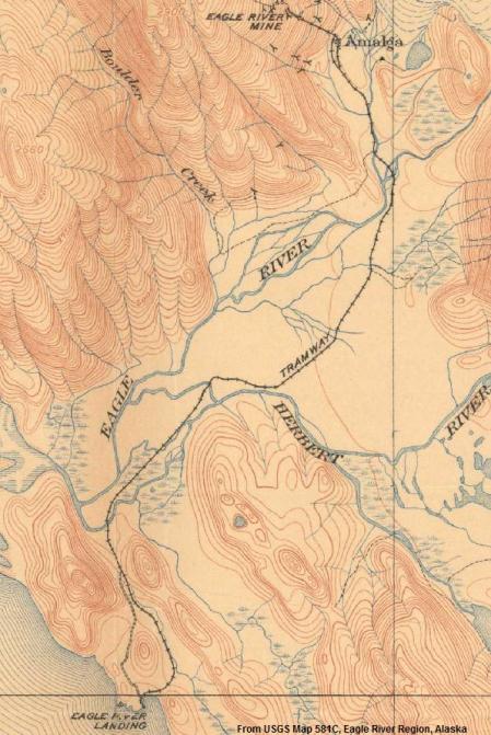
Eagle Harbor / Amalga
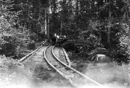
A tramway ran from Eagle Harbor to the small town of Amalga just North of Juneau, serving the Eagle River, Bessie, and Amalga gold mines. This is reported to have been “Six miles of horse tram” (some sources say seven miles) and had wooden rails as seen below. Mining began at Amalga around 1902 and the tram was probably constructed by 1903 to bring in stamp mill equipment.

Courtesy of Murry Hammond
Courtesy of the Alaska State Library, Winter & Pond Photograph Collection, P87-0510.
Town of Amalga with rails between buildings leading away towards the beach:
Courtesy of Alaska State Archives, Winter & Pond Collection, PCA 087.
A ground level view of Amalga with the tram and horses is here.
A photo showing a “Bridge on the Eagle River train line” around 1910.
1917 survey showing the terminal grounds of the tramway at Eagle Harbor, with the company’s wharf:
Some additional information on the harbor end of the tram is available here. The tramway and bridges were extensively repaired in 1915 due to flood damage. The mine closed by 1916, although some minor prospecting was done in 1933.
________________________________________________________
Dry Bay Railroad

A short railroad was begun in 1909 or 1910 at Dry Bay by the St. Elias Packing Co. This company opened a cannery at the mouth of the Alsek River, and built the rail line to link the cannery to a nearby pier. This operation was closely tied to the Yakutat & Southern Railroad, and was at times technically part of the Y&SRR despite not being connected by rail. Construction continued through 1911, when a US Bureau of Fisheries report lists 21 men employed as “Railway Construction Gang”.

The cannery was built near a prior saltery operation of the Alsek Fisheries Co, which began in 1907 under Capt. Malcolm Campbell and T.E.P. Keegan, and ran until 1910. Campbell was reportedly still active in the area in 1913, running a mild-cure operation from the schooner Standard Fish Co No 2. He also skippered several cannery boats in the intervening years.

Topo maps show the railroad grade from the cannery to deep water about 1.5 miles away. A 1919 survey shows the line reaching just over 2 miles, with a trestle across a branch of Dry Bay to an island which no longer exists. Shifting tide flats constantly changed the layout of this area, causing ongoing trouble for vessels and structures.
The owner/manager of the cannery in 1911 was listed as R. A. Leonard, formerly of the Columbia Canning Co of Haines. He is also listed as the master of the 103′ wooden ship Oakland which sank at Dry Bay in October of 1912 (all crew were rescued, but the ship and cargo were lost). Captain Malcolm Campbell had also skippered the Oakland for Leonard.
Leonard’s Dry Bay cannery was purchased by Gorman and Company prior to 1912, (they are listed as the home office of the company in 1911, and bought the Y&SRR around the same time). The cannery reportedly closed in 1913. The property was purchased by Libby, McNeil and Libby in 1916 (again, this company also bought the Y&SRR). Fish were apparently still bought to the Dry Bay wharf but were then taken to Yakutat for processing, the Dry Bay cannery being used only for storage. A 1925 memo from the US Dept. of the Interior states that the railroad was not operated after Libby, McNeil & Libby acquired it.
In 1919, the Yakutat & Southern Railway filed a route survey covering the Dry Bay cannery, showing the existing line from wharf to cannery, plus a branch leading towards the Ustay River. This was referred to as “The Dry Bay Extension of the Ustay Division of the Yakutat And Southern Railway”.

It is not clear how far towards the Ustay River this line reached. Surveys show a planned terminal about 5 miles NW of the cannery on the Ustay River. Local information reports a grade leading NW from the cannery site, and aerial photos show what could be a railroad grade reaching the ocean outlet of the Akwe River (also spelled “Akquay” in 1910). Local reports indicate there was some construction in the direction of Yakutat from the cannery. As early as 1901 the Y&SRR had planned to lay track from Yakutat to Dry Bay, serving canneries and fish buying stations at each river along the way. The cost of bridges was found prohibitive and the main line from Yakutat never reached farther than the Situk River. At some point the Ustay River appears to have shifted its course from West to East, leaving the terminal site landlocked.

From Hubbel, Charles S. “Map of the Ustay Division, Yakutat & Southern Railroad” 1919. Courtesy of Alaska State Archives, George Danner Map Collection, MS 262
Rails North shows a Y&SRR locomotive that looks like an 0-4-2 Porter (mislabeled as a Heisler in the first edition of the book) which is probably the one from Dry Bay. The date is listed as 1907, so the Porter was likely at Yakutat before moving to Dry Bay.

Public domain photo courtesy of Wikimedia Commons.
A 1966 article in The Trainmaster comments that “there must have been an earlier loco” on the Y&SRR, “Something must have powered the road from its incorp in 1903 until the #2 was bought new in 1907” (Y&SRR #2 was a Lima 2-6-2 steam locomotive, a Heisler “#1” was acquired around 1904 but was reportedly in poor condition and did not meet the line’s needs, later being converted to diesel). Likely the first “#1” mystery locomotive used at Yakutat from 1903-1907 was the Porter 0-4-2. The gauge of the Dry Bay line is uncertain, track from Yakutat to Situk was most recently standard-gauge, but could have begun as narrow gauge. Photos from around 1914 appear to show dual-gauge track (both narrow and standard) on the Yakutat cannery dock. A 1992 study described the Dry Bay cannery line as narrow gauge.
The Porter could have been surplus from Y&SRR president Fred Stimson’s family business, a logging company in Washington state which owned several locomotives. Stimson’s father T.D. Stimson also owned a lumber company in Michigan and used several 15-ton Porter locomotives. One, named “Little T.D.” was C/N 665 built in 1885, and another named “James Roe” was CN 524 built in 1882. Both match the design seen at Dry Bay (0-4-2 with rear wood bunker and sliding doors), but both were narrow gauge. The Stimson railroad in Washington State was standard gauge.
The Y&SRR’s application for right of way at Dry Bay seems to have met with some opposition from the government. In 1925, the Department of the Interior threatened to rescind public land grants because “The railroad is almost wholly a plant facility of the canneries”, and “does not engage in transportation for the public”. The memo accused the railroad of exploiting the law for the benefit of a private corporation, and gave them notice that permission to use National Forest land would be withdrawn. After several appeals and extensions, the issue seems to have been settled, as the Dry Bay route was approved in 1932 with the company proposing to act as a common carrier.
This book mentions that the Dry Bay railroad was abandoned after an earthquake in 1937 (the sandbars probably shifted to block or damage the wharf). The locomotive was left in-place. This photo shows the abandoned locomotive at Dry Bay. This photo shows some of the tracks.
Pat Roppel provided the following information about this railroad:
-In 1912 the Y&SRR proposed a 50-mile right of way to Dry Bay
-In 1913 timber was cut at Dry Bay for a tram road, but the company went bankrupt the next year.
-In 1916 the track, rails, cars, and a locomotive at Dry Bay were sold (back) to the Y&SRR.
-In 1946 the Y&SRR held a Forest Service special use permit for a 50-mile right of way to Dry Bay.
________________________________________________________
Nugget Creek Tramway
In 1911 the Treadwell mine began constructing a power plant near Mendenhall Glacier in Juneau. This involved damming Nugget Creek, drilling a 650ft tunnel to tap the creek, and running a pipeline from the tunnel to a hydroelectric plant near the present-day glacier visitor’s center.

Photo courtesy of Bill Binns, used with permission.
Rails ran from the road and construction staging area, past the power house, and up to the tunnel. Cars were pulled up the steep grade to the tunnel by an electric winch (I’m not sure what drove them on the level sections of the line).

Courtesy of the Alaska State Library, Alaska Road Commission Photograph Collection, P61-085-155.
Until a few years ago, you could still find some of the machinery and generators on their foundations in the woods. Many of the remains have been demolished by the city in an effort to limit liability.
Juneau Empire writeup of the Nugget Creek power plant.
Another Empire write-up.
A photo showing the drop to the steep section of tramway, with Mendenhall Glacier in the background.
Another photo shows one of the cars, a wagon with large flanged wheels:

Flatcar and Work Crew , c. 1910. Image courtesy of the Juneau-Douglas City Museum, 97.10.013.
And this photo shows the tram at the tunnel entrance, with what is probably Mendenhall Glacier in the background. Several women are standing around the track (apparently a plank tram here), with an ore car behind them:

Women in Tunnel Entrance, c. 1912. Image courtesy of the Juneau-Douglas City Museum, 97.10.025.
Juneau historian Brian Weed has a modern view out of the same tunnel here.
Photo of tramway passing power plant.
Another photo of the tramway passing the plant.
Some contributed photos of Mendenhall tramway remnants:
Remaining tracks:

A rail car in the woods, it appears to be a typical ore cart:

Rail truck:

Hoist for the inclined section of the tram:

________________________________________________________
Fortmann Hatchery Tram
The Alaska Packers Association’s Fortmann Hatchery near Loring, AK had a “tramway several miles long” . The last photo on this page shows the tram, which appears to be a wooden plank road. The line is labeled as a “Tram Road” on one survey and as a tramway on another. Cars were likely pushed by hand or possibly pulled by horses. This may not have been a single stretch of track, or even a single type or gauge of track, but rather multiple tramways portaging between lakes. A publication from 1904 describes the following route to reach the hatchery:
“…Up Naha River one-fourth mile to Smokehouse Tramway, on Tramway 1 1/2 miles to Jordan Lake, across Jordan Lake one mile to Windlass Tramway, on Tramway three-fourths mile to Heckman Lake, across Heckman Lake two miles to hatchery at head of lake, on Naha River”
This photo shows what appears to be a rail cart in the background (on the left). I am not sure if this is at the cannery or the hatchery. In addition to the two tramways mentioned in 1904, there are several tramways shown on survey plats of the hatchery complex:

A report from 1904 mentions a tramway 5,524′ long built to move materials for a pipeline from a spring to the cannery. The project apparently included 2,000ft of trestle and a tunnel between Patching and Heckman lakes.
Below are a few more photos of the tramway. So far I have not found any pictures of remaining rolling stock, modern-day portaging seems to require people to drag their boats along the planks of the route.
“Naha railway” upper end
Canoe on tramway
Salt water end of tram, leading into water
Hauling a larger skiff onto the tramway
Tramway alongside river
________________________________________________________
Pribilof Island Trams
Saint Paul Island seems to have had a tramway as early as 1898, when the Alaska Commercial Company introduced “a moveable railway track placed on the beach, extending into deep water, so that boats come to and discharge their freight into cars to be hauled on shore”. This may have been akin to Decauville track, something similar was also used at the A. C. Co’s coal depot at Unalaska.

Boat landing at St. Paul, from Record Group 22 of the US Fish & Wildlife Service. https://catalog.archives.gov/id/23854005
St. Paul and St. George islands had more permanent tramways installed by the US Navy around 1911-1912. These supported construction and supply of radio stations, including hauling fuel drums for generators. The lines ran from the wharf to the radio station on St. George, and to various points in the village of St. Paul. The layout at St. Paul suggests the Navy tramway also supported seal harvests, as it ran to the salt houses and government warehouses.

Track through warehouse from wharf at top right, with small flatcar at bottom center. Image courtesy of NOAA
This map from 1915 shows tracks leading to various buildings in the village of Saint Paul. A 1917 map labels this as “Railway Track (2ft Gauge)”. A similar map for St. George Island shows the tramway there, of a simpler design (a straight shot from warehouse to radio station with a branch to the wharf). It appears to be labeled “RR Track (2ft Gauge)”
Patrick Durand and Dick Morris with the Engine 557 Restoration Company were kind enough to send me a 1917 map of the Naval Radio Station and tramway. I’ve traced the track in red to highlight it in the copy below. This map omits the spur to the cold storage near the wharf, which could have been added later in 1917.

More photos of St Paul village showing the Navy tramway are available below:
Tram tracks in background
Tracks past boats and bags near wharf
Tracks leading towards radio station
Tracks in 1940 being used to store barrels (middle of photo, wooden ramps seem to be unrelated).
Photo showing “Machine Shop Railroad” on St. Paul Island:
Other tramways reportedly supported seal harvests (both islands were government-controlled sealing operations for many decades). The tracks may have run from the rookeries to the main port or village area. One or both of these may have actually been a plank road, as seen here. Here is another photo of the plank road on St. George. One report called for construction of a 12-mile tramway powered by a gasoline engine on St. Paul Island. A Bureau of Fisheries report from 1922 describes wooden tracks for trucks and tractors “over the worst stretches of sand”, and also mentions that heavy seas destroyed the St. George wharf tramway in 1921.
________________________________________________________
Chickaloon Tram
A photo in the Alaska Digital archives shows an incline tram “connecting old and new Chickaloon” in 1921. Another view is here. This was likely associated with the coal mines in the area. The Alaska Railroad had a spur to the region that was abandoned in the 1930s.
Patrick Durand reports that Old Chickaloon was on the river bottom and had the railroad terminus. New Chickaloon was built at the top of the hill by the Navy, the coal mines were developed as a fuel source for the Navy’s North Pacific Fleet. The incline tram moved materials from track side to the new town site. The buildings and track were mostly removed by 1928.
________________________________________________________
Sitka Pulp Mill Rail Yard
In recent times, several Alaskan port cities have had stub rail yards with only barge access in or out (Such as CN’s Aquatrain). This theoretically allowed more efficient bulk transport, as entire train cars of product could be shipped to and from the state without repackaging. Rail barges are also used between the Alaska Railroad and Outside lines (One of the stranger imports is Lower-48 graffiti, the spraypaint “art” on rail cars from Down South is usually much high quality than local Alaskan taggers can manage).
Sitka had a rail yard at the Alaska Pulp Corporation’s mill in Silver Bay. Cars of chemicals were brought in, and cars of pulp products taken out. At least one diesel switcher stayed on-site. John Taubeneck reports that the mill had a 400hp, 65ton GE center cab locomotive built in 1943 for the US Navy, which was transferred to Cleveland Ohio after the mill closed. The Sitka mill shut down in 1993 and the site was donated to the City in 1999. Most of the rail yard has probably been ripped out during ongoing demolition and redevelopment of the site.
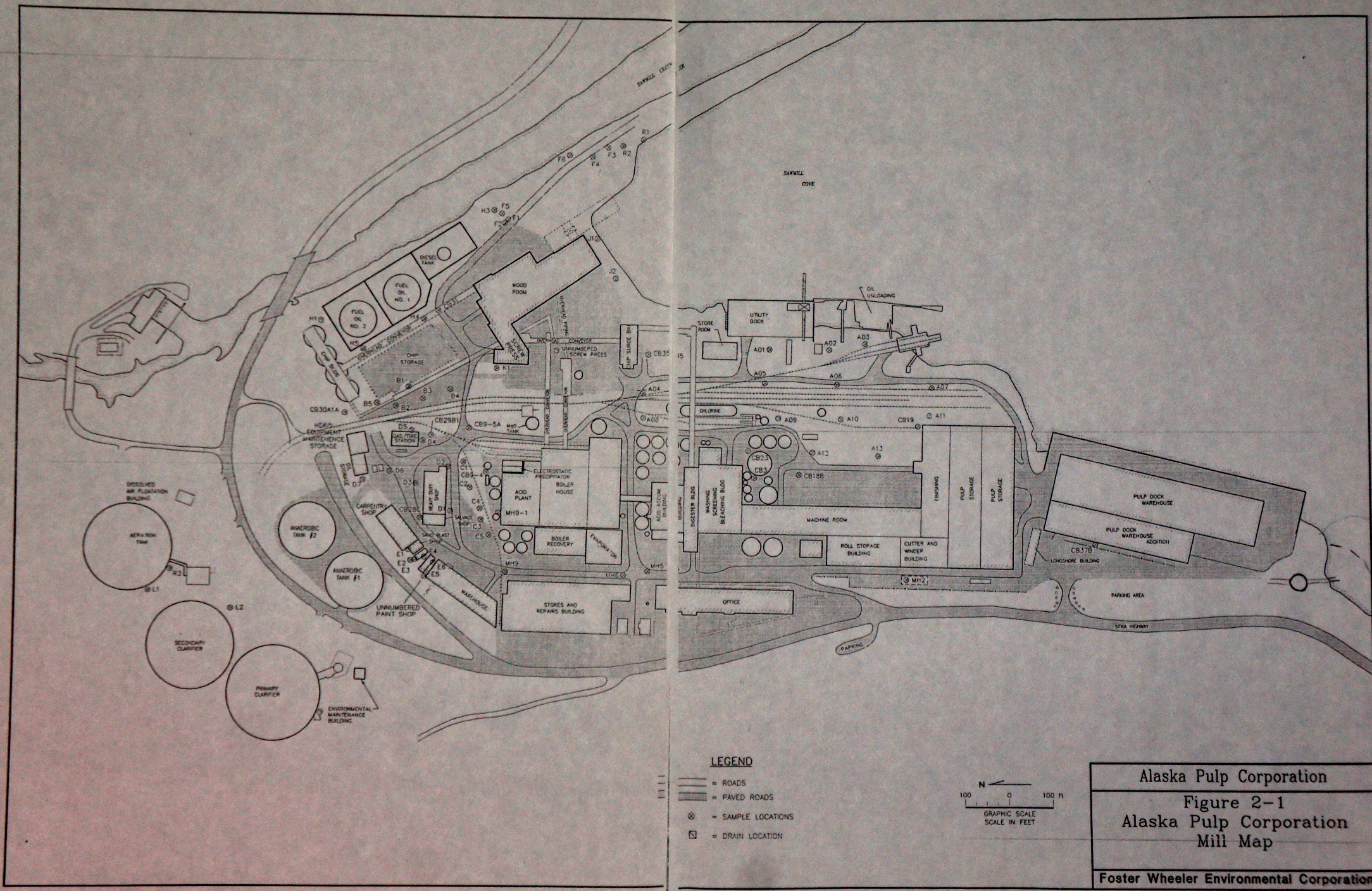
Incidentally, the hydroelectric dam and power tunnel built for this pulp mill also involved a small construction or mining tramway, seen in a 1958 newspaper photo. This seems to have been mostly underground for mucking out the headrace tunnel, as with other Alaska hydro projects. The tracks and cars probably belonged to a contractor and were removed after completion.
________________________________________________________
Ward’s Cove Rail Yard
Like the pulp mill at Sitka, the Ketchikan Pulp Co had a yard and rail barge dock at the Ward’s Cove mill. At least two switch engines operated there, including a 50-ton Whitcomb B-B diesel center-cab, #61279. Some photos and information are available here.

________________________________________________________
Valdez Railroads

While mentioned in several other publications, few books fully cover the four(!) different railroads which have laid track in the town of Valdez. These include the Copper River & Northwestern, the Valdez Yukon RR, the Alaska Home RR, and even the Alaska Railroad.
Several abandoned railroad projects at Valdez have left their mark in cuttings and tunnels around town. The closest to being realized was the Alaska Home Railway, which purported to be constructing an electric line to Fairbanks. The company brought in at least one steam locomotive and laid a mile of track, but turned out to be largely fraudulent. Another company was the Valdez-Yukon Railway, who graded 10 miles, laid some track, and brought in some rolling stock. They supposedly owned a large locomotive but never shipped it to Alaska. The Copper River and Northwestern RR also started grading work at Valdez prior to 1909, but abandoned the area in favor of Cordova. This company dug a tunnel and laid some narrow-gauge track, but may not have advanced to putting down standard-gauge rails. After rival railroad crews had a shootout in nearby Keystone Canyon, all work was abandoned. The town of Valdez was left nearly bankrupt after investing heavily in various railroad scams.
Alaska Home Railway operating their steam locomotive.
Valdez Yukon work car.
Valdez-Yukon “Roundhouse”
Valdez-Yukon wharf and flatcars.
Copper River Nothwestern Tunnel and rails.
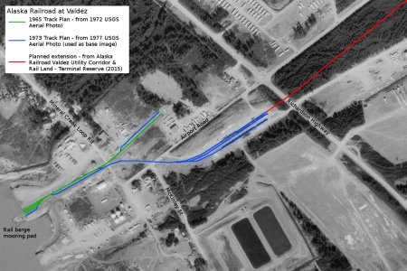
Valdez had another rail-barge port and short industrial line. This was technically part of the Alaska Railroad. It was originally installed around 1965 to aid in rebuilding Valdez after the 1964 earthquake (source). The yard was expanded in 1973 for pipeline construction. This port does not seem to have had an adjustable rail bridge, barges were beached on a pad and allowed to go dry at low tide, when the decks would line up with the railroad grade on shore.
During the Trans-Alaska pipeline boom, a rather odd logistical situation developed. Pipe sections were apparently brought to Whittier on flatcars by Hydro-Train, back-loaded onto smaller barges, taken to Valdez to be connected at a welding plant, then shipped back to Whittier for transport North. The road out of Valdez could not handle the longer pipes, and Whittier had so little flat land that there was no space for a welding plant. This complex dance of pipes likely could have been avoided by simply doing the welding in Anchorage or elsewhere on the Alaska Railroad mainline. It appears to be one of those very Alaskan schemes designed to squeeze extra money out of unsuspecting investors “Down South”.
More photos are here. Some additional details are here.
The tracks seem to have been removed after the pipeline boom, although the Alaska Railroad still owns a terminal reserve at Valdez, with right-of way extending past the 1970s rail yard towards the airport.
US Survey Plat 439, based on 1909 surveys, showing multiple railroad grades at Valdez.
________________________________________________________
Saxman Rail Barge Terminal
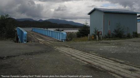
Saxman, a suburb of Ketchikan, had a small rail barge terminal and curving track with at least one siding at the Saxman Seaport. It was built around 1967 (another site says 1964) to be a container port for the Ketchikan area. Motive power was apparently something like a trackmobile. In 1977 the site was known as the Ketchikan and Northern Terminal, and handled 25% of Southeast Alaska’s total freight. About 4,000 tons of propane were brought in each year in 60 rail cars (source). The site looks somewhat derelict in recent aerial and ground photos, and the rail ramp is listed as a “dynamite loading dock“. A government study from 2012 proposes to pave over the tracks and use the site for container unloading.
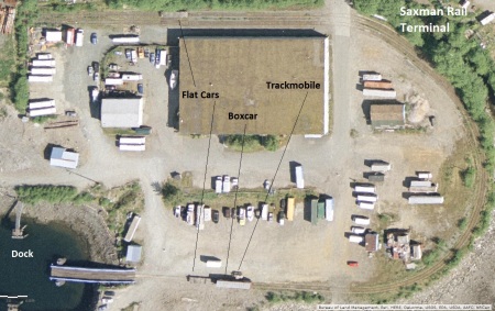
More recent aerial photos (2022) show the rails mostly buried under dirt, and the barge ramp replaced with a small boat dock.
________________________________________________________
Trans-Alaska Railroad / Alaska Short Line Railroad
Howard Clifford reported that work began in the early 1900s on a railroad between Williamsport at Iliamna Bay and Railroad City on the Yukon River near Holy Cross. Supposedly this progressed to the point of laying some track in the area of Old Iliamna and blasting at least part of a tunnel (probably through the Chigmit Mountains). A Fairbanks Daily News-Miner article also mentions track laid at both ends of the line, and Bob DeArmond mentions that steel rails were shipped to Illiamna Bay around 1904. Another shipment of rails was lost when the steamer Farallon was shipwrecked in Illiamna Bay in 1910.
Evidence of an overgrown railroad grade can be seen South of the present day Williamsport – Pile Bay Road.

This line seems to have had several names and backers. The Trans-Alaska Co laid out a trail along the route in 1902, but then folded. Several sources such as this and this indicate that they planned or began a horse tramway from Iliamna to St. Michael, with roadhouses every 25-30 miles. This seems like an excessive distance for a horse tram.
The Alaska Short Line Co took over the project soon afterward, running surveys from 1903-1908. A 1906 journal describes the route as “Iliamna Bay or Kamishak Bay to Anvik”, with Joseph Taylor Cornforth as president and W.E. Smith as chief engineer of the Alaska Development & Construction Company. Cornforth was apparently involved with all of these companies, as well as a steamship line proposed to serve Iliamna Bay in 1902.
Railroad City originated as a horse camp for surveyors around 1901, with the Alaska Shortline Railway and Navigation Co planning to develop agriculture in the Yukon River Valley. The company later decided that the railroad should be located along a different route and abandoned the town (source). Clifford reports that some of the equipment still remains in place at both of these ghost towns. Railroad City was renamed Red Wing for a time and operated as a transshipment point by the Northern Commercial Company for freight to Iditarod and Flat. The Standard Oil Co also had tanks and a fueling station at Railroad City in the 1930s. A survey from the 1980s mentions “numerous dilapidated cabins” at the site.
In 1910 the Alaska Short Line Railway and Navigation Co requested more time from Congress to prove up their right-of-way claims, as they had not been able to start construction. A 1910 journal noted that the right of way was acquired that year by a syndicate headed by A. J. (Arnold) Schuer. The News-Miner also mentions a “Free Love Society” as being involved. This book describes one of the planned routes, and notes that a branch to Bristol Bay was considered to serve canneries in the area.
________________________________________________________
Rush & Brown Mine Railroad
Located on Prince of Wales Island, this copper-nickel mine had a railway leading about 3 miles to a deep-water wharf. A freighter at the wharf can be seen here. The mine used a Porter 0-4-2 locomotive with rear tank to haul ore trains.

The Rush and Brown mine was discovered around 1904 (some sources say 1900) by U. S. Rush and George E. Brown, and operated from about 1906 to 1923 under the Alaska Copper Company. A note in the March 2, 1906 issue of the San Francisco Call states that:
“The forest service has granted to the Alaska Copper Company the right of way for the construction of a narrow-gauge locomotive tramway within the Alexander Archipelago forest reserve, Alaska”. (San Francisco Call, Vol 99, No 92, pg. 2, 2 March 1906).
Despite being a consistent producer and operating for many years, the mine did not have a very large output. It used lower-cost methods of excavating and was generally known for being frugal. Workings included underground tunnels and shafts, as well as a large open pit “glory hole”. The Alaska Copper Co built their own smelter at Coppermount on the other side of Prince of Wales Island, but this was unable to withstand price fluctuations in 1907 and closed, as did the other major smelter at Hadley. The Rush & Brown mine closed in 1923 due to low copper prices and difficulty securing a smelting contract.
The Solar Development Co optioned the property in 1929, pumped out the workings, and began a new adit, but no major work appears to have been done after that. A 1937 report states that “The railway, which is 42 inch gauge, 16lb. rails will require a considerable expenditure of money although light loads approximating 2000lbs were taken over it during the last summer and fall.” By 1948, the railway was reported “completely deteriorated, except that 2 miles of 16-lb rails remain”.

In Fortunes from the Earth, historian Pat Roppel describes the locomotive as an 8-ton H.K. Porter, hauling steel cars of 50-ton capacity. The locomotive was recovered in the 1970s and is partway through restoration.
According to steamlocomotive.com, the Rush & Brown locomotive came from the Albany (Oregon) Street Railway, and was a former steam dummy (construction number 1392). This street railway operated from 1889-1918. It originally used horses, then acquired a newly-built steam dummy engine (named “Goltra Park”) in 1892. The steam dummy broke down in 1900 and was abandoned (one source says the cab burned off). Another H.K. Porter locomotive with a normal cab was purchased in 1903 and used until 1908 when electric locomotives took over. The gauge is listed as 3’6″, or 42″. Albany’s steam dummy is seen here, and the normal-cab Porter is shown here. Both appear to be 0-4-2 locomotives, but the regular-cab Porter looks more like the locomotive which came from Rush and Brown. A post on this forum states that the steam dummy was salvaged and converted to a normal cab after Albany abandoned it.
The Rush and Brown later combined some operations with the nearby Salt Chuck Mine. Patricia Roppel reports that ore was brought from Rush and Brown to Salt Chuck using a Mancha storage battery locomotive, which can still be found near the Salt Chuck mill site.
________________________________________________________
New Boston Mine.
The New Boston Mine on Douglas Island had a 2,800-foot long tramway around 1887, from the mine to a wharf on Gastineau Channel. The mine was not productive, and in 1889 the rails from the tram were moved to the Douglas sawmill. (Per Bureau of Mines Mineral Investigations in the Juneau Mining District, Alaska, 1984-1988). The sawmill was connected by rail to the Treadwell mine, the equipment could have been re-used on that line or used for hauling logs out of the water.
________________________________________________________
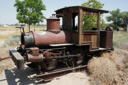
Peterson Mine & Pearl Harbor Tram
The Peterson Mine (started around 1897) had a 4-mile horse-drawn tramway to Pearl Harbor, north of Juneau. The route is now a public hiking trail and remnants of the wooden tram (with metal straps to guide cars) are still visible. The tram was reportedly built around 1903 by Tom Drew. One government report said that mules pulled 1.5-ton cars, and that steep grades prohibited heavier loads.
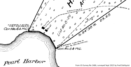
Photo of tramway rails
Photo showing metal strap rails on wood tramway.
Slideshow with more photos of the trail and tram remnants.
Rails at Pearl Harbor (this could be a marine railway).
A rail cart found nearby, possibly from this tramway.

The mine was founded by John Peterson, and operated by his entire family. When John died in 1916, his wife Marie and their two daughters continued to operate the mine, doing everything from the drilling and blasting to blacksmithing and tramming. A mine run by three women was somewhat unique at the time, but Alaskan women tend to do well in unconventional activities. More information is in part one and part two of a 2011 Juneau Empire article.
________________________________________________________
Penn Alaska Tram
A short tramway with two stations is shown at the Penn Alaska mine on Taku Inlet. This mine dates from around 1906. Other documents show slightly different alignments for the track, with at least one showing the “road” as another branch of the tram. A report from 1911 describes this as “wood rail tramway”.

________________________________________________________
Crystal & Friday Tramway
A tramway (or “tramline”) with several branches ran between various mines in the Snettisham area (the historic town, not the present hydropower station). One branch connected the Crystal Mine to the Friday Mine’s stamp mill. The tram routes are marked as trails on modern topo maps.

The tramways are labeled as “roads” on an 1899 survey, but are depicted with the crosshatches normally used for rail lines. They may have been elevated tramroads with wooden rails.

Gold deposits at both mines were largely exhausted by 1905, with the equipment reportedly removed soon afterwards. Some work continued until the 1920s. Development in this area is currently under review, with a proposal for an iron/titanium mine. The iron ore content of this hillside is so high that navigational charts note a severe magnetic disturbance to compass bearings for passing ships.
________________________________________________________
Rodman Bay Railroad

Rodman Bay is located on the North side of Baranof Island, in Peril Strait. From about 1901 to 1904, a railroad ran from the shore to a gold mine on nearby Rodman Creek. The line was approximately 8-10 miles in length. The mine failed after only a few years, by some accounts the deposit was poorer than expected, and by other accounts the entire thing was an investment scam.
The railroad was 30″ gauge and used an H.K. Porter 0-4-4T (or “Forney”) locomotive named “Rodman”. The engine was construction number 2245, built in the fall of 1901 as Engine #1 for the company. This was a slightly larger and more complex engine than typically seen on small Alaska mining railways. It may have been picked up cheaply after an earlier order fell through, as the Porter specification sheet indicates it was originally for the Ray Copper Mines Co of Riverside, AZ. On the sheets, the original order details are crossed out and replaced with the Rodman Bay info. The original Arizona design included a wood-burning stack, but the fuel was changed to coal for use in Alaska. The engine was to be marked:
RODMAN
THE RODMAN BAY CO.
LIMITED
1
Rolling stock is described as five large and three small flat cars, one hand car, one velocipede (a kind of railroad bicycle), and two ore carts.
A Porter 0-4-4T of similar size can be seen here. Pioneer Park in Fairbanks has a replica of an 0-4-4T Porter. A nearly identical design based on Porter’s 1908 catalog is seen below:

Below are a few more historic images of the railroad:
Lumber for mill on flat cars, ca 1900
Trestle and Workers at Rodman Bay, ca 1900.
Railroad Bridge at Rodman Bay, ca 1900.
Tracks along the beach, ca 1900
Boarding house, engine house, and railway tracks.
Sawmill and buildings, railroad visible on right. 1902.
Approximate route of the Rodman Bay Railroad:

Mining claims were located in the area around 1898 by a group of prospectors, including brothers George and James Bent. They were initially financed (or “grubstaked”) by the Alaska-Baranof Exploration Company, incorporated “to build and operate railroads”. Backers included Juneau banker W. T. Summers and Pacific Coast Steamship Co captain James Carroll. Other investors were brought in around 1899, and the company became known as the “Rodman Syndicate”. In 1900, after initial mill tests of local ore proved promising, the syndicate re-organized as the Rodman Bay Company.
Company directors included George B. Hudson, Edmund Rawson, and H. G. Slade. A major investor was Colonel Edward Harrison Power. Colonel Power reportedly won a large amount of money from various casinos, and invested it into the “Alaskan Rodman Bay Railroad”. He was also involved with several street car companies in the US.
A 1901 survey shows the railroad leading from the wharf towards the mine, across mining claims named after company officials:

The company began large-scale development of the property in 1901, under the local management of George Bent. A very large tunnel was begun, dimensions are given as 10ft high by 12 feet wide, and about 760ft long. An additional tunnel and shaft were started near the wharf. The stamp mill was planned to have 120 stamps, but only 60 could be delivered by 1902. This publication describes multiple worker’s houses, a bunkhouse for 52 men, an office, a large sawmill, a general store, a stable for 6 horses, a blacksmith shop, storage buildings, compressor, and a roundhouse and water tank for the railroad. The company kept cattle, sheep, and chickens at nearby Appleton Cove to help feed the workers. A post office opened in 1901 and received two mail deliveries per month. The company owned the steamer Tonquin for a few years. Newspaper articles claimed the mine would outdo Treadwell in profits, but this claim was made of almost any new mine in an effort to attract investors.
The railroad grade was largely finished by late 1901, but only a few miles of rail and probably a few hand or horse cars were initially available. The remainder of the material was likely delivered in March of 1902 when the steamer Al-Ki dropped off 600 tons of freight at the Rodman wharf. Chicago supplier Allis-Chalmers provided the stamp mill and other equipment, and procured the locomotive from the H.K. Porter Co. on behalf of the Rodman Bay Company. By September of 1902 an article reported the railway in full operation, with one locomotive “of the very latest pattern”.
The track was laid almost entirely on trestles, an average of 5-7ft off the ground. This was a typical roadbed for Southeast Alaska, easing snow removal and allowing crossing of rough or swampy terrain. It was initially cheaper and faster to build than a gravel grade, but would have needed regular maintenance. Outside newspapers did not think much of such grades, describing Rodman Bay’s line thus:
“The railroad, while a very expensive piece of work, is only a temporary construction, and is probably as unsafe a bit of railway as could be found in the world. Although fifty men have to go over it twice each day to their work, the company has posted notice that it will not be responsible for men injured or killed on the road” (From “The Butte Inter Mountain”, 29 Oct 1902).
The company probably intended to extend the track to Peril Strait, to supplement the wharf at Rodman Bay. A 1901 note in Mining and Scientific Press claims the track would run “to the channel… for the purpose of being able to ship from and to the mine during the winter when the bay sometimes freezes”.
The mine seems to have run out of funds around 1903 without finding the promised rich ore. By 1904 it was reported that the developers had been overly optimistic, and the mine was not returning on the investment. After incurring expenses in the range of $750,000, the property slid into receivership. Some authors speculated that the whole thing was a fraud to sell stock, as several other mines in the state had been. Management and investors squabbled over who was to blame, with several lawsuits filed. Refinancing was attempted in 1905, but by 1906 the post office had closed and by 1907 only a single watchman remained on site.
Some of the machinery was apparently removed in 1904. The dock collapsed in 1907 and the watchman complained that $50,000 worth of equipment was being left to decay in the elements. The company was dissolved in 1908 and its holdings were to be liquidated, but it was reportedly difficult to dispose of the surplus items (likely due to the collapsed dock). Historian Robert DeArmond believes that the locomotive, rolling stock, and track were sold to a copper mine on Prince of Wales Island, he does not know which one. The liquidator reported all the company property disposed of by 1921, although some reports indicated that much was left in the woods still in crates. By that date the buildings were reported to be in ruins.
A story from a hunter mentions the “Old Railroad” at Rodman Bay in this book, and implies some track was still in place. A 1907 visit reported a railroad at the “nearly deserted mining camp”. Another visit from 1909 also mentions the “tramline” in place. Photos from a fishing party in 1909 show the group using the velocipede on the railroad:

Courtesy of Alaska State Archives, Flamen Ball Photograph Collection, PCA 024-67
Rodman Bay had timber harvest activity for many years, with a logging camp located in the bay. Logging roads and clearcuts have likely destroyed the former railroad grade and any remaining artifacts.
________________________________________________________
Lucky Chance Mine
Located in Silver Bay near Sitka, the Lucky Chance mine reportedly had a 3-mile tram from the mill to the beach around 1901. The mine itself was about 5 miles inland, and connected to the stamp mill by a 4000ft aerial tram. The track to the beach was likely a horse-drawn tramway with wooden rails. Mines in this area were some of the earliest lode-gold workings in Alaska, dating back to 1872.
________________________________________________________
Sumdum Railroad
A rail line about 2 miles long led from Sanford Cove in Endicott Arm of Holkham Bay, to the Sumdum Chief and Bald Eagle mines. Wooden track was in place with horsedrawn carts sometime before 1896, and a small steam locomotive seems to have been used sometime between 1896 and 1903.

Photo from Bob DeArmond collection, courtesy of Pat Roppel
Although the Sumdum mining area was one of the earliest developed (beginning in 1869) and one of the more profitable developers (the Sumdum Chief was the largest mine in the Southern Juneau gold belt), its early decline has left scanty information available.
In a 1971 issue of the Alaska Journal, historian Patricia Roppel notes that a small locomotive was used at the Sumdum Chief Mine, owned by the Alaska Sumdum Gold Mining Company. The photo above accompanies the article, showing a small saddle tank locomotive (possibly an H.K. Porter). The locomotive appears to be running on wooden rails, possibly lined with strap iron. The space between the rails is planked as a walkway for horse-drawn carts. The track looks nearly identical to the horse tram photographed earlier at Sumdum.
Horse-drawn cars on tramway around 1896:

Courtesy of the Alaska State Library Photograph Collection, ASL-SanfordCove-01.
Another photo possibly showing the steam locomotive can be seen here. The exact location and date are not identified, but the locomotive has a similar wood-burning stack and the background mountains appear to match the terrain West of Robbins Creek.
The Sumdum Chief mine consolidated with the nearby Bald Eagle Mine by 1899 (some reports state the two mines were joined as early as 1893, and surveys show the townsite of Sumdum owned by the Bald Eagle mining Co in 1896). Sometime after 1896 the operation seems to have grown in size and sophistication, with more powered equipment and large scale construction of transportation infrastructure. Several photos show a rare enclosed aerial tramway. Despite these investments, the mines ran out of ore in 1903 or 1904 and closed down. Reportedly most of the equipment was sold off at this time. The steam locomotive could have been sold to another operation, although some of the buildings and property were leased to another nearby mine after 1907.
A photo dated 1908 shows buildings and the covered aerial tramway still in place:

Both the Sumdum and Bald Eagle mines had mills located on Robbins Creek, which followed a gentle slope down to the shore at Sanford Cove. The tramway/railroad likely followed the stream as far as the mills about 2 miles from the beach. Transport to and from the mines, located up a steep gulch, appears to have been via corduroy wagon road and later by aerial tramway. A 1977 study mentions that “a mile of corduroy road and a surface tram goes from Sanford Cove to the mill. An aerial tramway goes from the mill to the caved portal of the Sumdum Chief gold mine main haulage way. All are nearly obliterated”. The haulage adit seems to have extended back beneath multiple mining claims for nearly a mile, allowing access to the ore bodies from below for gravity-assisted underhand stoping.

Additional information is here. Another photo of the surface tram rails is available here. Some remaining tram wheels can be seen rusting on the beach in this photo, and additional modern-day photos of Sanford Cove are here.
Brian Weed visited Sumdum in 2017 and shared the following photos of rail artifacts there:

Photo courtesy of Brian Weed, used with permission.

Photo courtesy of Brian Weed, used with permission.
Improved mining techniques of the mid 20th century brought prospectors back to the Sumdum region. Some notes on mine development from the 1950s discuss costs of rail transport and include a sketch of a “Plymouth Hemi” locomotive near Sumdum. This may have been the unofficial part of a report by Robert Thorne, Alaska’s Region 1 Mineral Engineer.

________________________________________________________
Funter Bay Railroad

Funter Bay had a 1-mile rail line from the beach to mine workings, with a branch line along the beach to other adits. The line began as a 36″ gauge horse tram and later changed to a 25″ gauge steam railway. A small Davenport steam locomotive was later converted to gas. I have a more detailed writeup on this railroad available here.
________________________________________________________
Windham Bay Tramways
Gold was discovered near Windham Bay as early as 1869, and some of the earliest gold mines in Alaska operated here. Despite the large number of mines in this area, none seem to have been hugely successful, and most operated for only a few years or intermittently depending on the economy.
A tramway ran up Spruce Creek from the town of Windham to various mills and mining camps in the valley to the East. A map shows some of the claims in this area and what appears to be a corduroy road running up the valley. A survey from 1975 shows the “remains of collapsed flume & tramway” running Northeast up Spruce Creek from the ghost town of Windham.

A survey from 1908 shows a tram running along Spruce Creek about 1 mile inland, past a mill and other structures belonging to Frank Taylor. Farther up the valley, the tram passes the claim of F.J. Wettrick. It is described variously as a 4′ wide tramroad and a 6′ wide tramway in survey notes. The tram is not credited as an improvement to either of these claims, so was likely constructed by some other company or jointly by several of the mining companies in this valley. The tram is not shown on surveys from 1903, so it was probably built between 1903 and 1908. Another part of one survey states that the Helvetia Gold Mining Co built several tramways in the area in 1905. A USGS report notes a 3,000ft tram at the Yellow Jacket mine in 1900, and a 4,500ft tram constructed by Jacob Marty at the Jensen Mine in 1926.
Another light railroad or tram reportedly ran up the Chuck (Or Shuck) River from Chuck Camp on Windham Bay, to various placer gold claims. Reports indicate the line’s motive power was a Ford Model A on flanged wheels. The Chuck River may have been named after the Chuck Mining Camp in 1891. Around 1903 the Golden River Mining Co dug a diversion tunnel to reroute the river and expose placer deposits in its former bed. The camp operated until the 1920s, there was talk of bringing a dredge to the area but this never materialized.
________________________________________________________
Portland Canal Short Line Railway
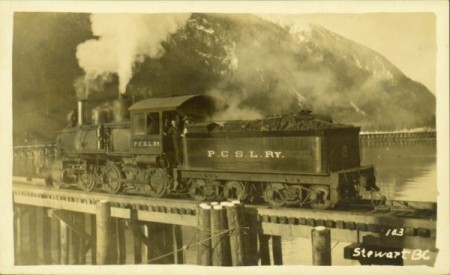
Courtesy of Northern BC Archives & Special Collections, Parker Photograph Collection, used as Academic Fair Use under University of Northern British Columbia policy.
This one is cheating a bit, since it’s technically in Canada and I’ve ignored the usual BC and Yukon railroads that everyone else shoehorns into Alaska Railroad histories. I figured I’d mention it since those other histories usually forget about it, and it came to within 1/2 mile of the border. (There were/are other railroads very close to Alaska on the BC side, such as at Anyox and Alice Arm).
The Portland Canal Short Line Railway was begun around 1910, and reached about 14 miles up the Bear River outside Stewart, BC. Owner Sir Donald Mann formed the Canadian Northeastern Railway Co to construct the line. The line was known interchangeably by both names (another version of the photo above has the tender labeled C.N.E. Ry). It served numerous rich mines in the area, including the Red Cliff mine. Mann’s eventual plan was to have a transcontinental rail terminus and port at the town (Instead, Prince Rupert became the modern rail terminus). This newsletter has a great description and history of the line.
The railroad had two 2-6-0 Pittsburgh steam locomotives, the #2 seen above, and #1 seen here from the rear (with another locomotive in the distance).
The Stewart mines slowly petered out, and in 1915 the steam locomotives and most of the cars were sold to the Canadian Northern and shipped South. The line was still used intermittently with small gas locomotives and ore cars. Floods in 1920 washed out many of the bridges, halting traffic on the line. Some work was done to repair bridges and track in 1928, but the railroad was again reportedly in disrepair in 1929. An extension to Fort Graham was proposed in 1934 but fell through.The tracks were scrapped during WWII.
Some historic photos of railroad operations around Stewart are located here.
The Alaskan town of Hyder (Known as “Portland” at the time, and located just over the border from Stewart) also had a number of mines up the Salmon River, but these were served by a system of aerial cable trams. The railroad apparently planned a cross-border extension at some point, as an application for right-of-way in Hyder was filed in 1920, approved by the US land office in 1922, but then cancelled in 1927.

________________________________________________________
Oliver Inlet Portage Tram
You can portage your kayak or canoe across Admiralty Island on a small tram, from Oliver Inlet to Seymor Canal. This was built in the 1950s by a local sportsman’s club, using surplus rails from Juneau mines. It was constructed in much the same way as other Southeast Alaska tramways, largely on wooden trestles instead of a gravel grade. It seems to even have at least one switch and siding. Users push the cars across the route by hand (or ride on downhills). A rusty cable winch, possibly no longer serviceable, can be seen in the background of this photo. The portage tram is still maintained as a state trail. Funding was requested in 2012 for upgrades, including a new aluminum-body rail car. A video showing most of the tram’s route can be seen here.

Photo from AK DNR, used as Public Domain.
______________________________________________________
Teller Tramway

Courtesy of the Alaska State Library, Henry N. Michael Photograph Collection, P92-13.
A small railroad or tramway is shown in this 1930s-era photo, labeled as Teller, AK. The line seems to lead to a dock or ramp and has several switches and branches leading away. I am not sure how far the track ran, it was likely used to move freight from the dock to warehouses or other buildings. I have yet to find any other information, and can’t confirm if this is in fact Teller, or some other location.
It is possible this was at the “Trade and Manufacturing Site” of Thomas A Petersen, surveyed in 1930. The survey does not show any tracks, but mentions a small wharf “in connection with” a warehouse set farther back from the shore.
The Yukon River and Bering Strait Railroad Company filed a preliminary map in 1901 to build a line from Teller to Council City, but apparently never did any serious work on the project.
______________________________________________________
Alaska Pulp and Paper Co Tramway
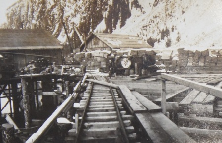
Courtesy of Alaska State Archives, Eugene Patrick Kennedy Collection, PCA 444
The Alaska Pulp and Paper Mill was located at Speel River in Port Snettisham in the 1920s. This company had a tramway around their plant, probably to move supplies and product between buildings. An incline may have also run up the company’s pipeline to a small dam at Tease Lake.
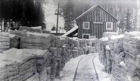
Courtesy of Alaska State Library, Eugene Patrick Kennedy Photograph Collection, P444-063.
Pulp mill history part 1 and part 2.
Photo of the log piles with tracks visible.
Rails to power house (what looks like incline track in the background are water pipes).
Manager of the company was W.P. Lass, Secretary was C.J. Keenan, and Engineer was G.H. Kirsch. Eugene Patrick Kennedy was involved with this project as well as the Speel River Project, his wife was Teresa Keenan.
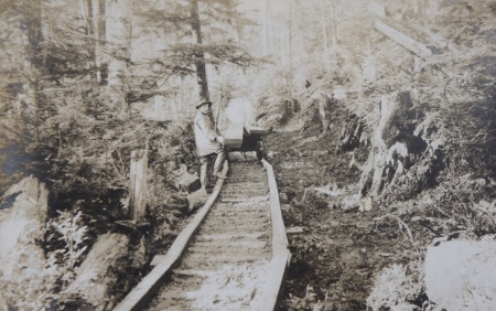
Tramway in woods at or near pulp mill, Courtesy of Alaska State Library, Eugene Patrick Kennedy Photograph Collection, P444-063.
The plant operated from about 1920 to 1924, promoters hoped to expand but found shipping costs prohibitive. A related plan to being electrochemical industry to the area, known as the “Speel River Project“, also included a short tramway nearby. Some of the equipment may have been used at both locations. The pulp company attempted several comebacks but finally liquidated around 1950.
______________________________________________________
Carlson Creek Tram
Related to the construction railway at Annex Creek, a freight tramway led up nearby Carlson Creek along the route of the power line from Annex to Juneau. It ran approximately 5 miles from Sunny Cove to Camp 4 on the powerline project.
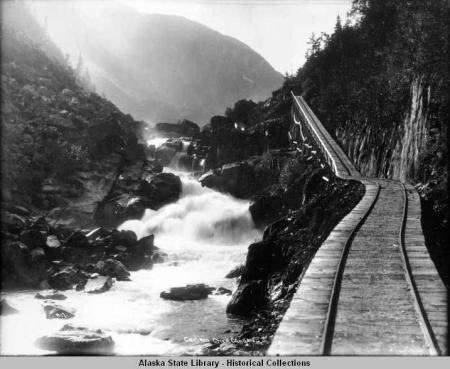
Courtesy of Alaska State Library, Alaska Electric Power Company Photograph Collection, P140-038.
Both the power transmission line and tramway were built by the Alaska Gastineau Mining Co. The tracks are marked on one of their maps as a “Railroad”, but are labeled as a tram in most photos. The company planned to eventually build a dam on Carlson Creek, in which case the tram would likely have been upgraded to a narrow-gauge railroad and equipped with the steam locomotive from Annex Creek for cement hauling. This plan never materialized, and the locomotive remained at Annex Creek until the 1970s.
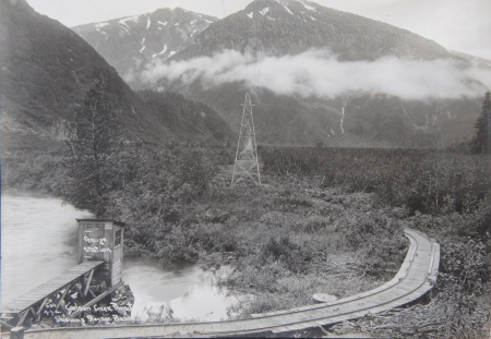
Courtesy of Alaska State Archives, Alaska Electric Light & Power Company Photograph Collection, ASL-PCA-140
Several photos from around 1912 (below) show sections of wood-railed and steel-railed track leading up Carlson Creek. The steel probably ran as far as the planned dam site. Track beyond that point would be underwater if the dam were built, so was laid with cheaper wooden rails. Although nearby and likely the same gauge, the track apparently did not connect directly to the tracks at Annex Creek. It likely terminated at the former Sunny Cove cannery. The steel rails used for part of the tram were apparently salvaged in the 1930s for use in nearby mines.
Wood tracks at Carlson Creek.
Tracks at Carlson and planned dam location.
Tracks leading to the beach.
Tracks in the canyon.
Approximate map of the tramway route:
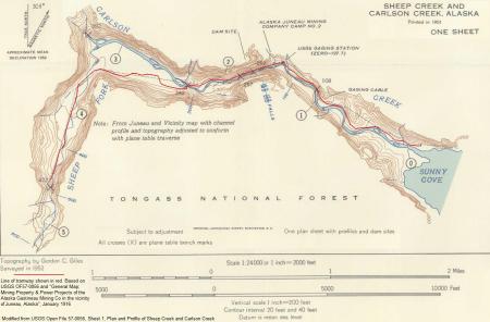
Detail of the planned Carlson Dam site showing the tramway:
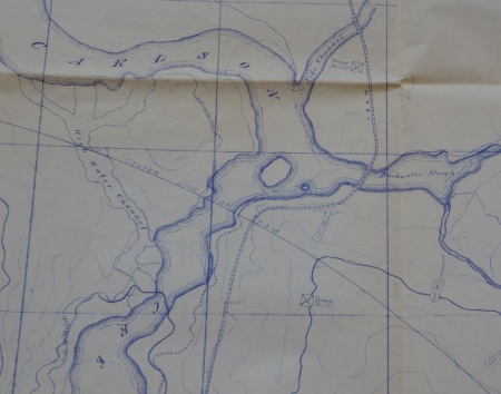
______________________________________________________
Sheep Creek Steam Railroad
Sheep Creek Basin is on the opposite side of Roberts Peak from Silverbow Basin. Several large mines operated in the Silverbow area, but some lesser known mines were also operating on the Sheep Creek side, including the Glacier and Silver Queen. The first of two railroads running up this valley was operated with steam locomotives between 1895 and 1912.

Sheep Creek railroad, 1912. Photo from Bob DeArmond collection, courtesy of Pat Roppel.
Prior to 1902 there was a small railroad to the Silver Queen Mine at Sheep Creek (although it likely served other properties nearby including the Glacier Mine). The Silver Queen operated from 1887 to 1911. The Nowell family became involved after 1895, and began building a railroad the mine (some sources describe an earlier two-mile surface tramway built in 1891, possibly a horse tram).

The railroad used several small steam locomotives. The first was a 22″ gauge, 3-ton geared 0-4-0 unit with 5×6 cylinders, built by the Risdon Iron Works. The locomotive was moved over from Nowell’s Silverbow Basin mine.

Modified from Risdon Iron Works Drawing 9281 (original image did not show enclosed cab). Courtesy of the California State Railroad Museum.
A photo shows the Risdon locomotive parked on the trestle above the Sheep Creek mill. This is undated, but likely prior to 1901 when a similar photo shows the mill slightly larger with a different locomotive on the track.

Courtesy of the Juneau-Douglas City Museum, JDCM2005_01_023B.
A close-up of the Risdon locomotive is below. The engine is identifiable by the long wheelbase and low height compared to the person in front of it.

Courtesy of the Juneau-Douglas City Museum, JDCM2005_01_023B.
The Risdon seems to have been underpowered for its intended use, so the company purchased an H.K. Porter locomotive in December of 1896. Porter records describe this as a 30″ gauge 0-4-0T with 5×10 cylinders, number 1718, delivered to the Nowell Gold Mining Co at Sheep Creek in July of 1897. Patricia Roppel’s Fortunes from the Earth reports that “A new locomotive” named the “William McKinley” was brought to Sheep Creek in 1897 (probably the Porter). Photos of this locomotive can be seen on pgs 92 and 93.
The track was probably widened to the new gauge, although most documents continue to be referred to it as 24″ gauge. A court document reports that ore was hauled with “steam locomotives of 5 to 10 horse-power over a narrow gauge railroad track”, hinting that both locomotives could have been used together. The Risdon remained 22″ gauge and was not widened, so if both were used it would have required dual gauge track. A report from 1897 mentioned that the line had 1.25 miles of tramway and three cars.

Porter Locomotive for Nowell Mining Co, Modified from Elevation Card 8038. H.K. Porter Co, ca 1897. Courtesy of Canada Science and Technology Museum.
A note in David Stone’s manuscript on the Sheep Creek mines mentions a railroad accident on March 5th of 1897. A new employee failed to apply the brakes in time, sending a loaded 5-car train crashing through the mill and into the creek 50ft below. The driver jumped clear and was uninjured. The report does not say if this involved one of the locomotives, but could have been one reason for retiring the Risdon.
The following photos show this steam railroad line (there is no overhead power wire, so the rails are not from the later electric line):

Courtesy of Alaska State Library, Alaska Electric Power Company Photograph Collection, P140-192.
Sheep Creek railroad 1
Sheep Creek railroad 2
Sheep Creek “Portal Camp” and railroad
Survey of the Silver Queen mill area showing railroad tracks:

Several photos show the H.K. Porter locomotive in 1912, as it was refurbishing the line and assisting in construction of the replacement electric railroad.

Courtesy of Alaska State Archives, A.K. McDaniel Photograph Collection, PCA 120.

Courtesy of Alaska State Archives, A.K. McDaniel Photograph Collection, PCA 120.
For over a century, the remains of the Risdon 0-4-0 steam locomotive could be found upside down in a ditch alongside the Sheep Creek trail. This was the former mill site and engine house, it is not clear if the locomotive was dumped here after becoming obsolete, was stored here until the building and tram trestle rotted away, or perhaps was involved in the 1897 crash.

In 2016 the Risdon was hauled out and moved to the nearby AJ Mine Gastineau Mill Tour, where it is on display as part of the tour’s collection of mine artifacts. The tour also has a cosmetically restored Porter 0-4-0 locomotive, originally from the Kensington Mine (it used to be on display in downtown Juneau).

The fate of the 1897 “William McKinley” Porter locomotive is unknown, it may have been sold or scrapped. A 1917 magazine mentions old milling equipment in Sheep Creek and other areas being sold for scrap. A 1912 photo (below) appears to show the saddle tank of a Porter-type locomotive on the Alaska Gastineau wharf. This suggests it could have been disassembled and shipped somewhere. However, a 1920 photo appears to show a small steam locomotive in an engine shed at the base of the incline. This could have been the 1897 Porter being re-used as a switcher on the wharf.

Image courtesy of the Juneau-Douglas City Museum, 2005.38.062.
______________________________________________________
Sheep Creek Electric Railroad

Photo courtesy of Alaska State Archives, Alaska Juneau Gold Mining Company Records, MS 999.
The second railroad up Sheep Creek connected the Perseverance Mine in Silverbow Basin with The Alaska Gastineau Mill at Thane. Around 1912, excavation began on the Sheep Creek Tunnel, a shortcut through the mountain for hauling ore to tidewater. The tunnel was begun by widening and then extending an existing tunnel, probably part of the Silver Queen mine. The “Old narrow gauge railroad or tramway” was repaired and used to haul supplies. A new electric railroad of 36″ gauge was built through the Sheep Creek tunnel into the mine, and on the surface from the tunnel to the Gastineau mill.

Alaska Gastineau electric railroad during construction (overhead power wires have not yet been attached to the wooden frames). Photo courtesy of Bill Binns, used with permission.
The photo below shows both railways at the Sheep Creek portal camp. The steam railroad’s grade is at left, the new electric railroad’s grade to the right:

Courtesy of Alaska State Archives, A.K. McDaniel Photograph Collection, PCA 120.
The new electric line did not follow the route of the steam railroad, instead hugging the opposite hillside on the Northwest bank of Sheep Creek. The new track was dual-gauge 24″ and 36″, with an “extra” inner rail allowing mine-gauge rolling stock to use the same track as the wider haul trains. Today, the Sheep Creek road follows the newer railroad grade and the public hiking trail follows the approximate route of the older railroad.
The following photo shows both railroads near the former Silver Queen mill. An electric haul train is on the new railroad (upper) and the old steam railroad (lower) has begun falling into disrepair:

Courtesy of Alaska State Archives, Winter and Pond Collection, PCA 087. Part of Panorama 1-43.
The next photo shows the electric railroad with dual-gauge on the mainline and single gauge on the siding. An incline descends towards the Silver Queen mill to the right, connecting the old and new railroads. The structure on the far side of the valley is a water flume.

Courtesy of Alaska State Archives, A.K. McDaniel Photograph Collection, PCA 120.
This photo shows another view down the incline to the old railroad. The Silver Queen Mill was taken over by the Alaska Gastineau and used as an experimental mill to test different processing methods. Another incline to the beach seems to have originally lined up with the old steam railroad, then been re-used for the newer electric railroad.

Courtesy of Alaska State Library, Alaska Electric Power Company Photograph Collection, P140-152.
Locomotive diagram from Sheep Creek electric railroad:

Courtesy of Alaska State Archives, Alaska Juneau Mining Company Records, MS 999
Passenger car diagram:

Courtesy of Alaska State Archives, Alaska Juneau Mining Company Records, MS 999
Ore car diagram:

Courtesy of Alaska State Archives, Alaska Juneau Mining Company Records, MS 999
Additional electric railroad photos:
Sheep Creek railroad near tunnel portal. Note a mine locomotive using the smaller set of dual-gauge rails.
Electric Railroad line in Sheep Creek, again note the dual gauge. The smaller trestle visible at right in this photo is probably the older steam railway.
Sheep Creek yard near the Gastineau Mill.
Locomotive and long string of ore cars in Sheep Creek valley.
Mine train at ore loading chutes underground.
Cars being pushed into unloading tipple.
Tipple spinning to dump ore cars.
Train of empty cars leaving tipple.
Aftermath of an explosion on the line.
Ore cars on the track.
Side view of train and Gastineau Channel below.
Incline tram from railroad down to beach level.
Map showing the Electric Railway (“Relocation” and the existing steam railway in 1913:

Courtesy of Alaska State Archives, Alaska Juneau Mining Company Records, MS 999
The Gastineau Mine began enclosing their new track in snow sheds soon after the above photos were taken. An avalanche in 1917 was reported to have destroyed 3,000ft of snowshed. By 1929 nearly the entire rail line was enclosed.

Snowsheds in 1920. Courtesy of Alaska State Archives, A.K. McDaniel Photograph Collection, PCA 120.
At the Gastineau Mill, a steep cable incline led down to the wharf, where tracks branched out to various warehouses and loading areas.

Courtesy of Alaska State Archives, A.K. McDaniel Photograph Collection, PCA 120.
There were many mergers between Juneau mining companies, eventually the Alaska Juneau, Perseverance, Ebner, and Alaska Gastineau were all consolidated, with most of the tunnels connected to form one system (there are over 120 miles of interconnected tunnel on at least 23 different levels). Multiple mills existed at several points along the hillside. By the 1920s, a railroad from one end of the mine ran through Sheep Creek and out to the Gastineau mill, and another line through Last Chance Basin to the AJ mill. Both railroads served the same tunnel network, but entered on different levels and had different track gauges. There was no direct connection between lines inside the mine. Until the 1960s you could ride some of these trains on a tour through the mines. Interestingly, another small section of rail with several branches is shown around Quartz Gulch in Silverbow basin, that area is now a large collapse pit known as the AJ Glory Hole.

Track and electrical diagram of Sheep Creek railroad. Courtesy of Alaska State Library, Alaska Juneau Mining Company Records, MS 999.
After the mines closed, most of the track, electric locomotives, and rolling stock from the Sheep Creek line were sold to the Portland Cement company, which used them at a limestone mine at Davenport, CA. This plant recently closed, and the company returned one of the historic electric locomotives to Juneau where it is on display in the State Museum.

______________________________________________________
Katalla/Controller Bay Railroads
The coal and oil fields north of Controller Bay are a complex and confusing area for railroad history. A massive rush towards development followed by an almost equally fast collapse left many unfinished railroads with relatively little documentation. The Katalla Project is a good source for this area and discusses much of the local history. The Copper Spike also details the history of railroad development here.
The area contained several boom towns which are now ghost towns, and there were many schemes to bring together the mineral resources of the area. It was felt that McCarthy copper smelted by Bering River coal could create an efficient local industry if brought together. Oil and timber were also promising development opportunities. The lack of a good deepwater port combined with uncertain mineral laws made these industries and railroads economically challenging.

Aside from the many planned-but-never-begun routes, approximately seven railways or tramways actually laid track in the Katalla area, including:
The Copper River & Northwestern Railway: After giving up on Valdez as a port for their railroad, the Guggenheim family tried Katalla in 1907. The “Catalla Company” (various spellings) acted as contractor, bringing in about seven 0-4-0 Alco locomotives. Some photos seem to show at least one larger locomotive and parts of larger engines at Katalla, and another photo shows a variety of locomotives at Katalla, although these could actually be from Cordova. The 0-4-0 engines seem to have been purchased from the American Locomotive Co’s stock on hand, but the “Katella Co” also purchased several 2-8-0 Alco (Rhode Island) 80-ton locomotives. Portable mine-gauge track and small hand cars were also used for initial grading, similar to the Alaska Railroad.

Guggenheim railroad work near Katalla in 1907. Mine-gauge track and cars on the right for moving excavated dirt, standard-gauge train on left carrying ties. Photo from S.P. Rodgers collection, Courtesy of Robert Phillips.
After repeated storm damage to the harbor facilities at Katalla, the port project was abandoned in favor of Cordova. The company intended to finish the branch from Katalla to the Bering River and join it to the main line near Miles Glacier, but legal issues with coal claims scuttled this development. When construction ended at Katalla there were 10 miles of grade and 8 miles of track laid. Some work seems to have been started from both ends, with track laid from the coal mines and from Katalla, aiming to meet near Bering Lake.
The Alaska Pacific Railway & Terminal Co, or Brunner Line: A direct competitor of the CR&NWRR, begun in 1907. This seems to have been a “nuisance railroad” designed to get in the way of the CR&NWRR and force them to buy out the company. The Alaska Pacific apparently never owned any locomotives or cars, but persisted in laying track as close as possible or even across the Copper River’s right of way. Several battles between rival work crews erupted, with sabotage and vandalism on both sides. Similar tactics had occurred at Valdez. The Alaska Pacific was abandoned after the CR&NWRR pulled out and the Katalla piers were destroyed by storms. The line reportedly never reached very far, although some later work was done along nearly the same grade by another company.

The Alaska Anthracite Railroad: This line ran up the East side of the Bering River from Goose City, with a possible branch up Stillwater Creek. Backed by Clark Davis of Seattle, the line’s official name was the Alaska Anthracite Railroad. It was also called by a variety of names including the Clark Davis Road, the Catalla and Carbon Mountain Railroad, the Controller Bay and Bering Coal Railway, the Katalla Coal Co RR, the Goose City RR, and the Katalla Anthracite Coal Field Railroad Company. Surveys for parts of this line under various names appeared as early as 1903. In 1905 “several railroads” were reported at Goose City, but actual track laying likely did not start for another decade

Copper River Northwestern Locomotive #3, later transferred to the Alaska Anthracite Railroad. Eric A. Hegg photograph, public domain from Wikimedia Commons.
Robert Phillips has provided some additional details on this line, courtesy of his grandfather Wesley Rodgers who worked for Mr. Davis. Rodgers performed initial surveys for the coal fields around 1907, as well as surveys for the nearby Guggenheim railroad on the West side of the Bering River. After the Guggenheim and Brunner companies lost interest in the area, railroad and coal rights were acquired by a group that included Clark Davis. Wesley Rodgers returned to the Katalla area to perform new surveys for the group, and later to build track, docks, and other facilities for the Davis railroad.
Clark Davis was later joined by John Rosene of the Northwestern Steamship Co (Rosene also financed other railroad projects around the state, including a proposed monorail from Haines to Fairbanks). Also involved in 1916 were John and James A Campbell (Logging company men from Seattle), and Charles Kinnear. Charles D. Davis (son of Clark Davis) was listed as secretary of the company at that time, Chief Engineer was Manche O. Bennett (later of the Oregon Highway Commission), and construction contractor was George Nelson.
By some accounts, construction actually began around 1909 using leftover equipment from the “Katalla Company“, which had been contracted to construct the Copper River and Northwestern. Other sources state that construction did not begin until 1916 and reached the Alaska Petroleum & Coal Co mine on Canyon Creek in 1918 (Clark Davis was also manager of this company). The construction initially involved track laid on cottonwood ties directly on the ground, with little or no built-up grade. Ties were cut at a sawmill about 1 mile East of Goose City. There were plans to extend the line South to the mouth of the Bering River, but swampy ground and constant flooding made this difficult.
A letter written by Wesley Rodgers in July of 1917 details some of the work needed to cross these “dismal swamps”. He reported that pile drivers and graders were then at work, and a locomotive had recently arrived and would soon be in use. Rodgers planned to build and equip an ocean dock, terminals, power house, machine shop, blacksmith shop, tramways, and a camp for the workers. He described the company’s existence as precarious, surviving only by the determination of Mr. Clark Davis.

The line had at least one 0-4-0 saddle tank locomotive named “Ole”, previously used at Katalla and possibly Cordova, as well as some flat cars. In The Copper Spike, Lone E Janson notes that two locomotives and 16 cars were purchased by the company. An article from 1916 mentions two flat cars equipped with gasoline engines, as well as two “donkey engines” in addition to a steam locomotive (in this context, a donkey engine is probably a small portable engine for pile drivers or sawmills). John Taubeneck reports a gas speeder acquired in 1923, a Skagit Iron Works (Motor Appliance Co) model 4-40, Construction Number 112. Some of these resembled powered flat cars, as seen here, here, and here. The speeder is reportedly still parked near the steam locomotive.
A court case filed in 1919 mentions a home-made flat car used to transport workers between construction camps until it was wrecked and abandoned. Testimony in the case also refers to the construction locomotive as a twenty-ton “Donkey engine” (in this context, a small locomotive).
A 1922 report also mentions multiple locomotives:

A photograph in Alaska Geographic’s “The Copper Trail” shows a small 0-4-2 wood-burning locomotive (without saddle tank), attributed to the Alaska Anthracite in 1919. This is a different design than the known 0-4-0 saddle tank engine left at Goose City, and does not exactly match any other locomotive I have been able to identify in Alaska. Its present whereabouts are unknown.
In November of 1918, the El Paso Herald reported that the first trainload of coal had reached tidewater from Carbon Mountain, and 300 tons per day were being shipped. The line was apparently idled during WWI due to labor shortages, with 22 miles of track laid. A fire in 1919 destroyed much of the mining camp, further hampering development.
About 1,200 workers were reportedly hired to finish the line in 1921, although other sources mention that it was never more than 80% “finished”. The railroad floated several bonds in 1921 to expand the route (also hinting at multiple locomotives). New management included V.G. Garvey, H.C. Blunk, and W. N Nelson, who landed 86 tons of materials in 1923 and claimed the railroad would be completed that year.
Despite these ongoing claims of near-success, the company defaulted on its bonds in 1924 and went into bankruptcy. A 1925 article reported the arrest of Charles Davis for the alleged unlawful sale of railroad bonds. A 1926 article mentioned a foreclosure sale and claimed the new owner would continue and expand the line. A USGS bulletin from that year stated that the line was in good condition aside from some damaged bridges. It was estimated to cost $1 Million to rehab the line, but an Interstate Commerce Commission investigation revealed that “rolling stock was negligible and in great disrepair”. The investors sued the former directors, no buyers could be found for the company assets, and the investor’s spokesperson called the line “the proverbial White Elephant”.

Aerial photos show overgrown grade reaching from the flats near Controller Bay, and up the Bering River to about Stillwater Creek. Another grade is visible leading up Stillwater Creek from its junction with the Bering River, ending near Trout Creek . This would have likely served the Monument Mine on the Cunningham group of claims. It was mentioned in 1916 that a line following this route could be extended all the way to Shepherd Creek and perhaps further.
I am not certain if a trestle across the Bering River (approved in 1911) was ever built, but it appears that track was laid on the Stillwater Creek grade. A town named “Stillwater” sprang up at the junction of the Bering River and Stillwater creek. This town could be reached by shallow draft vessels and barges. The docks are seen here, with a barge on the left apparently carrying two Katalla Company dump cars. Another photo that appears to show Stillwater is here, with similar cars on the dock. The date and text suggests that this was originally part of the Copper River & Northwestern’s project to connect Katalla with Carbon Mountain. A forest service report mentions a culvert and railroad trestle with rails remaining at Clear Creek, a tributary of Stillwater Creek. It is possible that the Alaska Anthracite purchased or took over the track up Stillwater Creek after the CR&NWRR pulled out. The unidentified 0-4-2 locomotive could have operated on the Stillwater branch with a ferry across the Bering River to the main line. On the 1921 map of the railroad, Stillwater is referred to as “Upper Junction”, and the track from there to the coal field is labeled under construction. A survey (USS 190) from 1907 also shows track on the South side of Stillwater Creek (West side of the Bering River).
The Alaska Anthracite’s first port was on the Bering River at a place called “Goose City”, which became the headquarters of the line. The company planned a deepwater port, which some contemporaries suggested was an investment scam, but there are indications that a dock was at least started. A report in the Nenana Daily News from April 5 1918 states that contractor George Nelson had just completed a three-mile long wharf in Controller Bay for the Alaska Anthracite, and was constructing the approach to said wharf, when spring ice coming down the Bering River destroyed the pilings. A piece in the Alaska Railroad Record says much the same.
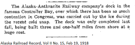
Both Goose City and Stillwater are now largely-forgotten ghost towns.
Kush-Ta-Ka Southern Railway: A railroad grade can be found leading from the head of navigation on Shepherd Creek, to the junction of Carbon Creek near the Alaska Development Co’s Carbon Camp. The locality is sometimes listed as “Carson Camp” on older maps. This grade is not directly connected to any of the other construction projects in the region, but may have been part of the Kush-Ta Ka Southern Railway. This company filed surveys in 1909 for a line running from the Bering River to Lake Kushtaka, with a branch to Lake Charlotte by way of Shepherd Creek and Carbon Creek. The president of the company, C. F. Munday, owned coal claims along Carbon Creek.

Courtesy of Alaska State Archives, George Danner Map Collection, MS 262
The existing grade visible on aerial photos does not quite match the survey, but part of it comes very close. The Shepard Creek branch may have been a temporary construction line for access. Many railways in this area seem to have used rivers and creeks as shortcuts to their lines, bringing in supplies and materials by sternwheelers and smaller vessels to avoid the expense of large bridges (A photo of such an operation is here). I am not sure what year construction began or if any locomotives were in use here.
The grade is mentioned briefly in 1905 and again in 1911. It may have been started by another company, as both the Alaska Pacific Railway & Terminal Co, the Katalla Co, and the Copper River Northwestern all had prospective routes along Shephard Creek. A 1907 document claims that the Alaska Railway and Terminal Co was constructing a 26-mile branch up Shepherd Creek towards Lake Charlotte, but their proposed route is on the other side of the creek.
An anecdote from The Copper Spike mentions the Alaska Anthracite Railroad’s locomotive “Ole” being run at Shepherd Creek.
Modern surveys label this as an old railroad grade:

Redwood Tram: A tramway running from the oil town of Redwood to the shore of Controller Bay. This was begun prior to 1903, and may have lasted until the 1930s. It allowed supplies to be hauled from barges at the shore to the oil camps across the swampy river delta. It was owned by the Alaska Development Company under R.C. Johnston of California. Trams in this area were referred to in a 1906 article as having steel rails. A 1911 article reported 2.25 miles of tramways in the area.
Katalla Slough Tram: A tramroad running from Katalla Slough to oil wells and the Chilkat Oil Co’s refinery, begun prior to 1903. This may have operated until the 1930s. It is visible on the right in this photo. Another photo shows the tram on a curving trestle near the oil refinery. It is listed as an “Old RR Grade” on the 1950 Cordova (A2) Topo map.

Courtesy of Alaska State Archives, Alaska Road Commission Photograph Collection, PCA 61.
1904 survey showing the Katalla Slough tramroad and Redwood tramroad:

Mirror Slough Tramroad: A 1906 mineral survey of the Alaska Coal-Oil Company shows a tram road running from Mirror Slough to several buildings and oil wells. The tramway’s wharf is adjacent to a bridge on the abandoned Copper River Northwestern RR’s Katalla spur. Modern aerial photos show the CR&NWRR grade intersecting the tram’s route at Mirror Slough.

Canoe Landing Tram: A short tramway which led from a mine at the base of Mount Hamilton, to “Canoe Landing” on Shepherd Creek. Likely hand pushed or animal-powered. The coal at this mine was reportedly low quality and the mine did not prosper.
McDonald Mine Tram: Another short incline ran from the McDonald mine to the shore of Bering Lake, below Hamilton Mountain.

Katalla Freight Tramway: A photo shows narrow gauge rails on a dock at “Catalla” with a small rail cart at the far end. This seems to have run from the end of the wharf to a warehouse or store. On a 1907 map this is listed as the Katalla Landing Pier. More views of these tracks are here and here, they appear to be wooden rails with strap iron tops.
Chilkat Cannery Tramway
A short tramway seems to have run out the wharf of the Hoonah Packing Co’s cannery at Chilkat, as seen on the right of this photo. There was also a cannery at a place named Chilkat near Haines, which leads to some difficulty in identifying photos of the operation.
Below is a general map of the region. As-built rail and tram alignments have been traced from what is visible on aerial photos and topo maps (parts may have been only grades or unfinished routes). I have not included planned routes here, only those with visible signs of construction.

The 1910 map below shows many of the railroads proposed (but not necessarily built) in this area:

Another map from 1916 showing some of the proposed railroads serving coal leases near the Bering River.

Yet another map of proposed railway routes in the area (from 1903) can be seen here.
A topographic / geologic map of the area showing coal formations is here.
Another 1916 map shows an alternate proposed route connecting the Copper River & Northwestern to the Alaska Anthracite via Shepherd Creek, bypassing Katalla completely.
Several news articles in 1920 claimed that Falcon Joslin of the Tanana Valley Railroad would be constructing a “motor truck road” from Trout Creek to Bering Lake. The line would consist of planks laid on ties, with trucks used as locomotives, and would eventually be replaced by a “regular railroad”. I have seen no evidence this was ever built, and the proposed route would not make practical sense.
Eventually, the lack of any reliable port facilities killed off most of the railroads in this area. Controller Bay is essentially one giant tidal estuary, with shifting mud and swampy shores creating a construction nightmare. On at least one occasion, the government built wing dams in the Bering River to improve the channel between Chilkat and Stillwater, but these would have needed constant maintenance. Katalla suffered repeated storms which flooded the town and washed out the tracks. Various schemes were devised to build long piers out to deep water, but the few piers and breakwaters begun at Katalla were washed out soon after being started. The larger railroads gave up on the area around 1907. The Forest Service reports that about 6 miles of standard gauge track still exist at Katalla, but in very poor condition.
An uncertain regulatory environment also hindered serious development in the area. The changing coal land laws of the time made companies unwilling to invest in railroads to claims which could be rescinded at any time.
The Alaska Anthracite RR operated until the early 1920s. The oil refinery near Redwood (and maybe the trams there) operated until the 1930s providing gasoline and kerosene to local canneries. After the refinery burned down in 1933, the wells were abandoned.
A locomotive of the Alaska Anthracite RR remains at Goose City, along with some other rolling stock. The Forest Service lists it as an Alco Dickson #41751, and other sources indicate it was number 3 on the CR&NWRR’s dinky roster. It is reportedly named “Ole”. There are some great recent pictures here. An aerial photo is here. Some historic photos can be seen here. There is occasional talk of moving the locomotive to Cordova for restoration and display. An abandoned caboose is also reported in the area.

In the 1950s one of the proposed sites for Project Plowshare testing was the townsite of Katalla, with early studies done to determine if the region’s ongoing harbor problems could be solved with nuclear bombs.
Additonal sources are below. I may get around to making an actual bibliography some day.
USGS Bulletin from 1903-1904 mentioning various tramways.
Katalla and Controller Bay project.
Mining American, Vol 49, 1904.
______________________________________________________
Dolomi Rail Lines

The town of Dolomi and surrounding area had a number of mining operations with various tramways or railroads. Maps of the region show a tangle of overlapping mining and homestead claims, some of which conflicted with eachother.

A survey from 1908 shows three tramways originating at Dolomi, one running up Beauty Creek towards James Lake, and two running up Paul Creek to Paul Lake. A 1909 survey shows tracks leading down both sides of Paul Creek where it reaches Dolomi Harbor (also known as Johnson’s Inlet or Johnson’s Chuck, after a local Native named Peter Johnson who had a home there in 1902 and discovered some of the gold).

The James Lake tram (sometimes called a railroad) ran to the Golden Fleece Mine, which operated from about 1901-1905 and again in the 1930s. It was described as a 2ft tram in survey notes, likely referring to the track gauge. This tram is sometimes reported as reaching the “lower end” of James Lake, with ore hauled across the lake on boats. It it shown thus in the following 1908 map (but is misattributed as the Valparaiso tramway):
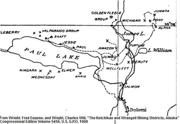
The map above does not match up with earlier surveys, which show the “Golden Fleece Tramway” running mostly on the East side of the creek, and wrapping around the East side of James Lake to end at the Golden Fleece mine. It is labeled “Wooden Surface Tramway” on a 1916 survey.
A possible explanation for the discrepancy in James Lake tram routes can be found in a 1900 fisheries bureau report. Fisheries Agent A. D. Harlan met with Mr. John Heerdt on Aug 28th of that year. Heerdt and his partners, I.B Capp, W. F. Shedd, B. A. Eardley, and Charles Guzman had built a dam on one of the small lakes at the head of “Peter Johnson’s Creek”. The dam let the miners raft ore across James Lake to the top of their tramway, rather than building the tram all the way around the lake. Harlan ordered the miners to demolish the dam and allow free passage to spawning salmon. He asked Peter Johnson to keep an eye on them to make sure they complied. Afterwards the miners would have been forced to extend their tram to the adit.
1901 survey showing tramway around James Lake:

Charles Guzman was also involved in a failed plan to build an electric railroad up the Salmon Creek valley from Hyder.
As an interesting side note, a report from 1904 notes “a peculiar and advantageous feature” of the Golden Fleece mine, namely “several natural limestone caverns which apparently follow the mineral deposits” and which had been incorporated into the mine workings. Some maps showing part of these caves connected to the mine can be found here and here.
Of the two trams from Dolomi to Paul Lake (on opposite sides of Paul Creek), at least one would have served the Valparaiso Mine on the North shore of the lake. Some publications refer to it as a narrow gauge railroad. This photo showing a horse-drawn cart is labeled “Tram at Valpariso” in Alaska, but is otherwise not identified. The Valparaiso tramway was reportedly completed in 1907. Survey notes indicate that the Valparaiso tram may have been the southernmost track along Paul Creek, and was 2ft gauge.
This mine was worked from around 1898-1920, prospected through the 1920s and 30s with another attempt to re-open in 1945, then abandoned. It was operated for some time by Charles Dunton, who also operated the Harris River mine near Hollis. From 1907 to 1916, the Princeton Mining and Milling Co owned much of the property in this area. One of the main developers was Bedson A. Eardley, who staked some of the claims around Dolomi personally, and was general manager of the Princeton Mining and Milling Co. He was also involved with the Golden Fleece Mine. His wife Janet took the photo shown at the top of this section, showing the “Mine Railroad at Dolomi“. More information on B.A. Eardley is here. More of Janet’s photos (including some taken around Dolomi) can be found here.
A 1967 Alaska DNR report mentions that the tram from Paul Lake to Dolomi (the Valpariso tramway) had steel rails. The “remnants of a small gasoline-powered railroad engine” were reported at the Dolomi town site in 1966, as well as “a good deal of equipment” at the Valpariso Mine. Another 1967 report states that the “narrow gauge railway from Dolomi Harbor to the south end of Paul Lake is carried entirely on trestlework”. Trestle-type railways were common in Southeast Alaska as they could bridge uneven terrain and allowed easy snow removal. They were cheaper to build with local lumber than a normal gravel grade would have been.
Firsthand reports indicate both a gasoline and an electric locomotive used here. Some photos of mine equipment near Dolomi (probably at the Valparaiso Mine on Paul Lake) are available here.
The second tramway from Dolomi to Paul Lake is a mystery. It could have been a replacement for the Valparaiso mine’s original route, or could have served one of several other mines on Paul Lake. Survey notes refer to it as a “5ft tram”. If the track gauge was 5′ (or even standard 4’8.5″) it would be rather large for a mine tramway. Smaller gauges were more common in Alaska due the narrower grades and tighter curves offered. Five feet could also refer to the total width of the trestle-top walkway, and not the track gauge.
Other tramway related items noted in the surveys include “An uncompleted surface tram 4 feet wide” and a “tramhouse 10 x 14 feet”, both near Paul Lake.
There were also marble quarries on each side of Dolomi Bay, although no tracks are shown on the surveys of these. Across the hill on Clarence Strait is a short tramway shown on a 1906 survey, leading to a quarry of the American Coral Marble Co.
Another short tram is mentioned as being associated with Si Goodro’s prospect 1 mile North of the Valparaiso mill, described as “about 1/4 mile of corduroy tram road”.
Dolomi area tramways:

______________________________________________________
Cymru Tramway
The Cymru mine included a tramway from Miller or Mineral Lake to Clarno Cove on Moira Sound (Prince of Wales Island). Similar to the Valparaiso Mine, ore was brought from the mine across Miller Lake by barge, then down the tram to the ocean dock. The line was built around 1906, was 36-inch gauge with 20lb steel rails, and operated one or more gasoline locomotives. The mine was damaged by fire in 1907 but reopened in 1908. By 1928 it was reported to be largely abandoned with the tram line overgrown. Various lengths for the track are given in different reports, from 4,200ft to “two miles”.
An adjacent industry was the American Coral Marble Co, also at Clarno Cove. This company built a wharf and staked a town named “Baldwin” before 1907, the quarry included a 5′ wide, cable-hoisted incline tram for moving marble blocks to the wharf. This tram was about 1000′ long and operated by a stationary 45hp engine. The marble operation was abandoned soon after opening.
The Engineering and Mining Journal from July 1906 mentions a “gasolene” locomotive being shipped from Ketchikan to Baldwin for use at the Cymru mine. A 1916 photo and description seem to indicate that a home-made gas locomotive was in use, and had replaced mules for hauling ore. Another 1916 article mentions multiple gas locomotives at Cymru.

______________________________________________________
Iditarod & Flat Tramroad

An 8-mile “tram road” between Iditarod and Flat was built around 1910, with cars pulled by mules. It hauled freight from the Iditarod river port to the Flat mining district, including several large gold dredges in disassembled form. It operated mainly in the summers and remained a transportation link between the two towns for a decade.

Some accounts say the line ran down Iditarod’s main street, while others say it ended at the general store just outside of town. There were plans to replace the tram with a narrow-gauge railway, but they do not seem to have fully materialized. The Mutchler (or Muchler) family is said to have begun the line, David Mutchler reportedly ran the tramway in various years, as did Jake Mutchler. George Mutchler and his wife had a hotel nearby, and the family also ran a blacksmith shop in the area. The Mutchler brothers also hauled freight with wagon teams, seen here.
Robbers held up the tram in the fall of 1911, stealing $35,000 in gold dust which was bound for the bank in Iditarod. Louis Gorman and August Bronson were later caught and found guilty. Supposedly part of the loot was buried near Cottonwood Creek and has yet to be found.

Various changes were proposed and experimented with on this tramway at different times. New mule-cars were shipped via the Yukon River in June 1911. An article from August of 1911 claimed the Mutchlers had sold the tram to the Iditarod Traction Company (managed by James E Wilson). The new owners planned to tear up and re-lay the rails along Otter Creek. The Otter Creek branch may have actually been an extension to the original track, perhaps as far as the town of Discovery. The State of Alaska lists an “Otter Creek Tramway – Moose Creek Trail“.
The Fairbanks Daily Times of Sept 21, 1911 printed the following schedule:
Iditarod Traction Company.
The following schedule of trains becomes effective at once:
Leave Iditarod 8 a. m. and 4 p. m.
Leave Flat 9 a. m. and 5 p. m.
1912 was a busy year for the new tramway operators. An article from March of that year stated that Wilson would be purchasing steel rails and gasoline motor cars to replace the wooden rails and mule power. An April article reported that the Iditarod Traction Company had ordered “new cars and motors” to haul two Guggenheim dredges formerly used in Dawson. It was said that the tram line would be rebuilt and extended, and that the rolling stock was at the foot of Lake Labarge awaiting shipment. Another article from June reports that the company was installing two 45-horsepower motors, which would supply power to the tramcars. Also in June it was reported that the line was extended several miles, strengthened, and had new rolling stock added (A number of 4-wheeled flatcars were purchased from the Seattle Car & Foundry Co around this time).
In July the traction motors were shipped from Dawson on the steamer Schwatka, along with several 8-ton freight cars. A Mr. Oscar Anderson was mentioned as conductor on the tramway. By August the newspapers stated that a 45-horsepower motor made the round trip from Iditarod to Flat with 6 tons of freight, a load that previously would have required 5 or 6 mules (in this context, a “motor” is a small locomotive or self-powered car such as this or this).
In January of 1913 the Times reported B. Cockrill as the new manager, Mr. Cockrill said that “more steel rails will be put down on the Iditarod-Flat City tramway during the coming year”.

Despite all the talk of upgrades, photos and USGS reports indicate the tram was back to using wooden rails and draft animals in 1914. It is not clear what became of the steel rails and gasoline motor cars. Dredging displaced most of the small-time miners, as it was more efficient and required fewer men to operate. The resulting decline in population may have caused the tramway to lose money, forcing the new equipment to be sold off. Dredging could also have destroyed the Otter Creek extension, if it was ever built.
In 1915 the USGS reported that a Ford Model T mounted on a rail truck had been added as the main motive power of the line (Model T engines were around 20hp, so the reported 45-horsepower motors must have been something else). Ownership seems to have reverted to the Mutchler family by 1917. A Popular Science piece from that year claimed horse-drawn cars were still in use, but re-used a 1914 photo.
A 1916 article in the Iditarod Pioneer described two additional tramway motor cars received by the Mutchler Bros. A heavy car for freight hauling was equipped with two motors totaling 44hp and was geared for 10-12mph. A lighter car was intended for faster passenger traffic.
A 1923 photo shows the town of Iditarod abandoned, with the remains of two slightly larger rail cars featuring dual-axle trucks.

Courtesy of Alaska State Archives, Alaska Road Commission Photograph Collection, PCA 61
The Alaska Resource Library has some archival information on this tram available here.
Some dredge history and photos can be found here.
Additional photos:
“East along Muchler’s Tram from near M & M Bank”
Another photo of the rails
Another photo of a horse-drawn tram car
End of track in Flat City with sacks of mail on flat cars
Interestingly, Iditarod was also home to a Phoenix steam log hauler. These machines were essentially steam locomotives with tractor treads and skis instead of wheels, and were designed to haul “trains” of wagons or sleds. Some photos of the abandoned engine can be found here.
Example steam log hauler (not the one from Iditarod):

Image courtesy of The National Archives.
The log hauler was not directly related to the tramway, although both served the dredges. The hauler was apparently used to bring firewood from the Iditarod River to the power plant in Flat over an ice road in the late 1910s. According to an interview with resident John Miscovich, it was owned by the Guggenheim dredging operation and was supposedly cobbled together by a group of steam engineers, rather than being a standard design. However, close-ups of the builder’s plate from a 1980s survey identify the unit as a Phoenix.

Phoenix Log Hauler in 1988. Photo from US BLM, used as public domain.
A 1988 report mentioned that the tramway’s Model T locomotive still existed, but had been moved across the river from Iditarod.

Iditarod Model T in 1988. Photo by US BLM, used as public domain.
The car in the above photo has rubber tires on the rear wheels. It could have been converted back to road use, or could have had rail flanges alongside the normal tires. Such arrangements were common on the Copper River Northwestern Railroad, as seen here and here.
Dredge operations ended around 1918. The Mutchlers reportedly closed the tramway in 1920, sold their house, and moved away from the area. Oral history interviews report that Peter Miscovich bought the tram and cars for $100 and broke it up for firewood. Today Iditarod and Flat are ghost towns, with some small placer mines still occasionally operating near Flat.
Possible engine roster for the Iditarod Tramroad:
-Two 45hp “Traction Motors” installed summer 1912.
-20hp Model T on flanged wheels, installed 1915. Remains on-site.
-44hp “two motor” car, geared for freight, installed Summer 1916.
-Light passenger car, installed Summer 1916
______________________________________________________
Sulzer Tram
A photo showing the “upper terminal” at the Sulzer or Jumbo mine is tagged under “mine railroads” in the Alaska digital archives. There seems to be a tramway with wooden rails built on a walkway for men and/or horses. This may simply be a short ore cart line that ran from the adit to the top of a cable tram, as other accounts describe an aerial cable tram from the mine to the mill rather than a surface track.
______________________________________________________
Hadley Tramways
The town of Hadley was home to a copper smelter serving local mines, including the Mamie and Stevenstown workings. Although large, this smelter apparently operated for only a few years due to unstable copper prices. Charts from 1906 show rail lines leading towards the mines and between the town and a nearby sawmill. A 1961 USGS document refers to this as a “small railroad”. The town had a large hotel and store as well as a saloon, and according to some accounts the company rented several cabins to “various and sundry women of ill repute”.
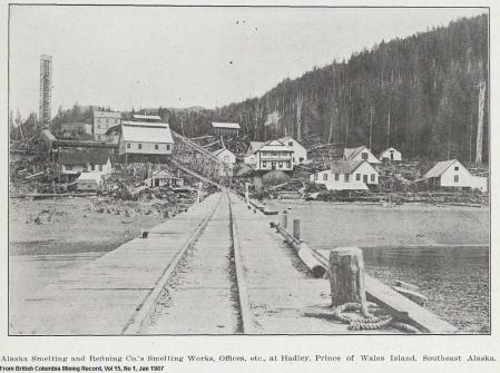
Some of the companies involved with this operation at various times included the Brown Alaska Mining Co, the Hadley Consolidated Copper Co, and the Alaska Smelting and Refining Co. In 1915 the property was operated by the Granby Consolidated Mining, Smelting, & Power Co of Canada, who also ran a large smelter and small steam railroad at Anyox near the southern border of Alaska.

A 1903 report in the British Columbia Mining Record indicated that slag would be handled by two locomotives at Hadley. An Engineering and Mining Journal article from the same year reported that two had been ordered, and both The Mines Register and The Copper Handbook of 1906 and 1907 reported locomotives in operation hauling 5-ton slag cars at Hadley. Later reports indicated a pipeline for handling granulated slag, so it is unclear what became of the locomotives. A 1915 report and map shows the route of the surface tramway to the mines, and mention that it was horse-drawn. The section from the Mamie Mine to the Stevenstown mine was a cable incline. The smelter also had an aerial tramway to haul ore.
Below is a tracing of the tramway route over a modern-day topo map:

The photo below shows several tracks leading up from the wharf towards the smelter and into the woods to the left, leading towards the Mamie Mine. A string of cars is on the wharf track, possibly the 5-ton slag cars.

This photo shows a similar view, with what could be a locomotive on the track (unfortunately the photo is damaged in that area). Tracks of several different gauges appear in this photo, the tramway curving up the hill to the mine seems to be wider gauge, with mine-gauge tracks for mine cars running parallel on the wharf.
A photo of the beach in this area shows a boiler which looks quite similar to a steam locomotive. This could have been a stationary-mounted boiler for a steam hoist, one document mentions a 90hp “locomotive-type” boiler used at one of these mines. This photo shows a decaying ore cart at the Mamie mine. Additional photos of the area are here, including another stationary steam boiler.
______________________________________________________
Kiam Tram
A two-mile long “ground tram” was built at Kiam, AK on Prince of Wales Island around 1901. A report describes “six-car ore trains with a total load of 15 tons”. The surface tram totalled 12,160ft in length, connecting to an aerial tram at the South end and ore bunkers at a wharf on the North end. The surface tramway is sometimes referred to as a “gravity tram”, which could indicate a cable car or funicular. The length and curves of the route would have complicated such a design, but a diagram of the tram terminal does show a winch aligned with the track.

Reports indicate that the mine was located in 1899 by George McKenzie, the transportation system was built between 1901 and 1905, then the mine closed for a year due to low copper prices before reopening in 1907 under the management of H. W. Turner (The Copper Handbook reports that “…management was overenthusiastic, and built a tramway and wharf before a mine was opened”.) The new owner was the Omar Mining Co, which purchased it from McKenzie, they seem to have only operated for a short time. The mine was still semi-active around 1916 when Fred Heckman of Ketchikan re-staked the claims, but production seems to have petered out at some point in the first decade.
The Hart Crowser environmental company has a photo that appears to show a medium size rail car (or perhaps several small ones) at the Khayyam mine.
More information on the mine is here.


A 1946 USGS report noted that the dock was not usable at that time, and described how supplies for the Bureau of Mines survey were simply “packed carefully” and dropped out of planes over the temporary camp (parachutes were not available). Five barrels of oil and 20% of canned goods were lost in this way. The report recommended using cargo parachutes for dynamite deliveries.
As with many historic sites on Prince of Wales Island, the Kiam tramway route has been obscured by logging clearcuts.
______________________________________________________
View Cove Tram
A limestone quarry operated at View Cove on Dall Island from about 1928 to 1942. Limestone was moved from the quarry pit to a crusher by small Plymouth switcher engines built by the Chrysler Corporation. At least one is reportedly still on-site. The quarry also had a cable-pulled incline tram.


John Taubeneck provided the following stats on the locomotives. Both were 8-ton standard gauge 0-4-0 unites, Construction Numbers 2973 and 2974, built in July of 1928. They were owned by the Pacific Coast Cement Co of Seattle and then leased to the Superior Portland Cement Co in 1930 until the quarry closed around 1942.
Manley Kjonaas has a web page with photos of locomotives in operation and as seen today. He has more information on the ghost town of View Cove here.
______________________________________________________
Tokeen Quarry Tramway
Located on Marble Island near Prince of Wales Island, the Tokeen Quarry was operated by the Vermont Marble Company. It opened around 1909 and had various tracks for transporting marble blocks to the wharf and for positioning cutting machinery. The tramway from the quarry to wharf appears to have been broader than standard-gauge, allowing very large pieces of marble to be transported. This photo shows some kind of tractor-type machine on rails. Stone from this quarry was used in buildings around the US, including in Seattle and in Juneau.

______________________________________________________
Shakan Tramways
The town of Shakan, just a few miles South of Calder, had a mine tramway built around 1916. This is sometimes confused with the Calder marble operation, but the mine here was for Molybdenum or “Molybdenite”. Shakan also had a sawmill and cannery, and was the site of a Tlingit native village. The cannery apparently featured some tramway rails on their dock and possibly on a pipeline trestle.
In 1916 it was reported that the Treadwell company was developing the Molybdenite discovery near Shakan, and had installed a tramway from the wharf to the mine about 3/5 of a mile inland. After Treadwell’s workings under Gastineau Channel collapsed, this became an attempt to keep the Treadwell mills and smelters working. Ore would have been shipped to Douglas from Shakan for processing.
A telegram in 1918 describes continuing work on the tramway, but by some accounts the project was put on hold that year when the end of WWI lowered metal prices. Another article from 1920 mentioned that Treadwell had installed a 4000′ tramway at Shakan and had installed an electric furnace at Douglas for handling the Molybdenum.
The mine tram is shown on surveys from 1921 as a “Trestle Tram” serving the Alaska Chief series of claims. The 1921 survey shows a wye and switchback to an incline for cars to come down to the wharf. The survey notes describe track running Northwest from the mine to the wharf, constructed on a trestle of heavy timbers with cross ties carrying 30lb rails, and costing $9,927.50.

The Molybdenum project apparently did not pan out, as there was never much production and Treadwell’s mills at Douglas burned down in 1926. In 1927 the neighboring cannery appropriated 6 tons of rail left on the Shakan dock, settling up later for market prices. It is unclear what the cannery did with these rails. A 1917 nautical chart shows two tracks leading back from the cannery towards the steeper terrain (one on a trestle, possibly for constructing a water pipeline. The chart also shows a third track from the water to a building, which was likely a marine railway. The cannery’s trestle is visible in this photo and this photo, and a likely water pipe or flume can be seen in this photo.

I could not find a description of any motive power used here. Treadwell would have had a variety of surplus equipment idled from the Douglas operation, including steam, electric, and gasoline locomotives. They could also have used draft animals to operate the tramway.
______________________________________________________
Calder Funicular
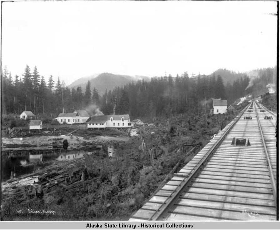
Courtesy of the Alaska State Library, Winter & Pond Photograph Collection, P87-0429.
This was another marble quarry, just North of Shakan. It had a 3,200ft standard-gauge inclined tram, powered by a cable and winch.
Looking down the incline towards the wharf:

Courtesy of Alaska State Archives, Winter & Pond Collection, PCA 087-430
Top of the incline, showing diverging funicular tracks and winch house:

The tramway, seen above and also here, appears to be a three-rail funicular. A diagram illustrating how this design works is available here, courtesy of Wikipedia. A modern funicular using this track arrangement is in operation in Dubuque, IA.
The quarry later reopened as a crushed marble/limestone producer. The tram has been replaced by trucks.
______________________________________________________
Ketchikan Funicular
Not strictly a railroad, but now that I’ve described the Calder funicular, I should mention that Ketchikan also has one. The Cape Fox Hill Funicular is a single-car counterweighted system with one track going up a hill above Creek Street. Some photos and video are linked below:
Photo of Ketchikan funicular.
Another photo.
View looking down the track.Video of the funicular in action.
______________________________________________________
Poor Man Mine Tram
The Poor Man Mine at Kasaan Bay operated from around 1900-1918. The mine tram, based on this photo, appears to be a very narrow wooden-tracked affair. (I believe the label of Karta Bay is incorrect, unless this is a different mine). The line reportedly ran about 1/2 mile from the mine to tidewater at Poor Man Bay, about 1.5 miles North of Kassan. The mine closed when copper prices fell during WWI. Claims were restaked in the 1980s, with the remains of the “Old Ground Tram” noted.

______________________________________________________
Kasaan Tramway
In 1900 the Kasaan Bay Mining Co built a cannery and sawmill near the Poorman Mine. The native village of Kasaan relocated to be closer to the cannery.
A survey of the Kasaan Bay Mining Company’s property shows tracks running towards the NW from the village of Kasaan, with a branch to a cabin as well as sidings between the cannery, sawmill, store, and hotel.

The tramway may have been intended to serve mines on the nearby “Sailor’s Reward” and “Copper Giant” claims, but there is little evidence of these claims being developed.
Tracks are not visible in 1929 aerial photos of the cannery, although many of the same buildings can be seen.
______________________________________________________
Latouche/Beatson Tramways
The large copper mines at Latouche, in Prince William Sound, had about 1/2 mile of “tramroad” leading from the docks and smelter to the mine. The nearby community of Beatson had tramways of similar length. These mines later merged into one company and became quite a significant operation with a large company town. The mines and smelter operated until the 1930s, with some operations continuing until the 1970s.
Motive power underground was storage battery locomotives, aboveground appears to have been the same. Parts of the tramway are shown in several photos as enclosed in a long snow shed.

Photo from 1937 showing a very narrow (mine gauge?) surface tramway at Latouche. A model railroading forum mentions that the line from mine to mill was 24″, a common mine gauge. Another document also states the gauge was 24″, with 12lb rails.

One survey map shows a “Skidway” to one of the mines around 1907. This was probably something like a pole road, but loads would have been dragged on sleds or “skidded” rather than hauled on wheeled wagons. An example of a log skidway is here. Another example showing a steam-powered skidway is here.
Video describing the Latouche mining town.
Very high resolution photo showing tram (before snowshed was built) in the background.
______________________________________________________
Chititu Tramroad
A 5-mile long “road tramway” is mentioned from Chititu to the nearby gold mines of the Nizina district. It was reportedly built by Charles Bridges in 1902 using local spruce logs for rails and ties. This may have been part of Robert Blei’s placer mining operation, Blei also operated a sawmill at Chititu. The company went bankrupt in 1906 and sold to George Esterly, who built another sawmill, power plant, pipeline, and telephone line. In 1907 the property was sold again to the Nizinia Mining company, then operated off and on for some years.
A 1918 survey map shows a “Hydraulic Pipe Line” from the sawmill towards the mining camps, using the symbol for a railroad or tramway. The tramway may have included (or been converted to) an elevated pipeline, both would involve similar construction techniques and grading.

A 1915 image shows several road and/or pipeline type structures along Chititu Creek.
Placer mines in the area washed gold, silver and copper from the river gravels (reportedly including copper nuggets weighing several tons) Freighting supplies into this area was complicated by the many rivers surrounding the mining district. McCarthy at the terminus of the CR&NWRR was the nearest major town. From there, horses and equipment had to ford the rivers or cross on winter ice). A small steamboat named the Chitna could get part way into the Nizina placer district, but only at certain times of year when the river levels were high enough.
Transportation in this area improved somewhat around the 1920s. Around 1914 an early bridge was built over the Nizina, and later the Alaska Road Commission built the steel-trestle Nizina River bridge. This allowed year-round motor vehicle access from McCarthy. Ice on the river regularly damaged or washed out the bridge, and it was reportedly an expensive thorn in the ARC’s side. It was abandoned in the 1960s and largely forgotten outside the local area. Today there are a few pieces left. Vehicles can cross winter ice but are trapped on the Nizina road system during the summer. McCarthy, now largely a ghost town, is also cut off from general vehicle access, roads in this area are a major source of controversy.
______________________________________________________
Elephant Point Tram
The Lomen Company had a reindeer meat packing plant at Elephant Point, near Buckland, in the 1920s. The plant had a steel-railed tramway between the meat packing building and a “natural cold storage” (root cellar). The storage cellar was cooled by surrounding permafrost, with a small emergency chiller plant available in case of extreme temperatures.
Tramway between cooling and packing building, 1938.
Tramway passing refrigeration plant (what appears to be a compressor is lying outside the building).
Tramway terminus at cold storage entrance.
An article on the Elephant Point plant describes how the underground cellar was carved out of ice and frozen ground, forming six storage chambers of 18’x36′ x 7′ high. These cellars were capable of storing 10,000 reindeer carcasses between butchering and shipping. The article describes a narrow-gauge track laid down the tunnel and out to the beach, allowing meat to be transported from the plant to storage and from storage to boats. Some photos seem to show track running along the beach in front of the company’s buildings. Total length seems to have been about a half mile. Cars were likely pushed by hand.
The plant may have also had a short overhead rail system for moving carcasses between buildings. This is sometimes referred to as a monorail, although each hook typically has only one rolling wheel and there is usually no power unit. A modern example is seen here. A possible overhead monorail at Buckland is on the right in this photo. Similar monorails can be seen in photos of reindeer plants at St. Michael and at Shaktoolik. Photo of a reindeer carcasses being transported on a monorail hook at Nunivak Island are here and here.
______________________________________________________
Lake Bay Mine Tram
The Lake Bay or McCullough mine on Prince of Wales Island had a 6,600ft tram to their wharf. The property was staked around 1903. In 1915 it reportedly had an “excellent plank tram” part way to the wharf. Other reports say the tram extended to the beach. A 1916 report stated that the tram had a 1% grade and would be powered by electricity. A hydroelectric plant was built at the mine shaft, using water from Goldstream creek. The wharf and ore bunkers were located on Gold & Galligan lagoon, a tidal salt chuck which connected to the ocean at high water.


______________________________________________________
Berners Bay Mining & Milling Co. Railroad
This area tends to blur together in some histories, especially since many of the mines on both sides of Lions Head Mountain are now connected under one company. An overview map showing the mines and railways in the region in 1906 can be found here.

B. B. M & M Co Railway on trestle near beach. Photo courtesy of Michael & Carolyn Nore.
On the Lynn Canal side of the mountain, the Berners Bay Mining & Milling Co had a narrow-gauge railroad following a switchback route up the hill to the Kensington Mine. The track began at the company town of Comet (originally named Seward City). A government report lists five switchbacks overcoming an elevation change of 800ft. Completed in November, 1893, this is a contender for one of the earliest railroads in Alaska. Various sources claim that the locomotives used here were the first in the state (however, some of the locomotives at Treadwell seem to predate them). The railroad apparently used two H.K. Porter 0-4-0T locomotives, construction number 1421 built in 1892 and named “Seward”, and number 1592 built in 1895 and named “Comet”. Both were 3′ gauge. One locomotive used to be on display in Miner’s Plaza at Juneau and is now at the Gastineau Mine tour site, it has been partly cosmetically restored. The other locomotive has been restored to working condition in Nevada by Jim Walsh.

Jim Walsh’s “Seward” Locomotive (Berner’s Bay Mining & Milling #2)

Gastineau Mine Tour’s “Comet” locomotive (Berner’s Bay Mining & Milling #1)
Workers in 1894 riding on a platform placed across two small flatcars:

“Seward City to Berners Bay Mfg Co’s Gold Mill, 3 1/2 miles, avg grade 7%. May 1894” Courtesy of Oregon Historical Society and Pat Roppel.
The Nowell family was heavily involved in this property. They had ongoing issues with financing, debt, and unpaid wages, leading to occasional bankruptcies of this and other mines they owned. A 1907 bankruptcy court document lists the following among the equipment at Comet, as signed over to the receiver by Fred D. Nowell:
-Narrow gauge railroad from beach to mine, about 2-3/4 miles (also described as 3 or 4 miles in other parts of the document)
-Two 8-ton locomotives
-Two flat cars
-Round house
A railroad with only two flat cars seems strange, but the extreme grade (around 7%) of the line meant that this was all the engines could handle. Information passed on by Pat Roppel indicates that the grade was laid out and surveyed in a single day, and considered by later engineers to have been poorly planned. Her information also indicates that some of the equipment was second-hand from a street railway in Washington State, an apparently common origin of small railroads in Alaska.
Along the rail line, several incline rail trams (“gravity trams” or funiculars) and aerial cable trams led up to various workings, as seen in the following map:

This photo shows the railroad on the left and one of the gravity tram trestles in the background heading up the mountain (probably to the Bear Mine).

“Ghost town of Comet” showing railroad and damaged wharf. Courtesy Alaska State Library, Winter & Pond Collection, PCA087-486
The mines and railroad were nearly abandoned by 1910, when it is described as a “ghost town” and photos show the wharf heavily damaged. However, by 1914 the railroad had been rebuilt and re-graded. A 1916 USGS bulletin notes “A new surface tram has replaced the old switchback between the mine and the coast”. A 1914 map (annotated in the 1930s) shows a much straighter railroad from Comet to the Kensington Mill, this straightened grade is visible on some satellite photos. Other maps continue to show the switchback route for the railroad up until the 1940s.

Later reports describe the railroad using a “car operated by distillate engine”, or some sort of gasoline locomotive.
______________________________________________________
Jualin Tramway
On the other side of the mountain from Comet, the Jualin mine also had a rail line to the beach. This tramway was about 5 miles in length, had steel rails, and was pulled by horses. (A gasoline locomotive may have been used later). It was reportedly begun in 1898 and finished in 1905.

Jualin Mining and Milling Company Camp at Berner’s Bay, Alaska, c. 1912. Image courtesy of the Juneau-Douglas City Museum, 99.26.019. courtesy of the Juneau-Douglas City Museum, 99.26.019.
The Jualin mine began working around 1896 and shut down around 1929. In the late 1920s, the owner was listed as the Southeastern Alaska Mining Corporation. A report from 1929 mentions the tram and stables but does not mention any locomotives, meaning they may still have been using horses to haul the tram cars. The report also lists a wide variety of modern equipment such as air compressors, diesel generators, telephone and radio equipment, etc, making the continued use of horses for tramming seem a bit outdated. Another 1929 report mentions the purchase of storage battery locomotives, probably for use underground.
By 1939, geologists reported the horse tram needed to be brushed out and new bridges and wharves constructed, and recommended using tractors for haulage. The rails were reportedly stolen sometime before 1939, according to a 1988 cultural resource investigation. The report also notes sidings along the tramway where logs were stored awaiting transport for construction of mine buildings. This report is the first to mention “a small motor locomotive” used on the line. An anecdote relates the salvage of an upright piano from the camp in the 1930s using a handcar on the tramway.

Part of the tram seems to have had a long snow shed over it, as seen here. Another photo shows a switch. This mine has recently re-opened, with a modern mill at the Jualin adit and a truck road replacing the tramway.
A map of the Jualin tramway is below:

______________________________________________________
Cobol Mine Tram
The Cobol Mine in Slocum Arm operated from about 1922-1936. A small tramway with wooden rails ran about 1,150ft from the beach to the bottom of an aerial tram. At the top of the aerial cable, another surface tram was graded with ties laid, but not finished. The aerial cable hoist was powered by a Model T Ford engine, and the rail tram used “small trucks”. A Fordson tractor engine ran a sawmill at the beach. The tram was reported to be in poor condition in 1981. A 1985 report by government engineer Roger Griffin included a map and some photos of the area, indicating that the tram had been upgraded to steel rails at some point.


______________________________________________________
Goldwin Prospect Tram
A small mine about 4 miles NW of Pelican had a “surface tram” reported to be in ruins when visited in the 1980s. The mine was located about 1920 and claims seem to have been maintained at least through the 1970s. Workings included a 240′ drift tunnel and there was reportedly the remains of a 30″ Pelton wheel, generator, compressor, and pump at the portal. A 1936 report mentions that 24″ gauge tracks were being installed from the beach to the tunnel. A trail shown on the topo maps which matches the description of this tram is approximately 3,300ft long.
______________________________________________________
Hollis Tramway
A 1902 document mentions that the town of Hollis (what is now “Old Hollis”) was connected by tram to the Puyallup mine. This document mentions a “very good corduroy tram-road” which cost $27,000 to build, and included a branch from the Puyallup mine to the “Hollis Tunnel” owned by the adjacent Cracker Jack mine. A 5- stamp mill was located in Hollis at the beach end of the tram. In 1915 the mine was renamed the “Ready Bullion” and the tram was rebuilt, described as being 1.5 miles in length. In 1917 it was reported to be a horse tram. Another 1917 document describes the track as 4x4s covered with strap iron. By 1937 the tram was apparently no longer being used, as access to the mine was described as “a trail… over an old tramway”.
The mine is reportedly active today with a modern development company.

The following map is traced from a rather low-quality scan, but should be close to accurate. The label for the tramway was also highlighted.

A 1926 map shows the tramway reaching about 1.5 miles from the shore to the “Old Mill” at the Puyallup Mine, the branch to the Cracker Jack mine is shown as a combination trail and road.

______________________________________________________
Apollo Consolidated Mining Co Railroad
Unga Island and nearby areas of the Alaska Peninsula have many valuable mineral deposits, including coal, gold, and copper. In some places the coal veins are exposed on the surface. The Apollo Consolidated Mine operated a narrow gauge railroad to gold mines at Apollo mountain. (I have seen this referred to as a coal mine, but the company mainly mined gold and copper). President of the company in 1893 was Captain Gustave Neibaum, founder of the Alaska Commercial Company.
A “railroad” is mentioned as early as 1893, with cars “let down by steam power”. This probably referred to a mine-gauge incline from the upper tunnel to the mill. The main railroad ran from the mill to the beach and was 30″ gauge. In 1897, the company bought an 0-6-0 Baldwin steam locomotive. The mine operated from 1891 until about 1907. In 1914 the Delarof Development Co planned to build a cyanide plant at the tailings pile to extract metals missed by earlier milling technology. The railroad reportedly operated until around 1917, although one document states that mining in this area ceased due to a labor shortage in WWI.

Apollo locomotive in 1929. Photo courtesy of Warren Roberts.
Apollo locomotive in 1929. Photo courtesy of Warren Roberts.
According to the Baldwin Company records, the locomotive was built for Miller, Sloss & Scott, a San Francisco steel and hardware dealer. The specification sheet notes that the 0-6-0 locomotive was destined for Alaska and was named “Apollo”. The gauge was 2’6″, fuel was soft coal, and water was in 300gal side tanks, with no tender. The engine had 9″ diameter cylinders with 14″ stroke, the boiler pressure was 160psi. The paint scheme was to be olive green and aluminum, with “A.C.M. Co” marked on the tank, and possibly a helmet logo. The specification mentioned a grade of 230ft per mile (a 4.4% grade) and the manufacturer guaranteed a 33 ton load uphill at this number. (From Baldwin Locomotive Works Engine Specification No 4005, Engine Class 6-11D, No 18, 2/25/1897).
Rails North has a photo of the locomotive on page 187.
The locomotive probably burned local coal. Some sources indicate that the coal mines on Unga Island produced low-grade product which was not cost effective to ship outside, and they eventually closed. This paper indicates that coal was imported to the island from Idaho in the 1930s for local industries.
The mines were less than a mile from tidewater at Delarof Harbor, but the back part of this inlet is very shallow and a poor location for a port. Some sources, including an 1893 survey map, mention the town of Unga as the terminus. I have not been able to identify any rail lines in period photos or maps of the town itself. An article from 1982 mentions that the line was one mile long, leading to Delarof Harbor. This book from 1912 mentions that the Apollo Wharf was 3 miles up the bay from the town of Unga, and that it was “a mile’s walk up a tramway” to the mine. Another survey mentions the “Apollo Wharf” West of the Unga church and school. The United States Coast Pilot from 1916 states that:
“At the head of the harbor is the wharf of the Apollo Mines, approached only at high water”
A survey from 1913 states:
“At the extreme head of the bay and directly below the mine is a wharf with 1 foot of water at low tide”
A mineral survey from July or 1893 shows a “railroad to landing” running down Salmon Creek towards Delarof Harbor.

Also shown is a “Railroad to mill”, a 2,385′ ore car track. The top 1,685′ of this were on a cable-pulled incline (the “steam power” railroad mentioned in 1893), and the remaining 700′ to the mill required cars to be pushed by hand.
Another mineral survey from 1897 shows the line marked “Railroad to Unga”, with a branch to the Sitka Mine:

Freighting supplies from steamers to the Apollo wharf would have been difficult and tide-dependent. Freight was mentioned as costing $17-$20/ton on commercial ships from Seattle and $6/ton going South. The high rates were probably due in part to the time required to wait for a tide and shuttle supplies back and forth on smaller boats. If chartered ships were used, the rate was around $5/ton coming North and $3/ton South. It is possible that the company planned to extend the line into the town of Unga and use or expand the existing saltery station dock of the Alaska Codfish Co. One article from 1889 mentions another option, stating that a tramway 12 miles long was planned to cross the island to another harbor, probably Baralof Bay. A modern dirt road can be seen on aerial photos from the mine to Baralof, also known as Squaw Harbor. A railway or tramway ran from the Shumagin mine to Squaw Harbor.
Aerial imagery from the Alaska Shorezone Project shows some rails, flywheels, boilers, winches, and other rusting debris along the shoreline where Salmon Creek joins Delarof Harbor. The rails appear to have run along the shore towards the mouth of the creek and then out to a wharf, but there are no pilings or other wharf remains visible from the air.
Below is my best estimate for the route of this line, combining information from all of the available sources. The overall length of the main (orange) line, including the Sitka spur, is about 1 mile. The purple line is the ore cart incline, an additional 1/2 mile of track referred to on the survey plats as a “railroad”. As this does not connect to the main line, it is assumed to have been smaller gauge track for ore carts. This photo shows the ore cart tracks and a siding behind the mill. In this photo, the incline can be seen on the right behind the mill. The survey labels a building at the top of the incline as “hoisting works”.

The locomotive was later salvaged and has changed hands between various collectors. Warren Roberts is in the process of restoring it, and generously provided some photos.


Photos courtesy of Warren Roberts.
Nearby points of interest included the town of Unga, which now appears abandoned, a cannery, and various other fishing stations.
1918 view of Unga, AK
Same view in 2004 (from this page).
The following photos seem to be from Unga Island mining:
“Mining Gears”
“Brick Boiler”
From “Department of Redundancy Department“, photos used in Alaska Geographic.
Various companies have tried to reopen some of the mines in the area. Some of their leftovers can be seen at Squaw Harbor / Baralof Bay in this photo.
Some additional photos (below) were contributed by a reader. They show a variety of rail equipment, some dating from more recent attempts to prospect and develop the mines, and some possibly older.

Flat cars on Unga Island track. Photo courtesy AKphill

Battery locomotive at Unga Island. Photo courtesey AKphill.

Abandoned turntable and flat car at Unga Island. Photo courtesy AKphill.
______________________________________________________
Gold Standard Mine Tramway
The Gold Standard Mine was located at Helm Bay near Ketchikan, along with several other mines. A description of the property mentions a tram to the shore. Another document mentions an “iron tramway” to the beach. The mine was reportedly opened around 1897, and last produced gold around 1937. Some prospecting was done in the 1940s. An undated map shows the route of the tram, running about 2,000ft from the “Old Mill” to the beach.

______________________________________________________
Cache Mine Tramway
Located 1.25 miles east of Silver Bay, over the mountain from the Lucky Chance Mine. This property was opened around 1872. George Pilz was reportedly involved, he had also financed Joe Juneau and Richard Harris in their expedition to what would become the Juneau gold belt. The mine was originally known as the “Stewart Tunnel”, and was reportedly the first quartz mine in Alaska. In 1878, engineer C.L. Wolter recommended that a 1.25-mile tramway be built at the mine for a cost of $1,400-$1,600. The mine reportedly closed around 1880 and the claim was “jumped” by a rival group, the property was in legal dispute for years afterwards.
A survey from 1894 shows the tracks from the beach to the Stewart group of claims, belonging to the Alaska Gold and Silver Mining Company. This was most likely a horse or mule-drawn tram:
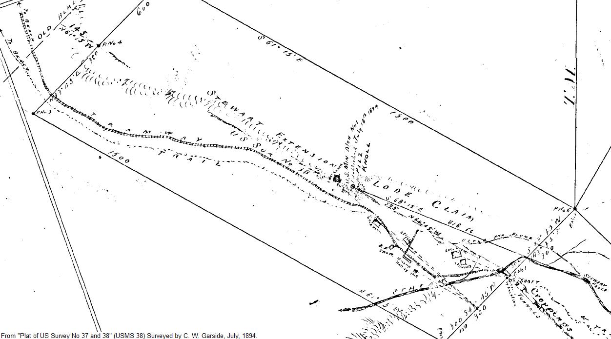
By 1896 the tramway was reportedly “all broken down”. A Mr. Doran had re-staked the claims but was found dead at the mine, his will set off another round of lawsuits. By 1912, the mine was reportedly abandoned with “tramways leading to it thicketed with new growth of alders” (source).
______________________________________________________
Sail Island or Storm Island Tram
A map from 1974 indicates there was a fox farm on Sail Island, in Stephens Passage. The map claims there was a “railroad” around the island. The island is only about 3,000ft long, or about 16 acres.
Larry Roberts reports that the tram may have actually been at nearby Storm Island, and had a model T Ford locomotive. It ran around the interior of the island and allowed the farmer to efficiently distribute food to his animals. William Abbes ran the fox farm until about 1935, then his brother in law took over until abandoning the property at the start of WWII.
______________________________________________________
It Mine Tram
The It Mine (or Reed Mine) was located on Kassan Bay and had a surface tramway to the beach. From 1908 to 1918 it was reportedly one of the largest copper producers in the area. The Alarm Mine, Dean Mine, and Eagle’s Nest claims were also part of this property. According to the 1913 Mine Inspector’s report, ore was hauled in 1-ton cars pulled by a gasoline locomotive. Another report describes this as an 8-horsepower gasoline motor. The route is sometimes referred to as a “train line”. Based on the photo below, the locomotive looks like a slightly better-made version of the one used at the Cymru mine.

Postcard photo that appears to be labeled “It Mine Alaska”. Courtesy of George Freddora.
A survey report from 1908 describes the tram as 24″ gauge, single-track, with about a 3% grade leading from an 1100ft wharf to the base of an incline gravity tram (funicular). The funicular was a three-rail type running 1225ft at a 15-30% grade from the upper end of the surface tram to a higher tunnel.
Another photo of the locomotive and cars can be found here.
This photo shows the wharf and ore bunker. This photo shows the wharf and tram from the other direction. The rail line is shown on charts until at least the 1970s, but was reported to be in ruins by the 1940s. There is no sign of the wharf from modern aerial photos. The area has been extensively clearcut, which is usually a death sentence for any artifacts or historic structures.


______________________________________________________
Herendeen Bay Railroad
Various railroads were proposed to access coal mines in the Herendeen Bay area of the Alaska Peninsula. While some of these seem to have been fantasies or investment scams, it appears that one was actually constructed around 1889. The line was in operation for only a short time, and most references to it come from the visits of the US Fish Commission steamer Albatross in 1890.
According to the reports of the Albatross, the mine was 1.25 miles from the shore, at a place the crew named “Mine Harbor”. Coal was brought to the beach “by a steam motor on a small tramway”. One of the documents mentioning this “steam motor” uses the same term to refer to steam-powered street railways or trams. Wikipedia defines a steam motor as a form of steam engine used for light locomotives. Period locomotive catalogs define a “motor” as a locomotive with cab fully surrounding the engine. These were also called “steam dummies”. This page has some more photos and discussion of steam dummies, including a few in Alaska. An example of such a locomotive used to haul coal (in Washington State) can be seen here. Another example can be seen here.

Below is an 1890 map made by the Albatross crew, unfortunately it does not show the tracks:

The Albatross report places this railroad and steam locomotive earlier than the arrival of Seward City’s locomotive in 1893, often referred to as the first railroad in Alaska (The Treadwell mine still seems to hold the actual record, at 1888). It also places it just slightly west of the Unga Island line, sometimes referred to as the “Westernmost Railroad in Alaska”.
The date the tramway and “steam motor” were installed is not given preciesely. One document lists the mine as operating from 1880 to 1904, but the Albatross report states that it had opened in 1889. Reports from Albatross naturalist C. H. Townsend imply that cuttings for the tramway grade (where he found fossils) were recently made prior to his arrival.
The Alaska Mining & Development Co reportedly owned the property around the time of the Albatross‘ visit. An 1890 article from the San Francisco Call refers to it as the “Alaska Coal Mining and Development Company”. This may have been a subsidiary of the Alaska Commercial Company, or may have sold the mine to the A.C. Co soon after staking it. Captain T.C. Hague of the Alaska Commercial Company’s vessel Dora was reportedly one of the mine’s stockholders in 1890. Later reports such as this mention that “the principal owners … are members of the Alaska Commercial Company, of San Francisco”. An article from January of 1891 reported that owners Louis Sloss and Gustav Nibaum, (founders of the Alaska Commercial Company), were planning a railroad in the area.
A newspaper piece in March of 1891 reported “sufficient rails to lay over a mile of track” being shipped on the schooner Matthew Turner to Herendeen bay for “the Alaska Commercial Company’s coal mine”. (San Francisco Chronicle). It is unclear if this was to expand the surface line, upgrade it (from wooden rails?) or to use underground. Some coal was reportedly taken to Dutch Harbor by the Alaska Commercial Co’s ship Lettie to stock the company’s coaling station there.
In 1892 the mine was reported to have $50,000 worth of improvements, including the tramway, three blacksmith shops, a boarding house and other buildings. The report notes that the company kept “losing” the coal veins, they would start out promising on the surface and then peter out or vanish in vertical faults as the tunnels went deeper. Mr. A. Barion was mentioned as a coal expert involved with the company around this time. This may have been San Francisco oil developer August Barion.
There does not seem to have been a dock at Mine Harbor, supplies coming and going had to be rowed or towed ashore. Part of the Albatross report notes that they had to send carpenters ashore to help the mine employees build a lighter (small boat) to bring the coal out, and loading took several days. Issues with screening and cleaning resulted in poor performance from dirty coal, although the Albatross engineer was happy with the quality of the coal when cleaned.
Photo of freight being landed at Mine Harbor.
Photo showing surface outcroppings of coal at Mine Harbor.
The miners had a trail to ice-free Balboa Bay on the Pacific side of the Alaska Peninsula, and used pack trains of horses for year-round access. This route was surveyed for a railroad around 1891. One source notes that the report by the Albatross‘ engineer “encouraged the owners of the property to such a degree that an engineer was employed to survey the property and lay out an experimental line for a proposed tramway to Portage Bay”. Legislation in 1890 and 1892 proposed to grant permission to the Alaska Mining and Development Company to build a railway from Portage Bay to Herendeen Bay for shipping coal. This book of 1892 references the planned line, stating that “a Corporation in San Francisco is actually building the first railway in Alaska…”. An 1893 guidebook to Alaska claims there was a 13-mile railway in existence between Herendeen Bay and Portage Bay by that year. Another visitor the following year failed to find any rails and considered the 1893 reference to be a typo.
Railroad route surveyed prior to 1896:

This report from 1908 mentions the tramway and the possibility of building more railroads to bring the coal to better harbors (Besides having no dock, Herendeen Bay would freeze up in the winters). The document says that coal mining began in 1880 (another version says 1889) by the Alaska Mining and Development Company, who dug two tunnels about 500ft total length. The report states that the coal field was abandoned in the early 1890s due to lack of demand (The two refueling stops by the Albatross comprising the bulk of the product sold). By 1893 the Alaska Mining & Development Co had reportedly shifted their attention to Anchorage Bay near Chignik, perhaps taking their railroad equipment with them.
Herendeen Bay’s coal field was reopened by C.A. Johnson (a local saltery owner) in 1898. A report from 1898 mentioned that 500 tons of coal had been taken out by the Alaska Commercial Co that year, but that it was too fast-burning for steaming purposes. The property reportedly changed hands again in 1902, but reportedly the new owners did little work and went bankrupt by 1904 or 1905. This appears to have been the Pacific-Alaska Transportation & Coal Company. An article from November of 1903 mentions this company staking claims in the Herendeen Bay area, with the intent to supply coal to Nome, the Yukon, and the government Coaling Station at Unalaska. The company was incorporated in New Jersey in July of 1902, a 1905 directory lists it as a “Coal Shipping Railroad”. The company also owned the steamer Jeanie.
The Pacific Alaska Transportation and Coal Company filed in 1903 to build a rail line from Portage Bay to Herendeen Bay (specicially “Main” (Mine) Harbor, as referenced in other filings). The existing line would become a 1.4-mile branch and another branch would serve mines at Chignik River. Officers of the company were listed as Roland Onffroy (or possibly Ouffroy), president and treasurer, Louis S. Prosner, secretary and assistant treasurer, and Charles W. Beaumont, assistant secretary. Armond Spencer is listed elsewhere as Vice President, and an article mentions the company may be related to the bankrupt Pacific Packing and Transportation company, of which Onffroy had been manager. Another related company was the Alaska Peninsula Packing company, which claimed to be building the world’s largest cannery at Herendeen Bay in 1905. Persons associated with the coal mine in 1905 included Julian M. Platz, Regiland (or Reginald) H. (or G.) Schneck, and Kenneth K. McLaren, all of New Jersey. Charles W. Jackson, a former coal developer from Chicago, was the San Francisco General Manager.
A 1903 article quotes Mr. Ouffroy as saying the Jeanie would carry material, machinery, and laborers to Mine Harbor, and that the first 1.5 miles of railroad to the mine would be built by May of 1904. The line was reported to be already graded, but no mention is made of the tracks or steam motor seen by the Albatross crew in 1890.
Some reporters seemed to think Onffroy’s businesses and investment schemes were less than legitimate. Whatever the reason, a railroad to a decent harbor never quite materialized, and the mines seem to have failed either from lack of access, lack of reliable coal veins, or both.
The mine is listed as abandoned on 1905 charts, but prospecting and other development attempts continued for some time. F.R. Philbrick and R. A. Foster were listed as engineers at the Herendeen Bay Mines around 1911. Local residents reported mining by a Mr. Foster from 1903 until 1905 or 1906, succeeded by a Mr. Cunningham who sold coal to nearby canneries until 1916. Ownership and management of the property is convoluted during its entire life span, (as was somewhat common with Alaskan investment properties).
Although the Herendeen Bay rail line is referred to in period documents as a “tramway”, I am calling it a railroad because other lines of such length are traditionally called railroads when they utilize a steam locomotive (Unga Island, etc).
The “steam motor” seems to have disappeared prior to 1903, as implied by R. Onffroy’s statements and by later reports by local residents. A 1942 visit by military geologists evaluated mine and road potential, and interviewed people living nearby. These residents were aware of coal mining in the 1903-1906 time period, but apparently did not know of the earlier operation. They reported that rails were laid along a path about 2.5 miles from the mine to the beach, and that cars were drawn by horse, no mention was made of a locomotive. The 1942 investigators found several rail wheels of 30″ gauge, the remains of blacksmith shop, and a rusting steam-powered drill rig.
A 1914 survey mentions “a railroad to tide water from the coal deposits” at Mine Harbor.
If anyone has further information on this railway I would love to hear about it!
______________________________________________________
William Henry Bay
The Alaska-Endicott Mine at William Henry Bay had a 30″ gauge railway from the adit to the beach. The mine opened around 1915 and may have initially produced some gold, then become a copper mine. The Copper Handbook from 1922 mentions that a tram was planned, and a filing by the Alaska Endicott Mining & Milling Co reported that a 1-mile tram was installed in 1924.
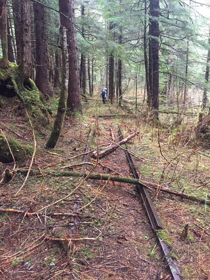
Railway at William Henry Bay. Courtesy of Mareta Bates Weed.
An article by Pat Roppel discusses the mine and mentions that an electric locomotive was used on the surface tram. Another of Roppel’s articles talks about other development at the bay, including farms, placer mining, uranium mining, and timber harvests.
Explorers with Juneau’s Hidden History reported 5 different types of rail on the line, all 30″ gauge. This included girder rail, a type often found in street tramways. The variety of track suggests that the company salvaged or purchased abandoned rail from other nearby mines as a cost-saving measure.

Girder Rail used on Alaska Endicott tramway. Courtesy of Brian Weed.
A 1951 USGS bulletin reports that “An old surface tram, now overgrown with brush, extends from the beach to the deposit”. The electric locomotive and cars were probably removed or sold to another company after the mine closed.
______________________________________________________
Sunrise Tram
The mining boom town of Sunrise (or Sunrise City) on Cook Inlet was noted as being the biggest city in Alaska in 1898. The town lasted from about 1895 to 1916, the last resident leaving around the 1930s. Today it is a ghost town, without much left but a cemetery. Various sources mention a tramway or tramroad built in 1899 to bring supplies from the dock to the town (a distance of about 3,000′). A comment posted on the ghost town website says that the tram curved along the toe of the slope just below the cemetery.
Tides are so extreme in Cook Inlet that boats would simply pull up to the town wharf at high tide, then go dry as it ebbed. A photo of two steamers sitting on the mud flats is here.
A map section showing the tramway route is below.

An earlier map showing a bit more detail (and offers an alternate name for the point North of town). I have highlighted the tram route since it was hard to see:

This document describes a walking tour of the area, and shows a historic photo of the tram on pg 4. A modern excavation photo showing the remaining wooden ties is on pg 5 (the rails were steel and were probably salvaged for use elsewhere). The tram is described as the “Allensworth and Company” tramway.
______________________________________________________
Treasure Creek Incline
An incline tram at least 3,000ft long connected the Black Eagle antimony mine to the Tanana Valley Railroad. The mine, also known as the Scrafford property, was in Eagle Creek valley below the present-day Murphy Dome Road. Ore was hoisted up the tram in 1-ton cars by a stationary 15hp gasoline engine. It was then carried 4.5 miles along the ridge top to the TVRR, either by wagon (reported in 1913 here) or by horse tramway (as reported in 1915 here).
______________________________________________________
Yukon-Kuskokwim Portage Tramways
Several small hand trams have connected the watersheds of the Yukon and Kuskokwim Rivers near the village of Nunapitchuk. They allowed small boats to cross between the river drainages without going out to the coast. An article from 2011 includes a photo and discusses repairs to the “1960s-era” tramway. Another article claims it was built by fur traders in the 1940s and says it is pulled by hand-cranked cables.

A history of the Kuskokwim River Region describes several planned and completed tramways. Three portage trams were recommended around 1912, with various proposals for location and length considered over the next few decades. Engineers recommended steel rails, which would be more expensive than wood but require less ongoing maintenance. By 1931, the Road Commission had completed two light steel trams aggregating 5,943ft in length, plus a canal. One tram was at Talbiksok River and one at Mud Lake, the routes were moved occasionally by locals as waterways shifted or silted up. Other trams may have been constructed as well.
One of the portage tramways is visible in this pre-1940 photo.
______________________________________________________
Eyak Tramways
Prior to the building of the Copper River Northwestern Railroad, there existed several small tramways at the cannery town of Eyak. This location would later become the city of Cordova. Spawning salmon were caught in the fresh water of nearby Eyak Lake, rather than the sea. Tracks led from the West end of the lake to two competing canneries at tidewater. The two parallel tramways are mentioned in an 1890 census document. It is possible there was another tramway on the East end of the lake leading to the Eyak cannery, but this has not been confirmed.
On the North side of Odiak Slough was the Pacific Packing Company’s “Odiak Cannery”, and on the South side was the Pacific Steam Whaling Co’s “Orca Station”. Surveys from 1892 refer to each company owning a “Railroad”.


A copy of a local news article in The Copper Spike notes that one of the lines was built around 1887 and was considered somewhat unique in Alaska, providing a type of “Main Street tramway” for the native town of Eyak. Goods could be delivered from ships directly to a customer’s door.
1899 photo showing the Odiak cannery with tracks to Orca Station in the foreground:

Courtesy of the University of Washington Freshwater and Marine Image Bank.
Courtesy of the University of Washington Freshwater and Marine Image Bank.
Approximate location of Eyak tramways overlaid on modern aerial photo of Cordova:

The Orca Station moved up the coast about 4 miles in 1895, and its lake tram was likely demolished soon after. Most descriptions and images only show one set of tracks and one wharf at Lake Eyak. By 1898 the US land office identified only one railroad or tramway here:
“What is designated by the deputy (surveyor) as a railroad appears to be only a tramway which is over one-half mile in length, and extends from the cannery building, fronting on Prince William Sound, to the wharf at the landing on Lake Eyak…There is also located… a railroad or tramway extending westerly from the cannery building thereon to a wharf on the coast of Prince William Sound” (from “Decisions of the Department of the Interior and the General Land Office in Cases Relating to the Public Lands” US Govt. Printing Office, Vol 26, 1898).
Photos of the tramways are sometimes mis-labeled as CR&NWRR tracks (despite the tram rails being very crooked and ad-hoc). The Odiak tram was described in 1906 as a “Narrow Gauge Short Line” run by William O’Neill and pulled by a mule named Maude.
Eyak tramway between 1900-1909.
“Old Eyak” with tram, between 1908-1910.
When construction began on the Copper River Railroad, the Odiak area became the town of Cordova and the canneries became the railroad’s port and yards. The photo below shows three rail lines running through Old Cordova. One of the original tramways to Lake Eyak is between the standing people, and is being covered over by the standard-gauge Copper River grade. A temporary narrow-gauge construction tramway is off to the side:

Courtesy of Alaska State Archives, Captain George H. Whitney Photograph Collection. PCA 300
The railroad seems to have re-used tramway components to haul supplies from the dock to the new town site during early construction. A photo in Alaska Geographic’s “The Copper Trail” shows a narrow gauge tramway running down a Cordova street, complete with a switch and a grade crossing. A similar photo (below) shows road work being done with small tramways:

Courtesy of Alaska State Archives, Captain George H. Whitney Photograph Collection. PCA 300
Several photos show the Eyak Lake end of the Odiak Tram:
Eyak Lake tram, 1899:

Courtesy of UW’s Freshwater and Marine Image Bank.
Eyak Lake tram, 1908.
Tram around 1908-1910.
The tram from Cordova to Eyak Lake seems to have been improved and become part of the CR&NWRR, it is is shown on charts as a branch line connected to the railroad as late as 1939 (and as an abandoned railroad on later maps). The Copper Spike mentions that the tram was replaced with a railroad spur in 1907, probably allowing fish to be hauled on standard rolling stock with steam locomotives.

Some additional photos of the Eyak tramway can be found below:
Cannery railroad and switch.
1908 View of Main Street
“Yeak” (sic) City
“Yeak” (sic) Railroad
______________________________________________________
Yes Bay Tramway
A fish hatchery at Lake McDonald near Ketchikan included a tramway to Yes Bay. Built in 1905, the tramway was used to haul supplies from tidewater to the lake. The tram was between 1/2 and 1 mile long, and included a donkey engine for pulling carts on steeper sections (flat sections may have been pushed by hand). The hatchery was at the far end of the lake, and had additional tramways for moving supplies between buildings.

Photo courtesy of The University of Washington’s Freshwater and Marine Image Bank, used as public domain per their copyright description.
An aerial photo from 1929 gives a good overview of the hatchery. A tramway can be seen curving from the boathouse on the lake, between the buildings, and up the river. Many boardwalks can also be seen.

Aerial from US Navy Aerial Survey, 1929. Courtesy of US Forest Service.
There is an excellent website with a lot of information on the hatchery and several photos of the tramway located here, and the author has a photo album here. A 1942 report called for upgrades to the tram including another branch 1.5 miles long between the powerhouse and the Yes Bay cannery.
______________________________________________________
Dyea Tramway
According to the City of Skagway’s land management plan, the adjacent community of Dyea (now a ghost town) had a horse-drawn surface tramway around 1898. The report mentions photos showing tracks on Broadway street, but I was unable to locate these online (Skagway also had tracks on its own Broadway St, for the WP&YRR). Other documents mention a tramway along the Taiya River to Canyon City built in 1898. (Another location called “Canyon City”, on the Canadian side of the border, also featured wooden-railed horse tramways).
A photo provided by Steve Lundin shows two small passenger cars at Dyea. These appear to be horse-drawn street cars, and are marked “Central RR Co”. A possible origin might be the Central RR Co of San Francisco, one of their surviving streetcars is in a museum.

Photo from Mark Odell collection, courtesy of Steve Lundin. Used with permission.
Steve reports that this photo was probably taken by Walter Hoglen, a partner of his grandfather Mark Odell. The two were prospecting in the Yukon in 1898 and 1899 with several others.
Mark Kirchhoff provided some additional confirmation on these tram cars, noting an article from the Dyea Trail of 19 March 1898: “Two streetcars arrived on the Humboldt from San Francisco. They will be used on the Broadway Line.” He also found a mention in the Brotherhood of Locomotive Firemen and Enginemen’s Magazine, Volume 23, pp. 412, 413. (1897) “The Dyea railroad is eight miles long, broad gauge . . . two locomotives and 20 cars have been ordered for it.” It is unknown if the locomotives ever made it to Dyea.
The Dyea tram was reportedly begun by L. D. Kinney and then continued by the Washington-Alaska Steamship Co and the Chilkoot Railroad and Transport Company. This second company planned a railroad up the Chilkoot Pass to compete with the White Pass and Yukon RR. They also developed extensive aerial cable tramways over the pass.
The horse tram had wooden rails, and originally ran from the warehouse at the long wharf (owned by Kinney) to Kinney’s toll bridge, a distance of about 2 miles. The line seems to have been extended, as an 1898 article describes a “horse tramway for eight miles” leading from Dyea towards the aerial tramways. Appleton’s Annual Cyclopaedia for 1897 describes this line as:
“…nine miles or more of horse tramway from Dyea. The rails used are of wood, topped with strap iron. The intention is ultimately to make the line a railroad.”
Other reports from 1897 describe George B. Dodwell and Hugh C. Wallace of the Chilkoot Railroad & Transportation Co as building a railroad from Dyea. The line was planned to be standard gauge and reach 8 miles in length. An article in October of 1897 reported that “a large part of the material has already gone to Alaska”. Another October piece mentions that the line would run from Dyea to Greater (or Crater) Lake. Another 1897 magazine reported “the ties are already on the ground” (perhaps referring to Kinney’s tram?) and the bark Colorado was sailing for Dyea that year with “300,000ft of lumber and other railroad materials”.
Whether or not this tramway ever saw much traffic is questionable. Karl Gurcke with the National Park Service believes that the builders were unable to get permission to build track through the Dyea military reservation. Alternate routes also ran into trouble. The Los Angeles Herald reported in December of 1897 that a fight had broken out between railroad crews and others claiming ownership of the Dyea townsite. Another report indicated that Kinney attempted to lay track through the Healy & Wilson company’s property in November, and a melee ensued in which one man shot himself in the hip. Despite such disputes, various articles in January and February of 1898 reported that a “railroad” was completed from Dyea to the Chilkoot Pass. A follow-up by the Skaguay News in February of 1898 called such claims outright lies and fraud, accusing Wallace of being a cheap romancer.
Whether or not it operated, the wooden-rail tram does not seem to have lasted long. Developers quickly tried to turn it into a full railroad, as mentioned in an article from 1899:
“The old narrow gauge tram is being torn up, and standard gauge railroad bed is being constructed along the street and out to Canyon City.” (Eugene Register-Guard (Eugene, OR), 4 Nov 1899).
The same article mentions a railroad station and tunnel being constructed at Sheep Camp. Various reports from 1899 and 1900 claimed that work had begun on a 3/4 mile tunnel underneath the Chilkoot Pass, which would allow electric standard-gauge trains to avoid the switchbacks of the narrow-gauge WP&YRR. A powerhouse was built, but ended up supplying electricity to aerial tramways instead of a traction railroad.
More articles in 1900 report railroad work at Dyea, with two miles of roadbed “graded and ready for the ties and rails”. This led from the old Dyea wharf to the west branch of the river, including trestling over the tide flats. The company also laid out a survey for the “Lynn Canal Shore Line Railway” to connect Dyea and Skagway.
The National Park Service notes “crude wooden tracks for the horse tram” constructed along Broadway street in Dyea, but supposedly not completed and “never known to be used”. Another NPS document states there is no photo documentation of the tracks ever extending past the Dyea military reservation.
Various sources also mention one or more surface (incline) tramways running up the Chilkoot Pass from the Scales to the Summit, powered first by horses, then steam, then gasoline.
Despite much supposed construction work, a “real” railroad never seems to have materialized at Dyea. Kinney and Wallace were still planning and promoting such a project in 1900. The White Pass & Yukon Railroad was completed from Skagway to Whitehorse that same year. Dyea quickly lost all freight traffic and most of its population, and was abandoned soon afterwards.
______________________________________________________
Matanuska Valley Branch Lines
Between 1914 and 1946 The Alaska Railroad operated a line up the Matanuska Valley as far as Chickaloon, serving coal mines in this area. Two branch lines connected this route to mines in the vicinity of Wishbone Hill. Small 0-4-0 saddle-tank locomotives operated on these lines, hauling coal from the mines at Eska, Jonesville, and Moose Creek to the main line.

A more detailed map showing the Moose Creek branch reaching farther around Wishbone Hill is here.
The branch lines began as narrow gauge, with parts upgraded to standard gauge later. The first customer may have been the Doherty Mine, less than a mile from the standard-gauge Matanuska branch. Prior to 1917 it was described as using a 35hp steam locomotive on a 3,000ft narrow-gauge line to bring coal to Moose Creek. A 1916 survey labels this as “Coal Mine tram road”.
Early construction of the narrow gauge track from Moose Creek station is mentioned here. The lower section was reportedly upgraded to standard gauge in 1926. By the 1940s the Moose Creek branch was standard-gauge as far as the Premier Mine, then continued as narrow-gauge to the Wishbone Hill mine. Sutton to Eska was reportedly narrow-gauge in 1920, and later widened to standard gauge.
Abandoned standard-gauge track between Palmer and Chickaloon:

This page mentions that narrow-gauge Tanana Valley Railroad cars and construction cars were used on the Moose Creek branch, with at least three narrow-gauge steam locomotives. The Alaska Railroad and predecessor companies used narrow-gauge track and small locomotives for preliminary construction along the main line, so they had a supply of such equipment on hand.
Historic photos:
Locomotive at Eska mine.
Saddle tank locomotive at Eska.
Narrow gauge locomotive on a standard-gauge flatcar at the Anchorage shops
The Evan Jones mine at Jonesville opened in 1920, with the government mothballing their Eska mine to avoid competition with private business. A fire at Jonesville in 1922 caused Eska to re-open briefly. A flood washed out the track to Eska and damaged the mine in 1932, so a new railroad spur was built to a new mine site and new access tunnel across the creek. It is possible that the track was upgraded to standard gauge at this time. A BLM document reports “The original narrow gauge track ran from the top level of the coal processing facility, up the east side of Eska Creek. The standard gauge track ran from Sutton, along Eska Creek, to the mine facilities and to the main portal.” Eska again re-opened after another fire at Jonesville, then operated during WWII for military fuel. The area was strip-mined in the 1950s.
Rail tracks were reported at Coal Creek, on the South side of the Matanuska River near Chickaloon. This area was prospected by the US Navy in the 1920s, and the Hecky Mine operated here from 1925-1930. A photo of the area can be found here. It is not clear if the narrow-gauge tracks were only for ore carts or if they ran to the main railroad line.
The Matanuska branch closed when the mines became uneconomical (oil had begun to replace coal, and the Healy coal mines were more promising).
Current end-of-track on the Palmer branch of the AKRR:

Today, part of the grade is a rail trail. At least one of the narrow gauge locomotives was converted to standard gauge for use as a switcher, it is now on display in Anchorage. Another locomotive is in Palmer, and at least one other is in private ownership. This page notes that an unknown number of 0-4-0 narrow gauge locomotives were used by the AKRR and never formally documented. After retirement, some of them were disassembled and used for water tanks, air compressors, or other purposes. A few photos of remaining bridges along this spur are here. Another abandoned bridge can be seen here. Some abandoned rolling stock dumped in the river is discussed here.
______________________________________________________
Shumagin Mine
Located near the Apollo Consolidated Railroad, this line is referred to in 1897 as a “Railroad” by the same surveyor who visited the Apollo Consolidated mine and surveyed their steam railroad. In a 1940s government report, it is referred to as a “tramroad”. The line ran about 1/2 mile from Baralof Bay / Squaw Harbor, past the stamp mill to the Union mine claim. It reportedly had a value of $1,500 in 1897. The mine was known as the “Choumagin Consolidated”, operated by the “Choumagin Mining Co” (an apparent alternate spelling of “Shumagin“).
One of the promoters in 1888 was George W. Sessions, who spent time attempting to sell the property to US and European investors, despite mixed reports on the value by various experts. Sessions was also involved with the Sitka mine on Unga island.


This railroad has the dubious honor of being one of the few (if not only) railways to be stolen by pirates. In 1891 the steamer Hattie Gage of San Francisco suffered a mutiny, the first mate and two men named Libbey seized command. The captain was put ashore and the crew set out on a “piratical cruise“, raiding seal rookeries, vacant supply depots and villages, and a “Greek Church” (probably Russian Orthodox). At Squaw Harbor, the pirates stole material and lumber worth $7,000 from the Shumagin mine, part of the lumber being a “railroad for carrying ore” (likely wooden tram tracks). The stolen railroad was reportedly carried to nearby Coal Harbor and sold to another mine, the pirates helpfully setting up and laying the rails. Other reports indicate that the Libbey brothers may have actually been named Tibbey, and were part owners of the Coal Harbor mine. The ship was seized by the authorities in October for having false paperwork, and news reports mentioned George Sessions suing the crew for theft of his railroad.
These mining claims have been test-drilled in recent times by developers of the former Apollo site, and the railroad/tramroad grade has been turned into a dirt road (which extends all the way to the Apollo Mine).
______________________________________________________
Assorted Marine Ways
(I would like to thank Alaska historian Bob King for clarifying and providing information on some of these systems).
Marine ways and marine railroads were common features of Alaska canneries. They were used to store boats and scows over the winter, to repair vessels, and to access deep water at various tides. In some cases they have even been used for airplanes or airlines operating multiple planes.
In locations with steep shorelines, they typically only ran a few hundred feet. In other locations with shallow beaches or mud flats, they were more extensive. Usually a marine way consisted of wooden rails (sometimes metal capped) on which boats were directly slid or rested sideways on wide carts. A marine railroad usually had metal rails and a cart which cradled the hull, typically facing parallel to the rails. Both these terms are sometimes used interchangeably for various versions of each system. Some systems had side tracks or laterals for storing and shuffling multiple vessels. Marine ways for winter fish scow storage at Funter Bay are documented here and here.
As mentioned in the Lockanok section, canneries in the Bristol Bay area fought a constant battle with tides and mud flats. With tides in excess of 20 feet, several canneries constructed extensive marine ways to reach deep water. One such marine way is shown as a railroad or tram on topographic maps at the Nakeen cannery on the Kvichak River. This cannery operated until 1966. As with many such facilities, it was powered by a stationary steam donkey engine which pulled a cable. Some canneries later switched to gasoline-powered winches. Another example is seen at the bottom of this photo of the Koggiung cannery. Other extensive marine ways occurred at the Columbia River Packers Association “Creek” cannery on the Nushagak and the Alaska Packers Association “Diamond J” cannery on the Kvichak. The latter were used to store tally scows and other support vessels long after the cannery was shuttered following the 1952 season.
At least one marine railroad at Naknek had a turntable and two branches:

______________________________________________________
Chichagof Mine Tramways

Courtesy of Alaska State Archives, Winter & Pond Collection, ASL-PCA-87-415
The large Hirst-Chichagof mine and company town of Chichagof in Southeast Alaska had some short mine-gauge tramways running between workings and ore dumps. A longer surface tram ran from the near-shore adits and the lower aerial tram stations, through a snowshed, to the sawmill and to the powder magazine about 1/2 mile from the wharf. Tracks also led along the wharves and between camp buildings.

Several photos showing tramway operations are below:
Chichagof “Main Street”.
Framing shed and sawmill.
Tracks on wharf.
This mine had a large hydroelectric power plant several miles away, and the trams were likely powered by electric locomotives. Underground haulage was originally by “mule train” in the long main adit, later by “electric tramming”.
Some tramways also existed on the other side of the mountain at Kimsham Cove, part of the same mine property.

The Chichagof mine had various re-opening and re-processing (of old tailings) attempts up through the 1980s, some of which were stymied by fires and other setbacks. Today you can still find some of the equipment on-site, including battery mine locomotives and rolling stock, as seen here.
______________________________________________________
Saint Lawrence Island Tramways
A tramway or small railroad was apparently built by the U.S. Air Force at Gambell on St. Lawrence Island around 1946. This served the Aircraft Control and Warning Station at Northwest Cape (an early surveillance station used during the Cold War). After the spy facilities moved to the other end of the island in the 1950s, the military buried most of their surplus equipment (a common procedure which causes ongoing issues for local water supplies). Some sources mention a tramway to, or up, Sevuokuk mountain. This could have been partly an aerial cable tram.
In 1951 the Air Force began construction of the Northeast Cape radar station and White Alice communications site. A rail tramway was likely built from the beach to the construction site, approximately two miles. Aerial photos appear to show a loop at the beach, and a one-mile branch off the main line leading to gravel pits. This line probably used one or more small gasoline locomotives to haul construction materials and gravel fill for roads. After construction was completed, the rail line was replaced with trucks (the tram would have initially been the easiest way to cross the spongy tundra before a good source of road gravel was reached). The tracks and rolling stock were probably shipped to another construction site or back to the lower 48 once the roads were finished. As at other sites, an aerial cable tramway led up the mountain to the radar domes.
Photo showing “Railroad Tracks on Saint Lawrence Island”. This is probably the switch at the beach loop at Northeast Cape.
Formerly Used Defense Sites description of Norton Sound area installations.
______________________________________________________
Dutch Harbor / Unalaska Tramways

Courtesy of Alaska State Archives, John Romero Photograph Collection, PCA 342.
At least three surface tramways existed in the Dutch Harbor area prior to WWII. In the 1870s the Alaska Commercial Company began fur harvesting operations in the Aleutian Chain, and established a trading post and supply depot at the village of Unalaska (sometimes called Iliuliuk in older documents). This property included a coaling station, with coal bunkers about 1/4 mile from the wharf. A tramway allowed coal and other materials to be moved around the property. A 1903 guide described “Tram cars and wheelbarrows at wharf” as the loading system there. A 1911 photo shows tracks leading to the wharf. An inclined trestle seems to lead from a loading bin on the dock towards coal storage areas in this photo. Another photo shows the tracks and loading bin in a different position on the wharf. This photo may help explain the moving tracks, it appears to show a pile of prefabricated rail sections, similar to a Decauville arrangement. The rails may have been assembled and moved around as needed, then stored when not being used, like a very large toy train set.

By the 1920s, oil was replacing coal as the preferred steamship fuel, and the coaling station was closed. The tram rails through town seem to have stayed in place for some time, as the wooden boardwalk they were built into was a main route between the Alaska Commercial Co’s property and the town of Unalaska. A photo from 1917 shows the “street” with rails in it. This photo from 1936 shows the tramway/boardwalk, describing it as “The only entrance to the town of Unalaska”. A similar photo shows the tram rails apparently removed or planked over where they meet the wharf. A 1941 survey shows the tramway passing the Coast Guard hangar and tennis courts, but by 1978 it is marked “concrete sidewalk (old tramway)”.

Another 1/4 mile tramway was across Iliuliuk Bay on Amaknak Island. This was installed around 1914 to support construction of a Navy radio station. A photo of this tramway seems to show a cable between the rails, cars were likely winched up the steeper sections by a stationary engine.

A third tramway ran from the North American Commercial Co’s wharf to warehouses and coal dumps. Inclines led to elevated rails allowing coal to be piled up for later use.

Courtesy of Alaska State Archives, John Romero Photograph Collection, PCA 342.
This tram had two tracks down the approach from the warehouses, and a loop track and siding on the main wharf. A 1912 photo (below) shows the tracks and a docked coal supply ship. Coal was imported from Australia by a private contractor.

Courtesy of Alaska State Archives, John Romero Photograph Collection, PCA 342.
This facility was transferred to the Northern Commercial Co sometime before 1918 and then sold to the US Navy in 1940, becoming the Dutch Harbor Naval Operating Base. The tram rails disappeared from the wharf prior to the 1940s. The area previously occupied by coal dumps became a tank farm once oil-fueled ships became common.
During WWII there were several small tramways built to reach fortifications at military sites around Dutch Harbor. These were typically very short, cable-hoisted inclines. The longest was 2,400ft at a 52% grade serving a radar station at Cape Prominence. Some example photos can be found here and here.
Rails and a loaded tram car on one of the docks can be seen here.
A 1/4 mile tramroad was reported from the Hague gold mine to a stamp mill on Captain’s Bay prior to 1904. Located on the West side of Pyramid Peak behind Dutch Harbor, this mine was also known as the Huntsville Group and Pyramid Peak mine. It was reportedly started around 1900 by prospectors delayed on the way to Nome, and never produced much. The underground workings included several hundred feet of shaft and tunnel. The type and motive power of the reported tramroad is unknown. Based on the steep topography of the location, it may have been a cable incline.
______________________________________________________
Afognak Hatchery Tram
Similar to the Fortmann Hatchery, the Afognak Hatchery was built to support commercial fishing operations and ensure fish stocks for the future. It featured a 3-mile tramway between the hatchery and a nearby cannery. The track, apparently made of wood, followed the Afognak River from Afognak Lake to Afognak Bay on Afognak Island (a very creative series of geographic names!)

Photo Courtesy of the University of Washington Freshwater and Marine Image Bank.
The hatchery was closed in the 1930s and became a recreation camp for military personnel until the 1960s (Kadiak.org reports that it was used as a floatplane base during WWII). It is still shown as a recreation camp on topo maps, along with a dirt road following the tramway grade. The buildings and bridges (including a rare covered bridge) on the grade appear to be gone. This document reports that the tramway was installed in 1914. It also mentions that the covered bridge was built in 1929 and destroyed in the 1964 earthquake. A community named “Litnik” is shown near the bridge on various maps, and the Afognak River is called the Litnik River in the above photo.
A map from the 1940s shows the tramway somewhat shorter, but other accounts say it ran from the canneries at Rivermouth Point to the hatchery.

______________________________________________________
Big Harbor Mine Tramway
A copper deposit discovered around 1902 in Trocadero Bay led to the development of the Big Harbor Mine. In 1908 the Northland Development Company, managed by P. A. Tucker, acquired the property. Other officers of the corperation were Ansel B. Hill and C. D. Calhoun, both of whom may have worked for lower-48 railroads in the past. Various reports mentioned that the company planned a tramway with a locomotive at Trocadero Bay. The Engineering and Mining Journal from May of 1908 reported that “A locomotive has been purchased” by the company.
Mine workings were in two locations, the West adits and shafts were up a steep hill from the wharf, necessitating an aerial tramway. The East workings were accessible by a more gentle slope, where a rail tram could have been used. Various authors including Pat Roppel in Rich Earth report that Tucker used a 2400′ aerial tramway to the mine (likely the West workings). Other documents mention an 1800′ surface tramway planned, but not yet built by 1914. Tucker and Co may have reorganized later as the “Northland Copper Gold Group” around that time. In 1915 they leased the operation to the Southeastern Alaska Copper Corporation, who reportedly built a 1700′ horse-drawn surface tramway by 1916. A 1946 US Bureau of Mines report mentions a “log trail” which could be a corduroy grade or plank road. A map of the mine locations and trails is here.
While the locomotive mentioned in 1908 could have been a battery unit for underground work, the relatively small extent of the tunnels would tend to suggest hand tramming underground. Another possibility is a home-built steam logging locomotive reportedly shipped to Alaska from Washington State that same spring.
The Allen-Sherman Lumber Co of Thurston County had a mill 2 miles North of Littlerock, WA, with about a mile of track. This appears on pre-1910 maps as the A&S or Allen Sherman Logging Railroad. Owners of the company were Bertram Edward Sherman and Charles Allen. An “E Sherman” is listed as the officer in charge of railroad traffic in the Feb 1908 “Official Railway Equipment Register”. A photo dating from around 1902 shows the homemade steam engine of “Allen’s Mill Railroad”, reportedly constructed from a repurposed donkey engine and a boiler which had come from China.
The steam locomotive was reportedly sent to Alaska after Allen & Sherman ended their operation. This seems to have been in March of 1908, when the sawmill burned down. Local news claimed the partners would rebuild, but Bertram Sherman and family moved to Idaho after the blaze, and the company seems to have closed. As the Northland Development Company was formed in Seattle in the same month that the mill burned, they could have acquired the locomotive and other equipment as surplus.
While much of this is conjectural, multiple sources state the A&S locomotive went to Alaska, and multiple sources state that Northland bought and planned to use a locomotive at about the same time. Whether the locomotive was ever used on track at the Big Harbor Mine is another story. It may have served as a stationary steam engine to run the aerial tramway or other equipment, as a 1914 report mentions the mine had “steam power”, but that the surface tram was still in the planning stage. This could also explain why there is no apparent record of such a unique steam locomotive in Alaska.
Despite many years of prospecting (into the 1990s) and occasional reports of small ore shipments, there does not appear to have been much production from the Big Harbor Mine. Pat Roppel has a good write-up on the mine’s history, and describes remains of the cabins and aerial tramway found in the 1980s.
______________________________________________________
Harris River Tramway
A survey from 1919 shows a tramway from the Harris River Mine leading towards the shore. Later maps show a trail following this route for about 1 mile between the mine and the mouth of the Harris River. The mine was at various times also known as the Julia, the Dunton, the Kassan Gold Co, and the “Rodgers” or Rogers mine. The mine and mill were powered by a hydroelectric dam on the Harris River, and the tram may have been driven by an electric locomotive. The mine operated into the late 1920s but experienced power shortages in the mill and challenging geology in the shaft, leading to its closure. An article from 1920 mentions a surface tram to tidewater from the mine.


A photo from around 1920 shows the tram and two people sitting on a car of some sort:

Courtesy of Alaska State Library, E.G. Riebe Photograph Collection, PCA-573
______________________________________________________
Thorne Arm Tramways
Near the head of Thorne Arm, South of Ketchikan, were several gold mines in close proximity. These included the Sealevel, Goo Goo, Gold Banner, and Burlesque properties. The original Sea Level claims were staked around 1897, but the initial mill shut down around 1903 due to lack of ore. Other claims were staked in following years, with significant work being done at the Gold Banner mine in the 1920s and 30s by the Alaska Ketchikan Mining Company. According to a USGS report, the Gold Banner mine had “significant improvements… including a hydro-electric plant, assay office, wharf, rail system, and mill”. An accompanying map shows approximately 2000ft of “Rail line” from the shore to the Gold Banner claim, and shorter trams to nearby claims. Another geologic study mentions a tramway following Gokachin Creek from the Gold Banner glory hole (open pit) to the mill. By 1936 the mine’s equipment was reportedly in poor condition.
A 1945 photo published in Alaska Geographic shows a gas locomotive based on a Fordson Tractor parked on the Sealevel mine wharf. The design looks very similar to the Fordson locomotives used at Cobol and Nome. An earlier report from 1931 also mentions this Fordson locomotive, stating that the track was 36″ gauge of 40lb rails, and the train consisted of seven 1-ton ore cars.
A 1950 study proposed re-opening the mines and building an electric railroad along the shoreline from the mine to a deepwater wharf.

______________________________________________________
Nome Placer Tramways
Several placer mines in the Nome area used small railways or tramways to move gravel around. While smaller operations used horse or man power to move single ore cars, several seem to have used locomotives of various types.
A 1905 report on Alaska mineral resources mentions that:
“Two steam shovels were in operation on different properties on the east side of Nome River near Irene Creek. They were equipped with tracks and cars for transporting gravel from the pits to sluice boxes and employed small locomotives to move the cars”
One of these properties could have been that of “Con. Kelly”, who owned the “Dora Association Bench Placer” pit at the mouth of Irene Creek, among other claims. Such surface placer mines were very common in this area. Many had small tram lines which would be moved to follow the current working area.
A newspaper article, also from 1905, mentions that tracks were being laid near the mouth of Irene Creek (perhaps related to a dredge), and that self-dumping ore cars were being used.
Steam shovel with tramway near Nome:

Another photo of a steam shovel loading ore cars near Nome is here. Note that the shovel is a railroad type on larger-gauge trucks, but only has a few feet of track under it. Such shovels were sometimes moved by leapfrogging short pieces of track ahead of them as they progressed through the placer pit area. Another such steam shovel on a short track is seen here, in this case wagons are hauling away the dirt.
Very extensive network of tram tracks in open-pit placer mine near Nome:

A variety of small ore carts on tracks are seen in an open-pit placer mine near Nome in this photo. Such tracks would have been moved frequently as strip mining progressed up the river valleys. Ore carts on multi-level tracks in an open cut mine are seen here.
More steam shovel and tramway activity on Anvil Creek:

Tramways with ore cars on Anvil Creek:
A dredge on West Creek in the Shovel River valley near Nome operated on light railroad tracks between about 1908 and 1911. Owned by a Mr. Mulligan, this dredge operated where a lack of water precluded the usual floating dredge. Several “land dredges” of this type were reportedly tried in different parts of the Seward Peninsula with varying degrees of success.

Courtesy of Alaska State Archives, B.B. Dobbs Photograph Collection, PCA 12
A small locomotive built from a Fordson tractor is (or was) displayed alongside a steam shovel in Nome. A photo from the 1970s is here. This engine was used by the Alaska Road Commission on the Wild Goose Railroad / Nome-Shelton tramroad, as seen here. Similar such ad-hoc locomotives could also have been used on the mining trams. Today the Fordson seems to have been pushed closer to the beach and is sinking into the gravel.
H.K. Porter records suggest that two standard-gauge steam locomotives were shipped to Nome around 1905. These were apparently not part of the standard-gauge Council City and Solomon River railroad, and may have been used for placer mining operations.
A 1905 advertisement from the Davenport Locomotive Works states that one or more of their locomotives was operating at Nome, AK, and that shipment to AK was within the previous two years. Company sales records fail to show this, so the sale(s) may have been via a distributor or through a corporate office “Down South”.
Other information (provided by John Taubeneck) lists several 250v electric trolley locomotives used in the Nome area by the Pioneer Mining & Manufacturing company. These were 30″ gauge.
Other reports indicate dredge-related tracks and rail cars “about regulation size” (meaning standard gauge?) at Irene Creek around the same time. Later reports indicated that steam shovels and rail cars were not found to be cost effective for placer mining, dredges being cheaper.
______________________________________________________
Niblack Tramways
A survey from 1905 shows several tramways leading inland from near the shore at Niblack Anchorage. The Mines Register from 1906 reports a double-tracked, gravity operated tram (perhaps a type of funicular) with 700′ long double-tracked ore dock “similar to those of the great iron ore shipping ports of Lake Superior”. Small versions of such docks were fairly common in Southeast Alaska, the general design being a railway or tram track along the top, from which ore was dumped into elevated bins or “bunkers”. Ships would tie up below the bins and ore would be dropped into the holds. A model example of such a dock, of the size found in Alaska, is seen here. Another example (at Iyoukeen Cove) is seen in the background of this photo. An example of the much larger Lake Superior ore docks can be seen here.

The Niblack Mine has recently been investigated for reopening. Some modern photos of the area are here, and a map of modern infrastructure and tunnels is here.
______________________________________________________
Davidson’s Landing Tram
The location known as Davidson’s Landing on the Kaviruk River, Seward Peninsula, was a transshipment point for freight into the Kogaruk mining district. A wharf on Mary’s Slough connected via tramway with warehouses of several companies. This was the head of navigation on the Kaviruk from the ocean. From Davidson’s landing, goods were taken 40 miles by wagon road to Taylor Creek.

The survey notes from describe this as a “tramway 2ft gauge, over level land”. A switch divides the line between the Taylor Creek Ditch Co’s warehouse and a track to the “Kougarok Mining & Ditch Co’s yard”. Both companies jointly owned the landing dock and tramway. The total length of the tramway is not indicated on the surveys, but was possibly less than 1000ft.

The location is named after Engineer J. M. Davidson, who was was responsible for several major waterworks projects in the Nome area, and later in the Fairbanks area (including the complex Davidson Ditch project). Most of these ditches supported dredges or hydraulic placer mining operations.
______________________________________________________
Silverbow Basin Mining Co / Groundhog Mine Railroad
Assorted placer (surface gravel) mines operated in the Silverbow Basin area behind Juneau through the 1880s. In 1889, Thomas Nowell consolidated a number of claims and formed the Silver Bow Basin Mining Company. He excavated a large open pit mine near Gold Creek. To keep the pit from flooding, and to catch any missed gold, Nowell dug a 3,400ft long tunnel which served as a drain and as a giant sluice box. Riffles installed in the tunnel caught gold as it settled out of the flowing water. The operation ceased around 1901 due to legal issues, then continued under various other operators and lessees until flooding and lower production shut it down around 1911.
Around the same time, Nowell began building an aerial cable tram to his Groundhog claims high on the mountain above the Perseverance mine. This tram led down to the upper end of the placer pit tunnel. The Juneau Alaska Free Press mentions tramway surveying and construction as early as 1888. A photo shows towers for the aerial tram. In 1892 Nowell built the “Red Mill” near the lower end of the placer tunnel, and used a railroad through the tunnel to haul ore to the mill. One report mentions that the tunnel, track, and sluices were all completed in 1891, and that the railroad was about 1 mile long. The gauge was about 22″. The Groundhog mine operated until about 1895, then had minimal work done until it was purchased and consolidated into the Perseverance mine around 1911. A map of some of these mine and mill locations can be found here.
Photo showing railroad tracks running into the placer tunnel (under building in foreground). The same building can be seen under construction in the photo of the Groundhog aerial tram.

Photo showing the downstream end of the Placer tunnel. Two trestles emerge from the tunnel area, the foreground trestle seems to carry water to further sluice-box structures, and the other could be the path of the railway to the Red Mill:

Courtesy of the Juneau-Douglas City Museum, JDCM2005_01_017B.
It appears that Nowell used a 3-ton steam locomotive newly-built by the Risdon Iron Works to haul ore from the Groundhog mine through the placer pit tunnel. An article from July 20, 1893 states that “A three and a half ton locomotive has been ordered by the Nowell Gold Mining Company to be operated in Silver Bow Basin. It will haul ore cars through the long tunnel to the 20-stamp mill now being erected.” (per Bob DeArmond). A 1902 railway journal mentions a Risdon locomotive being purchased “about 1884” which is likely a typo, as this would predate Nowell’s 1885 arrival in the state.

The California State Railroad Museum has a blueprint of a geared Risdon locomotive from April 3 of 1893, built for the Nowell Gold Mining Company. Construction No. 9281 was an 0-4-0 with 5×6 cylinders in a rare center-mounted position under the boiler. The 22″ diameter wheels were set on a longer wheelbase (6′-4″) than most other small locomotives. The blueprint shows an open cab and what appears to be a small saddle tank.

Courtesy of the California State Railroad Museum
Map showing approximate railway route through placer tunnel (adapted from http://www.juneau.org/archive/pdfs/20110412092245.pdf):

The Risdon locomotive and rolling stock were moved to Sheep Creek sometime between 1895, when Thomas Nowell bought the Silver Queen mine, and 1897, when the first Sheep Creek railroad was completed. It was abandoned in a ditch near the former mill location and lost its boiler. In 2016 the remaining parts were moved to the nearby Alaska Gastineau mill tour for display.

SONY DSC
The placer pit tunnel may have presented air quality issues when running a steam locomotive through it, although it seems to have been well built for such work. The tunnel was 10ft wide by 9ft high, and had at least one shaft (some sources say two) to provide ventilation. The branch of Gold Creek flowing through the tunnel would also have helped maintain a constant air current.
Nowell Placer Tunnel and railroad in 2013:

Photo courtesy of Brian Weed, used with permission.
The placer pit tunnel still carries part of Gold Creek, although its portals are somewhat decayed. Geologists have commented that a collapse of the tunnel would block the outlet of the 100ft deep placer pit and form a new lake in Silverbow Basin.
______________________________________________________
Chignik Tramways
Various short tramways operated in the Chignik Bay area, with several longer railroads proposed but not built. One remaining tramway leads from a former cannery to a pipeline flume. Originally this track ran from the deepwater wharf at Anchorage Bay, through the town of Chignik to the nearby hills (about 1/2 mile total). The wharf end of the tram was for loading freight and coal at the cannery dock (later the “Oil Dock”). The line out of town follows a pipeline towards the cannery water reservoir. Modern photos of the rails are on this page. Another photo of the rails leading into town is here.
Tracks on wharf at Chignik (the man is just stepping from between the rails).
Wharf with rails barely visible running along it.
Another view showing tracks on wharf.
In 1912 this cannery was run by “George H. George” of the Columbia River Packers Association. Later it was known as the Northwest Fisheries Co, and by the 1930s it was owned by the Alaska Packers Association. In the 1960s it was known as the APA’s “Diamond C” Cannery. Today it is owned by Trident Seafoods. The rails no longer run to the wharf, as forklifts are used to move fish totes around.
Several coal mines existed on the North shore of Chignik Bay from about 1893-1915. One of the earliest was started by the Alaska Packers Association in 1893, with adits on the Chignik River at the head of barge navigation (this location is now a fish research station). Coal was loaded from ore carts into barges at the mine, then brought to the company’s cannery at Anchorage Bay for use in steamships and cannery boilers (the APA burned about 600 tons per year). The other mines also brought their coal to Anchorage Bay for loading onto ships, as none had decent deepwater harbors.
A proposed railroad would have connected these mines to a deepwater wharf at Portage Bay. There may have been several bays with this name, at the time the “Portage Bay” closest to Chignik was also known as Dorenoi Harbor or Kuiukta Bay. “Portage Bay” is also described as a potential port for the Herendeen Bay mine, and there is a Dorenoi Harbor near that location as well.

The Alaska Mining and Development Company, original developer of the Herendeen Bay mine and railroad, was apparently active in the Chignik Area. Several sources mention their arrival in 1893, after the Herendeen Bay deposits proved unsuitable. A 1903-1904 report claims that this company opened the Chignik River mine (elsewhere attributed to the APA). Other sources claim their mine was at Anchorage Bay, although it is more likely this was the coal bunker and wharf location. Another report mentions that due to disputes over back pay in 1904, “A considerable quantity of lumber, rails, tools, hardware, etc., landed at Portage Bay, was never taken to the mine” (This may have actually been Balboa Bay). It is possible that the small “steam motor” formerly used at Herendeen Bay was transferred to the Chignik area around this time. Reports from Herendeen indicate that the rail line there was using horses by 1903-06
Several companies claimed to be planning a railroad from Portage Bay to Herendeen Bay, with branches to Chignik, but a direct connection between Chignik and Herendeen would have been unrealistic due to glaciers and terrain. It is likely that some confusion arises from changing geographic names, and multiple bays with the names Portage, Dorenoi, etc.
Although I have yet to find any maps or photos of extensive trackage in the Chignik area, several photos do show rails for ore carts and loading operations.
Mine tunnels and ore cart tracks.
Chignik Villagers next to tracks on dock.
Another photo shows a “tramway or walkway” in the Chignik Lake area.
______________________________________________________
Ketchikan Creek Tramways
Several tramways ran from downtown Ketchikan to nearby mines and lakes in the first half of the 20th century.

Courtesy of Alaska State Archives, Alaska Lantern Slides Collection, PCA 208-221
Around 1899, “Colonel” John Shoenbar discovered copper and gold deposits near Laskawanna creek. Shoenbar was apparently something of a con man, and never held actual military rank. He began developing the property and attempted to attract Eastern investors. By 1904 there were approximately 28 mining claims forming the Ketchikan Consolidated Mines Co, encompassing most of present-day downtown Ketchikan and the surrounding hills. In May of 1904, the city council granted permission for Shoenbar to build a tramway through the city. A right-of-way 10ft wide (elsewhere stated as 15ft) ran from the dock (or the Spruce Mill), up Market Street (now Mission Street) across Cedar and Helm, to Bawden, up the hill to Park Avenue and Harris Street, along Ketchikan Creek, then up what is now Schoenbar road (spelled differently than the original name) to the main adit at present-day Peyton Place.

“Tram to Schoenbar Mine”, Courtesy of Alaska State Archives, Alaska Lantern Slides Collection, PCA 208-220
The mine workings are mostly under residential neighborhoods today, and have reportedly been sealed. At least one tunnel was used as an air raid shelter for a nearby school during WWII.
This line is described as a “plank tramway”. This could have meant wooden rails or a wooden trestle/walkway with steel rails. A report from July of 1904 notes that the construction involved “considerable blasting of rock and felling of trees”, which caused Ketchikan Creek to become narrower at some points.

According to a 1907 article in the Boston Evening Transcript, the infrastructure included “An elevated Tramroad, one and one-quarter miles in length, leading from the foot of Market Street, Ketchikan, and running through the center of town site of Altamont” (Altamont was apparently a company townsite claimed, but possibly never surveyed). In 1907 some of the claims were listed as filed by James A Davis. Company directors in 1907 were Davis (president), Augusts C Hone (VP), Henry N. Fisher (secretary treasurer), John B. Castleman, Augustus E. Scott, John Shoenbar, and Charles E. Hale.
The property apparently did not have much work done after 1904, although Shoenbar continued to promote it. The metals market went downhill around 1907, and Shoenbar reportedly skipped town around 1911 to avoid creditors.
An adjacent tramway belonged to the Ketchikan Light, Power, and Water Co, AKA the Citizens Light, Power, and Water Co, later known as Ketchikan Public Utilities or KPU. A brief history of the utility company is available here. A photo of the tramway appears to show wooden rails, the tram was built as part of a wooden water pipeline / flume from Ketchikan lakes to the city powerhouse. Water was also used in various sawmills near Ketchikan Creek. Part of the tram route seems to have been upgraded with steel rails later on, although descriptions from as late as 1959 call it a “wooden tramway”.

Tram with hand pump car and water pipe, not identified but possibly from Ketchikan pipeline tram. Courtesy of Alaska State Archives, Alaska Lantern Slides Collection, PCA 208-220
The CLP&W Co tram originally ran from Ketchikan Lake into downtown, crossing Ketchikan Creek several times and ending either at the company warehouse on Park and Bawden, or at the main office on Mission between Front and Main streets. The Shoenbar / Ketchikan Consolidated tram ran past the warehouse on its way to the docks, and it is possible that it connected to the CLP&W tram at this point, rather than both having tracks down Bawden towards Mission. Later the tram was shortened, ending at the power plant near City Park. This alignment is shown on topo maps through at least the 1950s.

This photo shows what could be a tramway on a wooden trestle/walkway. The details are hard to make out.
Nearby Whitman Lake also had a tramway prior to the 1970s, when it was removed to make room for new pipes to the lake. The original dam was built for the New England Fish Company’s cannery. The water pipeline currently serves both a power plant and a fish hatchery. The tram would have been an incline about 1/2 mile in length. A photo from construction of the New England Fish Co seems to show wooden rails in the foreground.
An interesting side note concerns a 1930s “railroad” operating in the Ketchikan City park, also along Ketchikan Creek. This park, developed as a depression-era economic booster and “industrial fair”, included a small tourist railroad. The meandering loop track, laid in 1937, was about 1000ft long and included bridges over small streams from the power plant tailraces, as well as a “tunnel” which also served as the train garage. The train had a gasoline engine styled as an art deco steam locomotive, along with a tender and two coaches. This railroad ride lasted until 1941, when the fairground became a CCC and military camp. The rails were sold to KPU for use on the Ketchikan lake tramway.
Map showing tramway routes in 1907:

______________________________________________________
Speel River Project
Around 1915, a mining engineer and entrepreneur named Patrick Eugene Kennedy (sometimes given as Eugene Patrick Kennedy) set out to build a hydroelectric and chemical plant at Speel River. He and partners Raskovich and W.P. Lass had previously been involved with the Treadwell mines, including work on the Nugget Creek power plant and tramway. A corporation known as the “Speel River Project” was filed in California in 1915. Consulting electro-chemical engineer was J. W. Beckman.
The plan was to use cheap hydroelectric power to create a modern industrial center, performing everything from smelting to electrolysis to fertilizer and explosives production. An article by W. P. Lass describing the scheme can be found here. For various reasons the plan did not get very far, including the cost of shipping and the lack of resources in the area. Kennedy and Lass were later involved in the nearby Speel River pulp mill (which also had some tramways on its docks).

The airstrip and dredged channel shown above are from the 1960s Snettisham Hydroelectric project, built by the Army Corps of Engineers. The 1.5 mile-long tramway is most likely from the Speel River Project. The route bypasses extensive mud and sand bars at the mouth of the Speel River, giving access to the Glacier Creek area from deeper water at Star Cove. Interestingly, a strucure is shown at the north end of the tram as early as 1893, although the tram itself is not shown on early maps (an 1888 hydrographic survey notes an “Indian House” at this location).

Unidentified photo found in E.P. Kennedy’s files, possibly showing the tramway at Speel River. Courtesy of Alaska State Library, Eugene Patrick Kennedy Photograph Collection, P444.
The line was probably iron rails on the typical wooden trestle grade of Southeast Alaska. Untreated trestle pilings in a tidal estuary would not have lasted long after abandonment. The tram is not visible on aerial photos from 1948 and 1979, although the charts continue to show it until 1989. The rails may have been moved to Kennedy and Lass’ pulp mill across the inlet in the early 1920s.

A photo of Mr. Kennedy is here.
A photo of some cabins at “Electro” Speel River, possibly related to this project, is here.
The company lasted until about 1921, when their gauging stations on the Speel River and Crater Creek were abandoned. The pulp mill started up around the same time, then closed a few years later due to high shipping costs. This site is now the Snettisham hydroelectric plant, which supplies 80% of Juneau’s power. Today a gravel road follows part of the tram route, and is used to dump tailings from modern power tunnel excavations.
______________________________________________________
Various Lighthouse Tramways
Many lighthouses around the Alaskan coast had short tramways connecting different buildings. Typically the lighthouse itself would be on a relatively inaccessible rock, cliff, or hill, and supplies had to be shipped in to a wharf nearby. Commonly the wharf was equipped with a crane which could lift cargo or small boats onto the tram cars. These were then moved by hand or cable winches. While interesting, none of these seem long enough to deserve their own section, so I’ve lumped several together.
Some lighthouses with tramways include:
–Cape St. Elias, on Kayak Island, has several tracks for rescue boats leading down to the beach. Rails were laid on driftwood ties during construction to facilitate unloading barges.


–Tree Point, near the Southern border with Canada, had one of the longer tramways. A track about 1/2 mile long led to a nearby cove. More info here. Photos are below:
Tree Point light tower and tramway
Tramway leading into boathouse
Track through woods near Tree Point

–Mary Island, also near the Southern end of Southeast Alaska, had a short tramway between the boathouse, crane, and station. It included a small turntable to switch loads to different tracks. More information here.
Turntable at Mary Island
Original Mary Island lighthouse & tram
1930s Lighthouse with tram
Overview of facility
–Cape Hinchinbrook, in Prince William Sound, had a tramway built in 1909. This facilitated early construction and later allowed delivery of supplies and fuel. The track ran from the tower down a steep hill (almost 200′ in elevation) to a long pier. Total length seems to have been about 1/4 mile. A turntable was located near the pier and boathouse, as seen in this document. More info is here. The National Historic Register entry describes the tram as 47-inch “standard-gauge” (actual standard gauge is 56.5″), with an 800ft section of 20 degree slope, a 150′ section of 40 degree slope, and a trestle over a stream gully.
Overview of Cape Hinchinbrook 1948
Pier with rails
Loading supplies from small boat
Pier and cargo crane during a storm
Another view of the pier during a storm
Tracks and rail cart
Tramcar (to left of man standing)
–Eldred Rock, North of Juneau, had a tramway from the lighthouse to the boathouse, and two marine railways from the boathouse to the water (on opposite sides of the rock).
______________________________________________________
Noatak River Tramway
A photo from the Kotzebue area appears to show a wooden railed tramway at an abandoned fox farm on the Noatak River. Based on another photo of the fox farm area, and the outline of a cleared area visible on aerial photos, I believe the location is here. If the location is accurate, the tram would have been about 1/4 mile in length, from the river to the farm. This may have been the fox farm of Hugo and Gretchen Eckhardt, operated prior to 1920. The topo maps call this a Reindeer Pen.
______________________________________________________
Ellamar Skipway
The Ellamar Mining Co developed an extensive copper mine on Virgin Bay in the early 1900s. Initially this mine worked the deposits via a deep shaft, and transported ore from a wharf in shallow water to a ship loading station via a type of ropeway conveyor (A system not commonly seen in Alaska). After 1913, the wharf was lenthened to reach deep water, and an “Elevated skipway” brought ore from the mine to ore bunkers where it could be loaded directly into ships. The mining method also changed around this time, with ore in the tidal zone extracted in an open pit, protected from flooding by a wooden cofferdam.
Information provided by John Taubeneck indicates that a 3.5-ton Whitcomb gas locomotive, #383 built in 1915, was used here. This may have replaced hand-tramming as the method of moving ore cars along the wharf. An example of a Whitcomb locomotive can be seen here. A 1913 Bureau of Mines report indicated the locomotive was used underground for hauling waste rock and fill material.
The line along the wharf was double-tracked, 24″ gauge. A photo of the wharf prior to the cofferdam glory hole is here.
The photo below (better copy here) shows the wharf and tracks after the cofferdam was built, but before the locomotive was in use. Workers are pushing ore carts along the track by hand.

The earlier aerial tramway / ropeway conveyor leading out to the deepwater dock:

Once the rail tramway or “skipway” was installed, the entire length of track was probably around 1000ft.
Some photos of the abandoned wharf are here and here.
A story of SCUBA diving the flooded glory hole is here. The author notes that much of the mining machinery was bulldozed into the pit after abandonment, so it’s possible some rail equipment is at the bottom. The area has since seen a cannery and small community of private residences.
______________________________________________________
Various Fishing Industry Tramways
While I have made separate listings for cannery tramways and railroads of decent length or special interest, the following are a few of the shorter trams. These typically ran the length of a wharf, into a warehouse or canning line, and possibly between nearby buildings. Most would have had small freight carts pushed by hand. They supported canneries, salteries, and related facilities.

Tramway at unidentified cannery, Alaska, 1914. From Jones, Lester “Report of Alaska Investigations in 1914” Washington, DC : Government Printing Office, 1915. Via University of Washington Digital Collections.

Rails on unidentified cannery wharf (below fish trough). From Jones, Lester “Report of Alaska Investigations in 1914” Washington, DC : Government Printing Office, 1915
Sand Point:
In 1892 the Lynde and Hough Company reportedly had “tramways and plank walks from the wharf to the buildings” at their Sand Point “mercantile establishment”. This property included a cod fishing station, trading post, hotel, supply depot for ships passing through, and other businesses. It later became a cannery. Surveys show one track leading from the wharf to nearby buildings, about 500ft up what is now Chichagof Ave. Historic photos show what appear to be several spur tracks leading to the hotel, lumber yard, and store. Small gauge tracks running into the company warehouse can be seen here.

Courtesy of Murry Hammond.
Pirate Cove:
Located near Sand Point on Popof Island, Pirate Cove was home to a Codfish station owned by the Union Fish Co. A 1912 photo appears to show a tramway along the boardwalk between buildings, with a turntable connecting this to a perpendicular line out the wharf. Some of these features also appear on an 1897 survey.
Karluk Hatchery:
A short tramway for moving live fish in water filled cars served the Alaska Packers’ Association hatchery at Karluk Lagoon. This facility was built around 1901. The plank structure on the right of this photo may be the tramway. It is also mentioned in the description of this photo, but is not clearly visible. A map showing the tramway with two cars is here. The system is described thus in a 1902 report:
“The tramway is about 200 yards long and leads from the hill near the tankhouse
in a straight line, crossing several ponds en route, to the lagoon beach near
the eastern end of the East Corral. It is a gravity road, built of plank, and its chief
purpose is the hauling of stock fish to the upper ripening-ponds. Two strongly
built cars, connected by a manila cable, are used, one at each end of the line. After
the lower car, which is much smaller, has been filled with water and live fish the
larger one at the upper end is loaded, also with water, its greater weight hauling
the lower car to the upper ripening-pond, No.9, midway of the tramway, where the
two cars meet. Intermediate stops, as required, are made at the lower ponds. After
discharging the fish from the lower car enough water is drawn from the larger one
to change the preponderance of weight, and the cars then resume their original
positions at either end of the line. This method of transportation is an old one,
much used by mining men.” From Moser, Jefferson, “Alaska Salmon Investigations in 1900 & 1901”; Bulletin of the United States Fish Commission, US Govt Printing Office, 1902.
Naknek Canneries:
A 1939 survey of the Red Salmon Canning Co at Naknek shows a “tram line” and similar-looking lines running from the warehouse and cannery buildings to the wharf. These seem to have been pulled by stationary winches.
A photo of the Arctic Packing Co’s Naknek Cannery is labeled “Fish Railroad”.
Egegik Cannery:The Alaska Packer’s Association “Diamond E Cannery” at Egegik had a tramway from cannery to wharf shown on a 1901 survey (when it was opened by the Capstan Fishing & Trading Co). Tracks were not shown on the 1963 survey.
Ketchikan(?):
A film from around 1930 shows tracks on a wharf connecting storage areas with canning equipment. The cannery is not identified, but may be near Ketchikan (several locations are seen in the film). Workers are seen pushing a small cart along the track and switching directions with a small manual turntable. The footage starts around 5:25 in this link. A 1914 newspaper mentions that a mule was shipped to Ketchikan from Oregon to “be used on a salmon cannery tramway”.
Anchorage(?):
An article in the Sept. 2, 1939 Fairbanks Daily News-Miner mentions a “wharf tram” at the General Fish Company at Anchorage. A tram car or engine crashed afrter running through a guardrail, and the operator was pinned to the ground beneath it. This company had an Alaska Railroad spur running along the wharf, so I am not sure if the “tram” referred to was some sort of standard-gauge car or something else.
Booth Fisheries Tramway
The Booth Fisheries plant in Sitka had “narrow gauge railroad tracks” on its wharf and in the plant. Double tracks led from the end of the wharf, through the building and out the northern side to the street. Gondola cars were pushed by hand, and carried ice, fish, and bait. A second tramway ran on a tall trestle from an elevator at the ice plant, to a crushing plant at the end of the wharf.

Booth Fisheries wharf in 1937. Courtesy of Alaska State Library, Patricia Roppel Collection, PCA 551-188
The plant was started in 1913 by the Chlopeck Fisheries Company and sold to Booth Fisheries soon afterward. An article in the 1992 Daily Sitka Sentinel described how fish were unloaded into the gondola cars from cranes, then taken to the plant. Ice was dumped into cars with a chute from the icemaker, then pushed out to the wharf for delivery into boats. The company suffered during the depression and sold most of its assets to what became the Sitka Cold Storage around 1930.

Booth Fisheries wharf in the 1930s, double-tracked tram at left with man sitting on tram car. Courtesy of Alaska State Library, Patricia Roppel Collection, PCA 551-188
Postcards from the 1930s show steel rails leading into a warehouse labeled “Bait & Meats” with the Booth logo, and a switch inside the building. The plant was destroyed in a fire in 1973.
Wrangell Tramway

At least one tram line ran along a wharf in Wrangell. A photo predating 1896 shows tracks (probably wood) and a switch, likely serving cannery warehouses. This location was a US Army fort from 1868-1877, the tramway may have been installed to support the fort. It is labeled in later photos as either a cannery or a commercial wharf for general freight.
Another photo showing tracks on a Wrangell wharf can be seen here.
The rails and a small flat car are shown in this pre-1906 photo (used with permission):

Thank you to Michael Nore for identifying the above photo, which was originally listed as Douglas AK.
Klawock Tramway
A photo shows a wooden-tracked tram leading up a boardwalk at Klawock, Alaska (a Native village near Craig). It was likely related to one of the canneries located there. A report from 1898 mentions tramways at the “Klawak” Cannery. Another report from 1892 mentions a tramroad laid down to the site of a new church.
Hood Bay Cannery
The Hood Bay cannery appears to have had a track running out the wharf, and used small hand carts to move fish and freight into the warehouses.
Kasilof Cannery
A tramway at the Kasilof cannery is shown here, with two axles and wheels on the rails. This track led down the tide flats to the river, it is visible as the horizontal line running in front of the buildings in this photo. It appears to be more than just a marine railway, as early surveys show sidings running into various cannery and warehouse buildings. Another photo shows rails running along a boardwalk past commercial establishments at Kasilof.
Nushagak Cannery
Early surveys for Alaska Packing Co cannery on the West bank of the Nushagak River (approximately at Kanakanak / Nelsonville) show a “track” running parallel to the river along the top of a retaining wall.
Baralof Bay
______________________________________________________
Koggiung Cannery Tramway
The Koggiung Cannery was also known as the Libby Co’s “Graveyard Cannery” and as the “Diamond J Cannery” when it was owned by the Alaska Packers Association. The site was located on Graveyard point off the Kvichak River, in the Bristol Bay area. The property originated as a Native fishing site, had a saltery belonging to the Northwestern Packing Co in 1902, and went through various ownership changes until being abandoned and partly burned in the 1960s.
In 1919 a tramway was constructed from the main cannery docks on Graveyard Creek, to the shore of the Kvichak river. This line was about 1/2 mile long, and is described on surveys as part of a 6′ (wide) boardwalk.

According to fishery historian Bob King, the line was used to transport setnet-caught salmon from the shore of the Kvichak to the cannery. The facility had its docks on Graveyard creek rather than directly on the Kvichak due to silting issues. Even so, the creek was only navigable at high water by boats of 8′ draft or less.
Below is a survey of the tramway station and wharf on the Kvichak, filed as a land claim for “terminal grounds” by Libby, McNeill & Libby, the owners of the cannery at the time. Right of ways for track were sometimes a long-term use agreement rather than outright owned by company laying the track, but stations and terminals could be “patented” into private ownership.

John Taubeneck provided information that “Libby’s Salmon Plant” received a Plymouth gasoline locomotive in 1920. This unit was listed as a 3.5 ton, standard-gauge, four-wheeled model AL2, one of Plymouth’s early gas switchers. The particular engine had construction number 815, and was apparently later transferred to the Yakutat & Southern Railroad. The Y&SRR was also owned by the Libby, McNeill and Libby Co and was also standard gauge. This may be the Plymouth switcher remaining at Yakutat, seen here and here (Several sources say there were two of these at Yakutat). An example of a similar model in better condition can be seen here.
Some photos of tracks inside the cannery buildings (possibly for moving and loading cans into retorts) are here and here.
The cannery is now abandoned. Photos can been found from the 1950s and more recently.
______________________________________________________
Salt Chuck Tramway
The Salt Chuck mine is located near the Rush & Brown Mine at the head of Kasaan Bay. It was previously known as the Goodro Mine or Joker Group of claims. The property operated until just before WWII. The 3/4 mile tramway was initially horse drawn, but later had a 4.5-ton Mancha storage battery locomotive, possibly used underground as well as on the surface tracks. The locomotive pulled 40-cubic foot, gable-bottom ore cars, of which there were 11 on site. A partial map of the tracks and the locomotive’s present location can be found here. By some accounts, there was also a track to the nearby Rush & Brown mine, and the Salt Chuck Mill handled ore from Rush & Brown under a cooperative agreement. A photo of the locomotive as seen in 2009 is in this document. A 1909 report indicates the line was 3,850ft long, partially gravity incline and partially horse-drawn, leading from the mine to the wharf. A prominent mill was erected and later collapsed, recently it has been sterilized into a historic interpretive site by the EPA.
______________________________________________________
Bear Creek Tramway
A tramway or railroad was begun in the late 1920s on the Juneau side of Mansfield Peninsula. This would have served the Bear Creek asbestos deposit on the Northeast side of Mt. Robert Barron, across Admiralty Island from Funter Bay. Staked in 1928 by August Deroux of Juneau, this mine never developed beyond a few open cuts and prospect pits. Another man named A.L. Olts was also involved with the project. The pair hired local lawyer (and former Judge) James Wickersham to represent their legal interests in exchange for part interest in the mine. Olts and Wickersham sold their interest in the mine around 1928, apparently over the objections of DeRoux. In the 1930s the operation was known as the Alaska Asbestos Co, with a Mr. Shiedly involved as DeRoux’s partner. Another man named J.T. Van Orsdal staked rival claims in the same area, but his development never seems to have gone anywhere.
Patricia Roppel mentions that a rail tram was begun from the beach towards the prospect sometime prior to 1944, but not completed. Another report describes a trail constructed from the shore of Stephens Passage to the property in 1928, a distance of about 2.5 miles, which “was later converted to a surface tram road”. Wickersham’s journal mentions that DeRoux was making a preliminary survey for a railroad in 1927. A 1945 report describes a trail and two old roads, one a corduroy road and one “along Bear Creek, graded as right-of-way for a narrow gauge railroad”. The beach camp had a bunkhouse, blacksmith shop, and several small cottages in good condition around this time. The mine was only 150′ above sea level and about 2.6 miles from the beach along the creek, an ideal “water grade” for constructing a tramway. A Funter Bay resident also reported a railroad at Bear Creek prior to the 1970s.
The prospect was evaluated by the USGS in the 1940s and found to be disappointing and not worth development. It is unclear how far the tramway actually reached, what it used for motive power, and what became of it. The property was re-staked in 1979, but then repossessed by the state and incorporated into the Tongass National Forest.
______________________________________________________
St. Michael Tramway(s)

Courtesy of Alaska State Archives, Alaska Road Commission Photograph Collection.
The village of St. Michael had tram rails running through various part of the town, including a track at the Northern Commercial Company, a loop around Fort St. Michael (partial map here), and a branch to the wireless station. St. Michael was an important trans-shipment point for passengers and cargo going between ocean vessels and Yukon River steamboats. There were also drydock and shipyard facilities for building and repairing riverboats.

The N.C. Co’s tram led from the steamboat docks to company warehouses inland. Another branch can be seen on a plat map, leading to the beach to the NE of the main complex. I am not certain if this line connected to the army’s tramway, but they were less than 1000ft apart. Tracks running past the company store can be seen here. A competing dock and warehouse complex on the other side of the Army post was owned by the North American Trading and Transportation Co, who were also known to use tramways at other locations.
The Army’s tramway at Fort St. Michael served most of the main fort buildings, with branches to a dock, granary, warehouses, and the beach. Trackage shown in 1908 totals 1 mile on the grounds of the main fort. A historic inventory document states that “a railroad track… headed toward the wireless station”, this branch was an additional 5,000ft long.

A photo showing rails, possibly at St. Michael, is seen here. The branch from the officers’ quarters towards the wireless station is seen here. Another photo of tracks towards the wireless station is here.
The Army post closed in 1925 as the post gold-rush population shrank. As late as the 1990s, environmental documents mention that some of the tracks were still visible.
This photo shows what looks like a locomotive-style boiler in the water next to the Northern Commercial Co’s dock. Based on the items under the dock, it appears to have been built on top of some steamboat wreckage (many steamboats were abandoned after gold rush traffic declined).
Locomotives for the Alaska Railroad were reportedly trans-shipped from ocean steamers to riverboats at St. Michael in 1918 for transport up the Yukon and Tanana Rivers to Fairbanks.
______________________________________________________
AJ Mine Railroad
The Alaska-Juneau Mine operated a complex rail network, much of which was underground in the mine and in various rail tunnels through the mountains behind Juneau.

Track gauge was 30 inches, and electric locomotives were powered by overhead trolley wire.

Photo from US Library of Congress, Frank and Frances Carpenter collection.
The Salt Lake Mining Review reported in 1919 that the locomotives were Baldwin-Westinghouse articulated (or tandem) 18-ton combinations. Each locomotive consisted of two 9-ton units, each with two motors, of which one was a booster or “B Unit”. The A Unit had the control cab and could be uncoupled for use as a switch engine, while the B unit had an auxiliary air tank for braking longer trains of ore cars.

Baldwin records indicate 11 B-B locomotives (CNs 41326-41336) sold to the Alaska-Juneau Gold Mining Co in 1914, and an additional 13 sold in 1915 (CNs 42593-42604 and 42629). Another 10 were sold in 1916 (CNs 43942-43947 and 44117-44120)
The main haulage route for the AJ mill was on the 4 level, just above the drainage tunnel level. Ore from above this level was brought down via gravity through chutes (eventually some of the mined out stopes collapsed to the surface, forming the AJ glory hole). Ore from the deep levels below the 4 level was brought up via shafts, with all the hoisting equipment installed underground. Eventually all the large mines in this area consolidated and were interconnected, creating a situation where one could travel into one side of the mountain on one railroad, go up or down a few levels, and leave the other side of the mountain on a different railroad. Although the operations and locomotives were very similar, the Alaska Gastineau side of the mine used a different gauge of track and was 200′ higher than the AJ railroad, so there was no direct rail connection.

Rail operations were described in the September 1932 Engineering and Mining Journal as follows:
“…ore is drawn through loading chutes into 10-ton cars. … When the train of forty 10-ton cars arrives at the main station in the mine it is divided into three sections, and taken over by crews who load at different chutes. This enables 40 cars to be loaded in 15 to 40 min. Each crew consists of a chute puncher, who is the leader; a motorman; and two loaders. Be means of a torpedo switch on the loading platform and a string of lights in the drift, signals are flashed to the motorman. Whenever a train must be backed into a loading drift, a system of flashing lights, together with an electric siren, is used. The chute puncher is also required to precede the train. As soon as each section is loaded, it is hauled to the main station, where it is made up into a single 40-car train and delivered to the hauling crew, which consists of a motorman and conductor. The train is then hauled about 2 miles to the concentrator on the beach. The main adit, which is single-tracked, corresponds to half that length of transport. Snowsheds on the side hill, and short tunnels, both double tracked, cover the remainder of the distance to the tipple house. Three strings, each of 40 cars, and two haulage locomotives are operated. Another haulage locomotive of the same type as the other two is used as a spare. Normally a loaded train meets an empty train on the double track, while the third train is being loaded by the mine loading crew. As with all other mine operations, tramming is done on three shifts.”

The mine owned 186 ore cars in 1932, these were about 12ft long by 5ft wide by 3’8″ tall. There were also a number of flat cars, personnel cars, and some smaller gauge ore carts used elsewhere in the mine. Cars were built and repaired in the company’s rail shops in Last Chance Basin.

Courtesy of Alaska State Archives, Alaska Juneau Mine Collection
Fifty pound rails were laid on fir ties spaced 2ft apart, ballasted with crushed rock. The line had a 0.5% grade to the mill and the sharpest curve had a radius of 150ft. A switchman stationed at the adit controlled traffic on the single-track section and watched for broken axles or other damage.
Double-track haul tunnel in 2013:

Photo courtesy of Brian Weed, used with permission.
Photo of the track and overhead wire on an aboveground section of the line.
Typical AJ mine locomotive (also of the type used at the Gastineau Mine).
One of the AJ’s larger articulated locomotives.
Ore train with cars approaching mill.
A storage battery locomotive with a less substantial roof on the cab was used in the 1960s and 70s for public tours in the mine:

“Ride The Train through the Historic Gold Mine, Juneau, Alaska” Postcard, Photograph by Bob and Ira Spring. Image courtesy of the Juneau-Douglas City Museum, 2005.06.164.
For unloading, the ore cars would be pushed into a rotating tipple, which would flip them over and dump them into the ore bin at the top of the mill.
The electric railroad did not come directly to sea level, but a cable-driven incline track allowed cars to be lowered to the company wharfs and for new equipment to be hoisted up the hill.
Below is the AJ Mil. A string of cars is at the top level track, other tracks and inclines can also be seen (click for very high-resolution copy):

Public Domain photo courtesy of USGS Photographic Library
Today the car shop and repair facilities are part of the Last Chance Mining Museum. Several of the locomotives and personnel cars remain parked in the rail yard at this location.
More photos of the abandoned cars and locomotives from the 1960s can be found on PacificNG.com, courtesy of Tom Armstrong.
Echo Bay Mines re-used some of the track and rolling stock during development attempts in the 1980s. A 1987 report listed an 8-ton electric locomotive, five 120-ton Granby cars, two flatcars, and a smaller electric locomotive used on the surface.

______________________________________________________
Salmon Creek Railroad

Courtesy of Alaska State Archives, Alaska Juneau Gold Mining Company Records, MS 999
In 1912 the Alaska Gastineau Mining Company began constructing a cement arch dam at Salmon Creek near Juneau. This would be the first of its kind in the world, and would provide much of the year-round electric power for the mining operation at Sheep Creek (today, the dam provides 10% of Juneau’s electricity).

To access the construction site, a 36″ narrow gauge railroad was built from the beach, up the Salmon Creek Valley, and into the future lakebed. Initially this was built as a light-duty horse tram with locally-milled wooden rails, but was upgraded several times to haul heavier loads. The Alaska Gastineau Mining Co hoped to operate a small (13 ton) Shay geared steam locomotive for cement hauling, but had trouble locating an acceptable unit. In the meantime, the company purchased a surplus 0-4-0 HK Porter saddle tank engine from the Comet/Kensington mine railroad.

Courtesy of Alaska State Archives, Alaska Juneau Gold Mining Company Records, MS 999
Letters in the state archive detail the search for used Shay engines through mines and logging camps of the Pacific Northwest. In the spring of 1913 the company located a derelict 20-ton Shay (Construction Number 2300) at the Apex Mining co in Berlin, WA. It was in poor condition and was larger than Thane wanted, but the price was right at $800. As the Apex mine railroad did not connect to a main line, the Shay needed to be extracted over rough terrain and deep snow on a sled pulled by steam donkey. Progress was slow as snowstorms hit and workers either got drunk or walked off the job due to the cold. Eventually with the use of cables, steam donkeys, horses, and some disassembly, the Shay made it to Hofius Steel in Seattle for repairs. There was then confusion over which steamship could carry the locomotive, as many of the ships in regular service to Juneau could not fit it on deck.
As the Shay was being transported North, the Porter was used to reconstruct track and trestles on the horse tram in anticipation of heavier trains. The tracks on some spurs remained wooden 4x4s with strap-iron edges, but 20lb rail was laid on part of the main route. Once in use, the Shay would occasionally skid down steeper sections, prompting Hofius Steel to recommend heavier (and wider) rail and more liberal use of sand for traction. In August of 1913, especially rainy conditions caused the Shay to derail and overturn. The engineer and brakeman escaped without serious injury, but the cab was demolished and various other damage sustained. Photos after the August show no headlight and a cruder appearance to the steam dome, likely a field-expedient repair.

Courtesy of Alaska State Archives, Alaska Juneau Gold Mining Company Records, MS 999
Another incident happened in May of 1914, when a scow (barge) carrying a train of cement cars bumped the dock and broke a retaining chain. All the cars ran off the end of the scow and sank. They were recovered, but the load of cement was lost.

Diagram of 4-ton cement car used at Salmon Creek railroad. Courtesy of Alaska State Archives, Alaska-Juneau Mine Collection, MS 999
The railroad had several sections, including a track from beach to construction camp, a cable incline from the wharf to the main line, another incline from upper camp to dam, and a level section at the dam construction site and cement plant. A spur led to the upper power plant and a wye near each end allowed the engines to turn around. Some maps show track connecting to the nearby Alaska King mine and sawmill, perhaps an early source of lumber for the tramway.


Prior to construction of the barge dock, a small floating pier built on logs handled small rail cars (perhaps the horse-drawn cars).

This railroad is very well documented photographically. Below are a number of images of the line and its operations, from tidewater to dam:
Materials being unloaded from steamship onto rail barge.
Rail barge with 15 small cars arriving at the dock.
Rail barge in a structure that aligns it with the loading ramp.
Cars on the wharf after unloading from the barge.
Wharf and cars viewed from shore.
Railroad leading up the valley from the wharf (pipeline on left).
Train departing for a tour of the project.
Sawmill with wood rails.
The other side of the sawmill.
A trestle along the railroad.
Shay locomotive passing small cars on a siding.
Shay pushing 20 tons of cement up 7% grade.
Rails passing storage area for water pipe.
Section with wooden rails and small cars pulled by horses.
Upper construction camp.
Incline track from upper camp to dam.
Another view of the incline.
Waterfall next to incline.
Cement car being hauled towards incline by cable.
Dam construction site.
Track passing through dam structure to lake bed.
Tunnel through dam, smoke coming from incline hoist.

Rails North claims there were actually three steam locomotives used on the project; The Shay hauling cement on the longest segment of track, a small 0-4-0 switcher at the dock, and another 0-4-0 switcher at the dam. The identity of the supposed 3rd locomotive is unknown, and it is possible that there was only the single Porter which was moved between dock and dam. The Alaska Gastineau company did have another Porter sitting idle at Sheep Creek around this time, but it was originally a smaller gauge. Monthly progress reports on the dam construction never mention more than two locomotives.
After completion of the dam, the Porter locomotive was moved to the next dam project at Annex Creek, and the Shay was sold to a Mr. Hawthorne in Washington for $2,000. Afterwards a Ford Model A fitted with rail wheels was used for moving workers and small parts to the dam. Interviews with former workers indicated that the Model A was hoisted up and down the incline. There was a rule against workers riding it on the downward trip, as a broken cable once resulted in a very fast ride!

Courtesy of Alaska State Archives, Alaska Juneau Gold Mining Company Records, MS 999

Courtesy of Alaska State Archives, Alaska Juneau Gold Mining Company Records, MS 999

Courtesy of Alaska State Archives, Alaska Juneau Gold Mining Company Records, MS 999

Courtesy of Alaska State Archives, Alaska Juneau Gold Mining Company Records, MS 999
The Salmon Creek railroad was rehabilitated in 1966 for some work at the upper power house. The upper incline to the dam was replaced for a time with an aerial tramway. Photos from the 1970s show the track overgrown and the wooden trestles starting to sag in places.

Willette Janes on the Salmon Creek Tram Railway , c. 1975. Image courtesy of the Juneau-Douglas City Museum, 2006.06.41.

Salmon Creek Tram Railway, c. 1975. Photograph by Willette Janes. Image courtesy of the Juneau-Douglas City Museum, 2006.06.42D.
While the track is shown on navigational charts up until the 21st century, it disappears from topographic maps prior to 1986, and not much trace of it remains today. The upper powerplant was mothballed in 1998 and the lower plant still operates. A report from 1981 described the tram route in very poor condition and recommended replacing it with a road.

A 1978 Newsletter of the Society for Industrial Archeology claims that “Atop the dam crest are the remains of the contractor’s steam locomotives used in construction of the dam and power plants”. This may actually be referring to the Porter locomotive moved from Salmon to Annex Creek and left at Annex Creek until the 1970s, or could be a hint as to the claimed 3rd locomotive.

There are a few remnants of the railroad visible today, including the grade from upper powerhouse to dam, a few pieces of rail along the roadside, and a switch at the top of the beach incline.


______________________________________________________
Annex Creek Railroad
After completing the Salmon Creek dam, the Alaska Gastineau Mining Co turned their attention to Annex Lake, another promising source of hydroelectric power. Engineer Bartlett L. Thane began developing this site in 1915.
As with Salmon Creek, a construction railroad was used to bring materials and supplies from the shore to the project site. An incline track led from the powerplant at sea level, up the mountain to a level grade following the contour of the hillside. On the upper track, the same Porter 0-4-0 locomotive from Berners Bay and Salmon Creek was used.

Courtesy of Alaska State Library, Alaska Electric Power Company Photograph Collection, PCA 140-086.
This project did not include a large dam, but rather a tunnel bored into the bottom of a natural reservoir (A small dam was built to raise the lake level slightly). The tunnel tapped upper Annex Lake and fed into a pipeline leading down to the powerhouse at the beach. As with Salmon Creek, this power plant is still operating. Modern-day photos can be found here. The pipeline follows the approximate route of the railroad and is easily seen on aerial photos.

Courtesy of Alaska State Archives, Alaska Electric Light & Power Company Photograph Collection, 1912-1945. ASL-PCA-140
Again, this project is well documented with photos. Some of them are linked below:
Rail barge dock with incline in background.
Close-up of incline and power plant.
Incline to lower terminal of railway to lake.
Incline with winch house.
Upper railway between incline and lake.
______________________________________________
________
Weeks Field Tramway
A tramway reportedly ran from the Northern Commercial Co’s dock in Fairbanks, to Weeks Field (A ball field at the time, and later Fairbanks’ first airstrip). This track was used to haul firewood from Weeks Field to the N.C. Co’s power plant, and lasted until the plant converted to coal in 1924. It was also used to haul passengers to Independence Day celebrations at Weeks Field, materials to the N.C.Co’s machine shop on 3rd and Turner, and items between the company docks and other buildings.
Howard Clifford reports in Rails North that this tram originated as a branch of the narrow gauge Tanana Mines Railroad, abandoned after multiple bridge failures.
An interview with Anna Larson, who lived in Fairbanks in 1907, recalls the tramway passing their house at 8th and Barnette (Fairbanks Daily News-Miner, 4 May 1968). This page also mentions a tramway associated with the N.C. Co’s docks in Fairbanks, around 1905-1906.
The Tanana Mines railroad began construction near Fairbanks in 1904, later becoming the Tanana Valley Railroad. This line eventually became part of the Alaska railroad. Daniel L Osborne had a great collection of photos and documentation in Alaska’s Tanana Valley Railroads. According to several sources, the railroad was originally slated to cross the Chena Slough at Turner Street in downtown Fairbanks. A bridge was constructed in 1905 at a cost of $10,000, but was destroyed by flooding less than two months later (reportedly one downtown bridge had to be dynamited after debris built up under it and flooded the town).
Howard Clifford reported that the railroad tried again in the summer of 1906-1907, constructing a pole trestle across the Chena. They also began a branch leading towards the “Sourdough mining district” down the present-day Richardson Highway (possibly the Gerstle River placer district near Delta). The bridge washed out again the next spring and the railroad gave up. This may have been part of a plan to extend the line south towards a connection with the Copper River Northwestern, as reported in 1906.
Today the tracks of the Alaska Railroad end about a block from the riverbank. A more permanent road bridge was not constructed until 1917.
The Northern Commercial Co burned around 8,500 cords of wood in 1913. Wood was brought in to the storage yard at Weeks Field by sleigh, wagon, and other means. Wood was also brought into town by the Tanana Valley Railroad. A variety of creative devices were built to cut firewood. The hills around Fairbanks and anywhere within easy hauling distance were soon clearcut completely bare, some authors note that the switch to coal may have been a desperation move rather than a cost saving one.
______________________________________________
Esook Trading Post Tramway
This document notes that a “short railroad” ran from the beach to a warehouse in a village near Cape Halkett in 1937, “apparently to expedite unloading supplies”. The location was also referred to as “Adiggaru” or “Isook”. It is shown on modern maps as the Esook trading post, a location which has been lost to eroding coastlines. The operator of the trading post in 1937 was listed as Willie Morris. Other sources list an Ollie Morris, some of his family are shown here.
Other remains from similar-era trading posts can be seen here and here.
This may have been one of the farthest-north tramways in Alaska. It is not known how long the track was, but probably under 1000 ft.
______________________________________________
Fairbanks Tourist Railroads
At least four small tour railroads have existed in Fairbanks, operating short loops of less than one mile each.
–Crooked Creek & Whiskey Island Railroad, running around the perimiter of Alaskaland /Pioneer Park. This line was built in 1967 for the Alaska Centennial Exposition. It includes the original Tanana Valley Railroad steam locomotive (#1), restored to operating condition. There is also a gas dummy locomotive (#67) built to look like a saddle tank 0-4-4 steam engine. The park also has a few speeders as seen here and here. Many more photos of the line in operation can be seen here.

–El Dorado Gold Mine, a tour operation just North of Fairbanks. This line uses several gas-powered locomotives modeled after the TVRR’s first engine.

–Gold Dredge #8, associated with the El Dorado Mine, operates a longer loop of track around the historic dredge and mining camp. This operation uses the same or similar locomotives as the El Dorado mine.
–Gold Rush Gold Camp had a short loop of track and a Plymouth industrial locomotive pulling modified ore cars. This was located near the dredge tour, but may no longer be in operation. It was apparently built by the original owner of the El Dorado mine tour, and is reportedly also used to transport ore from a working adit at the property. A description of a ride on this train can be found here.


______________________________________________
Bering Sea & Council City Railroad

Elevation Drawing for locomotives 3237 & 3238. H.K. Porter Co, ca 1905. Courtesy of Canada Science and Technology Museum.
This railroad was one of several proposed in the Nome region, and one of the more mysterious. It apparently laid little if any track, but may have brought two locomotives to Nome in 1905. If so, they seem to have vanished, adding to the confusing railroad history in the region.
The Bering Sea and Council City Railroad was founded in New Jersey in 1902 by Harry S. McCartney, William V Bloom, and Jacob De Hart. Doctor Alexander De Soto seems to have become involved early on, articles such as this in 1903 discussed how he planned to lay track from the mouth of the Nome River, around Osborn Mountain, across the flats and up Bonanza River to Casadepaga River, then to Council paralleling the Council City and Solomon River Railroad. De Soto’s route was eventually intended to reach Chenik (now Golovin) on Golovin Bay. Various accounts describe this as 50-90 miles of track. Surveys were supposedly completed in 1902.

The corporate organization of this railroad is complex and confusing, including many holding companies, subsidiaries, and affiliates. In a January 1904 Senate subcommitte hearing, Dr. De Soto mentioned two railroads, of which “our road” runs from Golovin Bay to Council. He implied the BS&CC Railway to be a separate company backed by London investors which would link up with his line. Dr. De Soto had formerly run the Wayside Mission Hospital in Seattle (built from a former river steamboat), and then formed the De Soto Mining Company to dredge and mine in the Nome and Council districts. He also owned the Everett & Snohomish Rapid Transit Company, an electric railroad in Washington State. Another of his companies owned several steamboats hauling freight from Golovin Bay to Council on the Fish and Nekuluk Rivers, including the Aurum and the Dusty Diamond. The De Soto Placer Mining Co ran the Council City Wayside Hospital around 1903.
By Spring of 1904 the Bering Sea and Council City RR was controlled by the Occidental Securities Company, a holding corporation with mining, railroading, and steamship interests. Owners of the company included Solomon Cristy Mead and William F. King of New York. This partnership was dragged into court at least once over dodgy financing deals. In 1904 their vessel Garonne was stopped from leaving Seattle at the last minute due to outstanding debts and liens. The Garonne was owned by a series of Occidental subsidiaries including the North Alaska Steamship Co and the Merchants and Miners’ Steamship Co. It was reported in the news to “ply the Fish River” near Golovin Bay, an unlikely waterway for an ocean-going steamer. A more accurate report explained that Occidental Securities had leased lighters and river boats from the De Soto mining company to operate in conjunction with the Garonne.

Another involved party was William H. Rowe, who had staked many claims on the Fox, Fish, and Nekuluk Rivers in the early days of the Nome gold rush and had installed phone lines in the area. Several creeks in the area are named after his sons. Occidental Securities purchased the properties of the Rowe Alaska Mining Company around 1904, and Rowe was later listed as president of Occidental. Other parties affiliated with these companies included Jacob Shive, Wm. R Corwine, Frank Waterhouse, W.H. Bogle, Frank M. VanWagonen, Arthur J. Baldwin, E.W. Ulman, F.A. Clary, J. N. Huston, John B. Leake, E. P. Morse, Charles B. Smith, John H. Habecker, Louis L Browne, John W. Jennings, and Moritz O. Korff. Some of these people made up a rotating list of presidents, VPs, and other officers of each corporation, others were likely investors or financial backers not involved in on-site operations. Mr. Huston was formerly Treasurer of the United States, and Frank Waterhouse was a West-Coast shipping magnate. Captain Walter H. Ferguson was listed as the railroad’s Council City agent in March of 1905.
Information provided by John Taubeneck indicates that the Mead Development Co of Nome, another subsidiary of Occidental Securities, purchased two H.K. Porter 0-4-0T locomotives in May of 1905. These were standard gauge with 9×14″ cylinders, and had construction numbers 3237 and 3238. They were purchased new from Porter, whose records indicate these were “for Alaska”. Tanks were to be lettered “Mead Development Company”, and cabs were to be lettered 1 and 2. They were noted as being boxed for export after manufacture.
The Bering Sea and Council City Railway Co’s corporate registration expired in 1908 for failure to pay a $1 registration tax, indicating that the organizers had abandoned their plans for a rail line. It is uncertain if the two Porter locomotives were ever delivered to Nome, where they were used, or what became of them. A government report describes “small locomotives” moving cars at a placer pit mine on Irene Creek (near the mouth of the Nome River) in late summer of 1905. This was near the beginning of the planned BS&CC railroad route, but perhaps the company had switched from transportation to mining. Occidental Securities controlled the Good Nome Mining Co on the Nome River around this time.
Regular winter storms over the years claimed a great deal of equipment, buildings, and ships in the Nome region. Historic preservation was also unknown until recently. Several other locomotives in the area were rebuilt, scrapped, or sold elsewhere, and at least one was used as sea wall fill for a time. If Nome ever saw these two small Porters, they might now be buried in the sand or lost offshore.
______________________________________________
Sitka Coaling Station Tramway
The Navy coaling station on Japonski Island had a trestle tramway from the coal sheds to the wharf. Coal was delivered to/from ships by cable-drawn cars running on steel rails. The station was constructed in 1902, with a second warehouse added in 1903 and the tracks extended into it. One coal warehouse is still standing.
______________________________________________
Kenai Cannery Tramway(s)
The Libby, McNeill, and Libby cannery in Kenai reportedly operated a small railroad to haul fish. This company operated several other fish-hauling railroads and tramways in Alaska, including at Yakutat, Dry Bay, Lockanok, and Koggiung. Several photos purport to show trains at Kenai, but are probably from Yakutat instead. The locomotive in the pictures strongly resembles the Heisler diesel conversion from the Y&SRR (original appearance here), and the passenger coach also resembles one from Yakutat. Fish are shown being loaded into a rail car in this photo, also labeled as Kenai, but the background matches Johnson Slough in Yakutat. It is also possible that some of the equipment (or similar equipment) was used in both places, another source reports that a Plymouth switch engine from one of Libby’s Bristol Bay tramways was moved to Yakutat.
Possible track can be seen in the background of this photo and this photo, described as being from Kenai. The water towers in the background match those at the Kenai cannery, not the Yakutat cannery.
The Kenai rail line was probably quite similar to that at Koggiung, cutting across the peninsula from the cannery to the ocean beach where setnetters would catch salmon. The setnet catch would be hauled on the rails back to the cannery, located on the Kenai River.
A 1953 obituary for Charles Alfred Peterson (b. 1861) reported that he “operated a small railroad in Kenai” for several years.
An aerial view of the Libby cannery from 1969 is here.
Kenai had at least three canneries in the early 1900s, and the others may have had some rails as well. Tracks are shown in this photo of the Northwest Fisheries Co cannery at Kenai. They appear to have run down the wharf and then curved along the front of the buildings. The dark box at the right corner of the rightmost building may be a hopper car. The tracks do not appear on any charts or surveys, so I am unsure of the total length.
______________________________________________
Nome Freight Tramways
In addition to the larger railroads and many small placer tramways in the area, Nome had several track systems in and around town for local freight handling. These mostly ran from wharves or cable tramway terminals into company warehouses. The Nome Arctic Railroad had spurs through town reaching many of these warehouses.
Two tramways belonging to the North Coast Lighterage Company are mentioned in E.S. Harrison’s 1905 “Nome and Seward Peninsula; History, Description, Biographies, and Stories”:
“George T Williams… constructed the first aerial cable way at Nome for discharging cargoes from the sea. This cable is 350 feet long and extends beyond the bar in the sea in front of Nome… Connected with the lighterage plant is a ground and an elevated tramway, providing facilities for the easy handling and expeditious transportation of freight from the wharf to the company’s warehouses”

A complex system of narrow gauge tracks and small hand cars is seen on a wharf at Nome in this photo. Tracks leading from the waterfront past warehouses of the North American Transporation and Trading Co are seen here. These likely connected with the Nome Arctic Railroad, although the wharf tracks seem to have tighter curves than feasible for the regular rolling stock. More small hand / horse cars are seen on the same tracks used by the Nome Arctic Railroad here.
Rails smaller than narrow gauge are seen on another Nome dock here.
Several wharves and aerial cables can be seen here.
An elevated railway system running between several warehouses can be seen in this photo. Another photo showing one of the trestles includes a sign identifying it as the “Northwestern Commercial Co Elevated Railway”. A closeup of the same tramway shows a hand car in a lumber storage yard, below:

Tracks can be seen at the John J Sesnon Company in this photo.
The large fuel oil tanks of the Nome Exploration Co can be seen in this photo, along with a wooden-railed tramway paralleling a pipeline between the tanks. The pipeline extended from Kelly’s Landing at the beach, then about 7 miles to the company’s water pumping station on the Nome River. The tramway may have followed the pipeline for at least part of this distance to haul supplies and construction materials.
Powerful winter storms frequently destroyed docks, cableways, buildings, and railroad equipment at Nome, sometimes demolishing most of the waterfront.
Fort Davis Tramway
The military post of Fort Davis near Nome had freight tramways running between several buildings. A partial map from 1911 shows some rails from the beach to various warehouses. Tracks with a switch can be seen on the right of this photo.
______________________________________________
Mammoth Creek Placer Tramway
An open pit placer mine at Mammoth Creek, near Circle, had some track and rail equipment in 1903. A USGS report describes a steam shovel shipped over the snow from Circle in the winter of 1903, and working Mammoth Creek the following summer.

Courtesy of USGS Photo Library, Originally published in USGS Bulletin No. 251, 1905.
The shovel was mounted on rail trucks (likely standard-gauge), similar to those seen in some Nome placer mines. The report states that “Twelve hundred feet of track have been provided for it”. This appears to have been for ore cars moving past the shovel (as at Nome) rather than for the shovel itself to move back and forth. Likely the shovel would work one area until it had exhausted the gravel within reach, then be moved by leapfrogging short sections of track. In the background of the above photo can be seen an incline track with an upper and lower level, with a switch on the incline and an ore car at the bottom near the shovel. A shed with chimney likely held the steam hoist for the incline. The uppermost trestle probably carried water to a sluice or washing arrangement at the top of the incline.
The steam shovel was reported to have a 3/4 cubic yard bucket, dumping into a car of 1.5 cubic yards capacity. Another report describes a small steam shovel installed on Mammoth Creek in 1906, it is unclear if this is the same one. The steam shovel may have moved to nearby Miller Creek by 1914, when Mammoth Creek mining was taken over by large dredges.
Joseph Torregrossa found this steam shovel (or one very much like it) still in Circle and was kind enough to let me use his photo:

Rail steam shovel at Circle, AK in 2018, photo courtesy of Joseph Torregrossa, used with permission.
______________________________________________
Coal Harbor Tramway
A coal mine located at or near Coal Harbor in Zachary Bay, on Unga Island, appears to have had several tramways prior to 1906.
The Tibbey Brothers; Henry, Alexander, and Edney, owned the coal mine along with T.D. Bradford. In 1891 it was reported that the Libbey or Tibbey brothers were involved with a piratical crew of mutineers on the steamer Hattie Gage. The group reportedly stole a “railroad for carrying ore” from the nearby Choumagin Mine and re-laid the track at Coal Harbor. The Tibbeys disputed the claims of piracy, saying the Choumagin mine was abandoned at the time and that the company owed them money.
Around 1901 the mine was sold to the Tidewater Consolidated Coal co, who reportedly built a “power tramway” and marine railroad for handling coal. They were reported to be in Seattle purchasing “railway material” in 1905. By 1906 the company reportedly moved their equipment to Chignik and took over the Pioneer Coal Mine.
________
______________________________________________
Sitka Ice Tramway
One of the earliest tramway in Alaska was built in Sitka (Novo-Arkhangel’sk or New Archangel) by the Russian-America company around 1853. This was a horse-drawn wooden-railed line used to haul ice. Blocks of ice were cut from Swan Lake (Lake Lebya’je) and packed in sawdust or straw at a building near the shore for shipment to California.

In A Construction History of Sitka, Alaska, as Documented in the Records of the Russian-American Company (link), authors Katherine Arndt and Richard Pierce discuss the tramway. They note that it is recorded as “Rel’sovaia dorogar“, translated as “Rail Road”. The term “zheleznaia doroga” is also used, implying iron rails, but other records seem to indicate wooden plank rails. The track was reportedly 330 sazhens long, or about 2,273′.
Responsible for construction was a Mr. Klinkovstrem of “the Ice Company”. This was probably Martin Fedorovich Klinkovstrem, an agent for the Russian American Company. In December of 1852 the sailing brig Consort delivered lumber, wagons for the tramway, ice tools, and horses. Only two horses survived the journey to Sitka.
The tramway is not mentioned much after the US purchase of Alaska in 1867. It may have had the rails removed and been used as a boardwalk or plank road by that time. A report from the American purchase indicated the ice from Sitka was too porous, and the Russian-American company had switched to production at Kodiak. Sometime prior to 1887 the icehouse collapsed and the land was squatted by another party, resulting in a lawsuit.
There was also a wooden flume from Swan Lake (or from the stream flowing from it) which powered a water wheel at the Russian saw mill.
______________________________________________
Kodiak Ice Tramway
After abandoning ice production at Sitka, the Russian-America company focused on Woody Island just outside the town of Kodiak. Ice cutting had begun here around the same time as Sitka, in 1852, and a short tramway seems to have been used here as well. Several sources including Joe Stevens’ Kodiak Military History report that “The first iron rails and horses in Alaska were brought to Woody Island to help haul ice…”. Another document describes that ice was moved on wooden rails to sheds where it was packed in sawdust, then moved by rail to the dock for loading onto ships.
An early Coast and Geodetic Survey map shows a trail from “Ice Houses” to “Ice Lake” on “Wooded I.” outside Kodiak (then known as “St. Paul”). This appears to be what is presently known as Tanignak Lake, not the present-day Icehouse Lake which is closer to the shore.

After the first ice machines were invented, supposedly a deal was struck to pay off the Woody Island ice company and avoid competition. Workers cut, packed, and then allowed the ice to melt without shipping it, receiving a paycheck for NOT selling their ice in California.
______________________________________________
Culross Mining Tram
The Thomas-Culross Mining Co erected a mill and ground tramway on Culross Island, in Prince William Sound. In 1916 the tramway was partially constructed, slated to run 1,350ft from adit to mill (per USGS Bulletin 662). An undated geologist’s report described ore “moved by ore car to the tidewater millsite”, as well as “A dock… connected to the mill by a rail line”.
Some photos of the mine and abandoned ore carts can be found at the bottom of this page.
______________________________________________
Sitka Lake Tramways
The Sitka Daily Sentinel makes several references to a Forest Service Tramway at Blue Lake in the 1960s. It is mentioned in connection with a Sitka Public Utilities float on Blue Lake, and seems to have been used for transporting small boats to Blue Lake after the pulp mill dam was constructed in 1958-59. It is not clear how far this tramway reached, it may have merely been a launching slipway from the parking lot to the lake, allowing access at different water levels.
Another Sentinel article from 1991 describes a Forest Service tramway at Redoubt Lake for portaging small boats. A short waterfall and fish research weir block direct access to the lake from the ocean. The existing tramway was destroyed in a storm before 1991 and a replacement was proposed, but apparently never built.
______________________________________________
Port Hobron Tramway
A salmon packing plant at Port Hobron, near Kodiak, used a horse-drawn tramway to bring fish about 1.25 miles from a nearby lake to the beach.

The 1888 report of the Steamer Albatross referred to this as a “Railroad”, and various sources call it a “Horse-railway”. The Alaska Coast Fishery Company ran a saltery at Port Hobron, begun around 1887 by Ivan Petroff. The company harvested salmon which came up a river on the other side of the island to spawn in the lake. They reportedly planned to start a cannery, but this does not seem to have developed (perhaps the salmon runs in the lake were depleted). Later a whaling station was established nearby.
Photo of the fishing station in Port Hobron.
______________________________________________
______________________________________________
Skagway & Lake Bennett Tramway Co
This company was a short-lived predecessor to the White Pass and Yukon Railroad, and proposed to connect Skagway to Canada via horse tram. The company incorporated in 1897 and began constructing a bridge and laying wooden rails for a pole tramroad.

By November of 1897 the local paper reported that two miles of grade were cleared and ties laid ready for rails. A later article reported that sufficient ties and rails were on hand to lay 5 miles of track.
In December of 1897, a full-page article titled “Skaguay’s First Horse Cars” appeared in the Skaguay News. The paper’s staff reported a ride on the tramway to the present limit of construction, and included several photos of the route. The line was claimed to be 1/4 the cost of a narrow-gauge railroad and able to carry 1/3 the capacity of freight. The builders planned to reach 5 miles of track by January and the White Pass summit by March.


A photo from 1898 shows crude log rails leading past the 14th Infantry camp in Skagway.
An interview with Karl Gurcke of the Klondike Gold Rush NHP indicated that the company constructed several miles of track, but probably never operated on a revenue basis. The operation ran into funding problems and was abandoned in the spring of 1898.
The WP&YRR began construction in the spring of 1898, making the tramway obsolete.
______________________________________________
BIA School Tramways
The Bureau of Indian Affairs constructed many small schools in rural communities and villages around Alaska. They sometimes used short hand-operated tramways to bring in construction materials and deliver fuel and supplies to the school properties.
A “barge tramway boardwalk” at Hooper Bay seems to have aided in unloading cargo at the village. It appears in several photos (here and here) from the 1950s. Another view showing rails along a boardwalk is here. A US Fish & Wildlife Service document refers to it as a Bureau of Indian Affairs tramway, associated with the local school. Another document describes a tramway with a handcar passing the Catholic church.
A small cargo tramway was built in the village of Point Hope in 1963, as reported by the Fairbanks Daily News-Miner on Sept. 14th. It was laid to the north beach behind the school, and was intended as a permanent fixture to transport “heavy objects” from the supply vessel North Star. Prior to this, freight seems to have been moved largely by human power. From the current townsite, the track would have reached approximately 1 mile to the North Beach. The original community was closer to the tip of Point Hope, but erosion forced most of the town to relocate beginning in the 1950s.
Another government document mentions a BIA School, pipeline, and tramway at Lower Kalskag village. The tram seems to have run from the Kuskokwim River to the generator building.
The same report mentions a tramway at Nightmute village, associated with the school. A “Wooden Tramway” is shown on US Survey 4053 leading towards the school.

A photo of Kulukak, Alaska shows rails on the approach to a wharf, possibly related to the school there.
The village of Noorvik has a “Tramway Street” platted from the Kobuk River to a small lake. Other maps show this as “Warehouse Street”.
US Survey #3383 mentions a “tramway from school to beach” at English Bay (Nanwalek) near Port Graham.
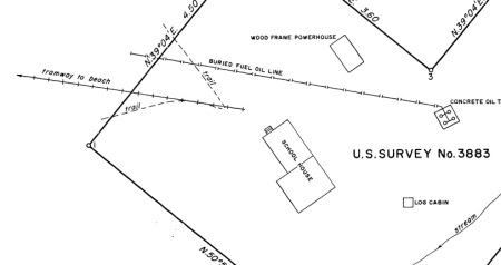
______________________________________________
Alaska Treasure Tramway
A 1.1-mile tramway ran from the Alaska Treasure adit on Douglas Island to the beach on Gastineau Channel.

Development of the mine began in 1904 and a 20-stamp mill operated from about 1906-1916. Brian Weed of Juneau’s Hidden History has an article on the mine’s history here.
Aerial photos from 1926 show a straighter tramway alignment with a Y branch at the tunnel end.

Alaska Treasure Mine 1926 Aerial photo. From Alaskan Aerial Survey Expedition Photographs, 1926 – 1979 File Unit: D1-3: 38-60 – Douglas Island
______________________________________________
Chitna-McCarthy Tramroad

For nearly a quarter-century after the abandonment of the CR&NW RR, the tracks from Chitna to McCarthy were operated as a public tram road. While the main line of the CR&NW from Cordova to Chitna was being converted to roadway, the last 60 mile “branch” retained its rails until about 1962 (The Cordova road was killed by the 1964 earthquake and later environmental lawsuits). Removal of the rails and conversion to a road likely took as long as it did due to the lack of access for heavy equipment.
After the railroad closed in 1938, residents used the McCarthy branch on an ad-hoc basis with a variety of rolling stock (mostly small hand cars, gas inspection cars, and converted autos and trucks). In 1941 the right of way was deeded to the territory as a “public tramway or tram road”, and public service was operated intermittently for many years. The Alaska Road Commission maintained the rails until WWII.
One vehicle offering public transit on the line was a 1935 Evans “Auto Railer”, a type of road/rail bus. One of these has been restored and can sometimes be found at the Alaska Museum of Transportation and Industry, and sometimes in McCarthy. A brief video of the bus in action can be seen here.

By 1947 some of the wooden bridges were already in bad condition. The bridge at Chitna had always been a seasonal structure, requiring annual rebuilding due to ice damage. After abandonment, residents could cross the river with an aerial cable tram or small boats. Tracks on the East side came down to the river bank on temporary cross ties. In the photo below a farmer is loading hay onto flat cars from a boat.

Travel to McCarthy in the 1940s-60s involved crossing the Copper river at Chitna, riding the remains of the railroad to the Kennicott River, then crossing on another makeshift aerial tram to McCarthy. Another Model T Ford pulling a variety of rolling stock provided rail transportation over the final section of track from McCarthy to the copper mill at Kennicott.
By the 1960s the track was very uneven due to melting permafrost and lack of maintenance, in some areas resembling a roller coaster. In 1962 the state awarded a contract to remove rails and ties, and planning began for a permanent Chitna Bridge in 1966. The new road and bridge were completed in 1971.
______________________________________________
Ryus Bay Tramway
A survey from 1921 shows the homestead of Leroy D. Ryus located on Duke Island. A tramway ran about 1/2 mile from Ryus Bay to (and partly across) a small lake. The property was used for farming, with a barn, silo, warehouse, greenhouse, hen house, and several workshops. The tramway was built of wood and valued at $500 on the survey notes. An article notes that Leroy and his wife Elizabeth managed a fox farm and planned a cattle ranch on the island. The tramway could have been used to haul ice from the pond in winter, or the pond could have been drained and used for farming similar to the F.H. Fielder homestead.

______________________________________________
Forrester Island Tramway
In 1941 the US military authorized a radar station at Forrester Island, near the Southern border of Southeast Alaska. Construction began that spring, with a tramway built from the dock to a high point where the radar station and support buildings were to be located. Around 20 buildings were started, but low funding and a lack of sufficient radar units halted the project. The site reverted to the Forest Service in 1946 and there is reportedly little left except foundations. The length of the tramway is not known, total distance from the camp to the dock was about 3,000ft.

______________________________________________
Fort Gibbon Tramway
Fort Gibbon near Tanana was the US Army’s Headquarters post for interior Alaska from 1899-1923. The fort had a short tramway running from the Yukon River to the Quartermaster’s Warehouse, Signal Corps warehouse, and Granary. A map of the fort can be found here.
______________________________________________
Gravina Island Tramway
The Felix H. Fielder homestead on Gravina Island featured a small homemade railway or tramway. Located across Tongass Narrows from Ketchikan, this 289 acre “truck farm” reportedly produced tons of vegetables for the local market. Fielder’s relative Diane Knutson contributed some great photos of the farm, including a homemade locomotive pulling a car full of cabbages:

This is a great photo of a classic Alaskan tramway. The engine seems to be a little hit-and-miss gas unit more commonly found running a sawmill or farm equipment. The brake lever appears to be a tree branch! Fielder may have acquired some parts from one of Ketchikan’s other tramways. The wheels on his locomotive look like the same kind of wheels seen on the Schoenbar Mine’s hand pump car.
Wooden track at Fielder’s Landing on the beach of Gravina Island. Photo courtesy of Diane Knutson:

Surveys show 1/2 mile of track running from the beach to a shallow drained lake, probably the typical Southeast Alaska muskeg swamp. The surveyor noted that Fielder’s farming method involved digging a ditch, packing it full of moss, and then covering it with soil. The drainage ditches created empty lake beds of rich loam that only needed some additional fertilizer to become a productive farm field.

______________________________________________
Jualpa Flume Tramway

The Jualpa placer mine at Juneau built a horse tram approximately 1-mile long for construction of a water flume. The flume (a sort of wooden ditch) diverted water from Gold Creek in Last Chance Basin, allowing the company to wash gravel deposits for gold. Tracks were incorporated into the floor of the flume and likely used to haul building material to complete the walls and roof. Some additional photos are here.

SONY DSC
______________________________________________
Unalga Island Tramway

Unalga Island construction camp with USS Nero at anchor. Courtesy of Alaska State Archives, John Romero Collection, PCA 342.
Several radio stations built by the US Navy featured tramways, including one at Unalga Island in the Aleutians. Built during the 1912 “Alaska Radio Expedition“, this station only lasted a few years due to its inaccessible location and poor performance.

Early beach camp and start of the Unalga wharf. Courtesy of Alaska State Archives, John Romero Collection, PCA 342.
Unalga Island has no good harbors, and the 45-man construction crew had to quickly build a wharf and access tramway to bring supplies from the ship to the station. During the 4 months of construction it was reported that the USS Nero had to leave her anchorage on six occasions to seek shelter from storms. The first wharf was destroyed two weeks after being built, and had to be replaced.

Stormy weather at Unalga wharf. Courtesy of Alaska State Archives, John Romero Collection, PCA 342.
Base camp for the facility was sited in a protected valley, with the radio antennas higher on the island’s exposed inland. The tramway ran from the wharf, through the camp, and up to the antennas. Radio equipment consisted of a 10-kw and a 3kw spark-gap transmitter, and a smaller battery unit for short range. Communication usually took place between 11pm and 4am due to favorable nighttime radio propagation.

Unalga wireless station bunkhouse and warehouse. Courtesy of Alaska State Archives, John Romero Collection, PCA 342.
Navy reports call the tramway an “industrial railroad”, and state that it had a 5HP and a 20HP stationary engine to haul cars up a nearly 19% grade with cables. It appears to have been built with prefabricated track sections like a Decauville system, but was described as “permanent”. Two cars of 2 ton capacity were used on the incline track. A more level branch line ran 1,050ft from the wharf to a gravel beach (probably where small boats were stored) and had two more cars pushed by hand. Total length of track was about 1/2 mile.

Unalga wireless station bunkhouse, tramway up hill at right, radio antenna in center distance. Courtesy of Alaska State Archives, John Romero Collection, PCA 342.
This radio facility quickly ran into trouble. The location proved to be inefficient due to nearby mountains which blocked the signal. It was also reportedly redundant, with larger transmitters at nearby Dutch Harbor and St. Paul Island able to cover the same area. Supplying the camp proved difficult due to the lack of a good harbor and the severity of weather. Storms destroyed several freight barges during construction, and the station’s 44ft motor boat was sunk less than a week after the Nero left. The permanent crew of 4 radio operators and a cook were given supplies for 2 years, as well as livestock including chickens to help them be self-sufficient. It is unclear how well the animals dealt with winter in the Aleutians.

Chicken flock at Unalga radio station. Tramway in foreground. Courtesy of Alaska State Archives, John Romero Collection, PCA 342.
The final straw came in the spring of 1915 when a fire damaged the Unalga wireless station. The Navy chose to abandon it rather than rebuild. Today you can make out the ruins of several buildings at Commodore Cove, and the faint line of the tram from the beach to the radio towers.
______________________________________________
Petersburg Wharf Tramway
A photo from July of 1919 shows the apparent remains of a wharf tramway in Petersburg. Long sections of rail lie against the side of the wharf, having seemingly been un-spiked and removed from the walkway, but not yet pulled apart and disposed of.

Courtesy of Alaska State Archives, Alaska Travel Photograph Album,1919, PCA 425-09
The wharf appears to be the Citizen’s Cooperative wharf (City Dock) in Petersburg. As with other coastal towns, a tramway would have allowed easier transport of bulk goods up and down the long approach to the deep water pier. By 1919 when the photo was taken, it may have been replaced by a truck or other vehicle.
______________________________________________
Kotzebue Tramway
A 1924 photo shows a narrow-gauge tramway at Kotzebue for transporting freight. This may have run from the town boat landing to the large hospital and school complex, about 1/2 mile.

Courtesy of Alaska State Archives, Alaska Road Commission Photograph Collection, PCA 61
______________________________________________
Coghlan Island Tramway
In the 1960s, Coghlan Island near Juneau was equipped with an aircraft radio beacon serving the Juneau airport. FAA employees mention a “substantial tramway” installed to move equipment and building materials onto the island. Rails can be found on both the East and West sides of the island in poor condition today.

______________________________________________
Dewey Lakes Tramway
Dewey Lakes near Skagway were tapped for drinking water in 1898, with a seasonal hydroelectric project added in 1902. In 1908 the system was expanded with a wood and earthen dam. Logs were sent down a flume to the dam site to build the base, then a large amount of dirt was added to finish the dam. A small tramway with mine carts hauled by mules was installed to move the dirt fill. The remains of this construction track can still be found at the dam site.

Photo by Murray Lundberg, used with permission.
More photos from Murray Lundberg of the Dewey Lake trail.
More information can be found here.
______________________________________________
Spike Island Tramway
Murry Hammond provided me with a number of photos of Spike Island’s construction tramway. This small island was located just offshore from the Cordova harbor, and had a 6″ naval gun installed during WWII. The tramway seems to have brought materials and equipment from the shore to the gun emplacement. The small flatcar was likely moved by winch on steep sections and by hand on level sections.


Photos courtesy of Murry Hammond.
______________________________________________
Japanese Occupation Tramways
Both Attu and Kiska Islands had small tramways installed by the Japanese in 1942. After capturing the islands, Japan’s military moved quickly to construct runways and other facilities, using small push carts to move dirt and fill. Photos show approximately 24″ gauge track with small flatcars that could be converted to hoppers. One photo is also labeled as showing a “drasine” (something like a small pump car or rail bicycle).
A military reconnaissance photo from Kiska Island shows “dump car tracks” going in several directions around runway construction.
On Attu, tracks from the runway tram at Holtz Bay can reportedly still be found.
______________________________________________
Payne Island Tramway
Tracks ran across Payne Island, West of Kake, for a fox farm owned by Judge Payne (his first name was apparently “Judge”). This appears to have been a large operation, active in the 1930s. The remains of several small rail cars can still be found on the island. The tramway was likely similar to that on Sail or Storm island and used to haul fish and other supplies between the beach and the fox pens.
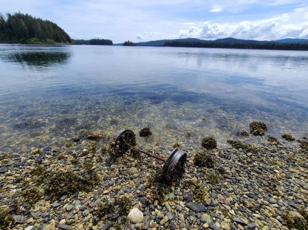
Photo courtesy of Brian Weed.
track with small flatcars that could be converted to hoppers. One photo is also labeled as showing a “drasine” (something like a small pump car or rail bicycle).
______________________________________________
Girdwood Tramway
A photo provided by Carolyn and Michael Nore shows narrow-gauge rails down the main street of Girdwood, Alaska. Founded around 1907 as a mining town, and given a boost in 1915 by Alaska Railroad construction, the town was originally on the Southwest side of the mainline tracks near the shore. After the 1964 earthquake, the original townsite dropped below high tide level and was abandoned. The photos appears to be earlier than 1920, as a photo from that year does not show the tramway. It is unclear how far the narrow gauge tracks ran, or what rolling stock was used. They could have merely run to the beach, similar to the tramway at nearby Hope, or they could have run farther up the valley to mining sites.
______________________________________________
Diamond Cannery Tramway
A horse-drawn railway or tramway apparently ran between the Diamond J and Diamond X canneries in Bristol Bay, a distance of about 3-4 miles. Several nearby canneries also had small railways to deal with shifting river courses and sandbars, but this would have been one of the longest in the area. Topo maps from the 1950s show a railroad symbol at the Coffee Creek cannery, along the road to Kvichak, which may have been the original tram route.
Although both cannery sites are now in ruins, part of the rail line may still exist. Gary Nielsen reports walking along the tracks in the early 80s.
______________________________________________
Woody Island Naval Radio Station
Established in 1911, the Navy radio station on Woody Island (near Kodiak) had a small push-tramway for freight. This was similar to other radio stations established in the same time period. This would have been the 2nd tramway on Woody Island, after the Russian ice tram from the 1850s.
______________________________________________
Swamp Point and Maple Bay Tramways
These are “borderline” tramways that was actually in British Columbia, but less than a mile from the Alaska border. The Granby Mining Co operated a limestone quarry at Swamp Point, on Portland Canal, across the mountain from their large Anyox operation. They also ran a mine and another quarry at Maple Bay. The Swamp Point quarry had about 1/2 mile of track and used a 24″ gauge gasoline locomotive. A photo of the rail dock can be found here.
The Maple Bay operation reportedly had 1 mile of track, and used a 36″ gauge gas locomotive. A photo of the “railway” can be found here.
Granby’s Anyox mine and mill had extensive railway lines and used a variety of steam, gasoline and electric locomotives. Some are shown in this photo. I have not covered it in this list since it was not in Alaska, but you can find more information here.
______________________________________________
Acknowledgements/Thanks:
The following people have been instrumental in compiling some of this information, and I greatly appreciate their time and efforts in helping me round up or clarify certain details! Where possible, I have noted sections that they’ve helped with.
Andrew Brandon
John Branson
John Combs
Patrick Durand
Duane Ericson
George Freddora
Jim Geraghty
Murry Hammond
Randy Hees
Wally Higgins
Bob King
Peggy Rich Mattson
Curvin Metzler
Dick Morris
Tom & Marge Osborne
Brian Norden
Michael & Carolyn Nore
Pat Pellet
Robert Phillips
Warren Roberts
Patricia Roppel
Stewart Sterling
Chris Sundstrom
John Taubeneck
Joseph Torregrossa
Jim & Norma Walsh
Brian Weed
Greg Yabro, Chris Wiita, and Dayle Sherba at the Alaska BLM
A few contributors have also asked to remain anonymous.
Some great websites and forums whose members have been helpful, either directly or through past posts, include:
Railway Preservation News (Main site) and the RPYN Interchange forum.
PacificNG.com and their forum.
Narrow Gauge Railroad Discussion Forum
John’s Alaska Railroad Page
Matthew Bromley’s www.railmaponline.com is a great way to see some of these railroads in map form!
All content on this page is © Gabe Emerson, unless otherwise noted. Reproduction in whole or in part without permission is not permitted. Please contact me if you’d like to use anything from this page!
Abandoned Copper River Northwestern tracks at Cordova:

..

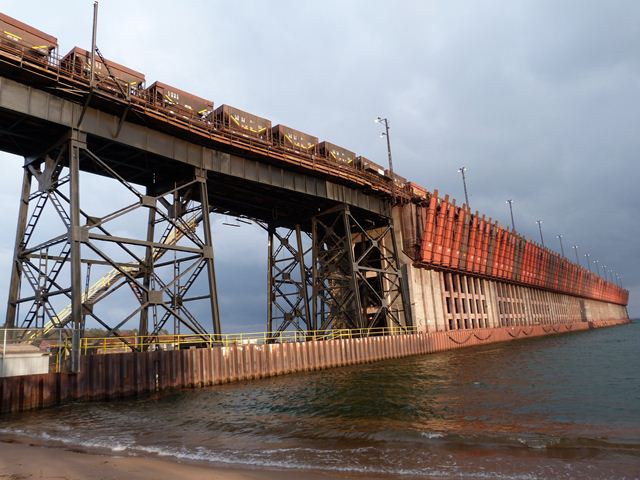
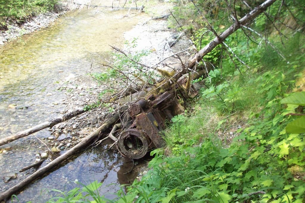
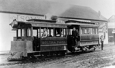
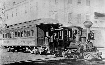
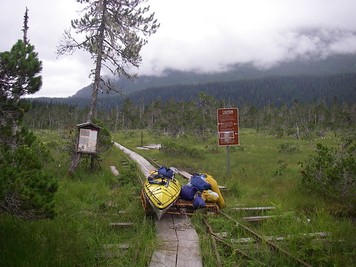
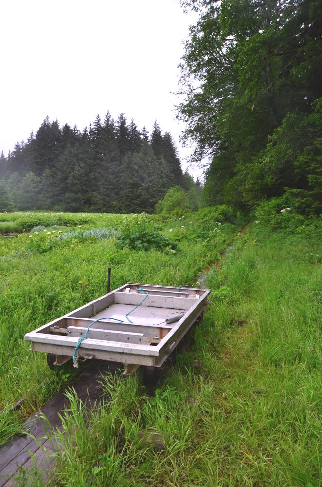
.jpeg)
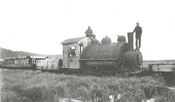
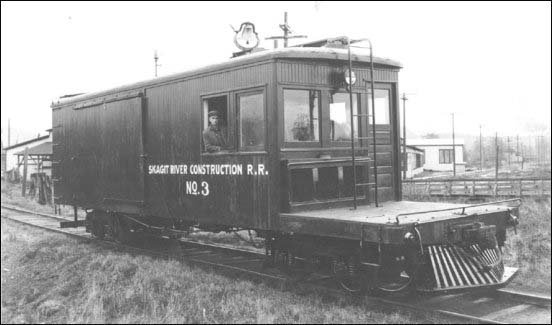
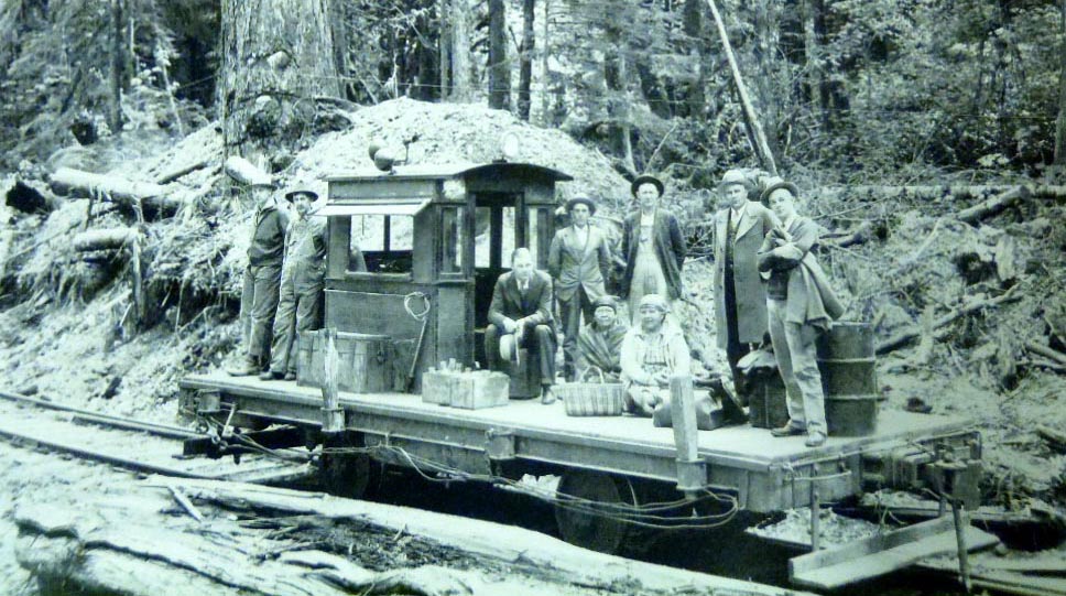
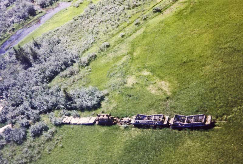
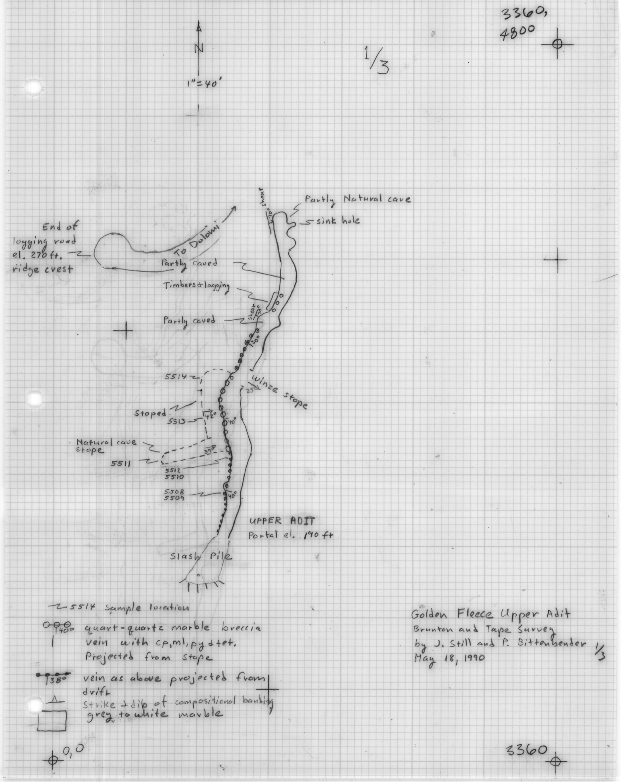
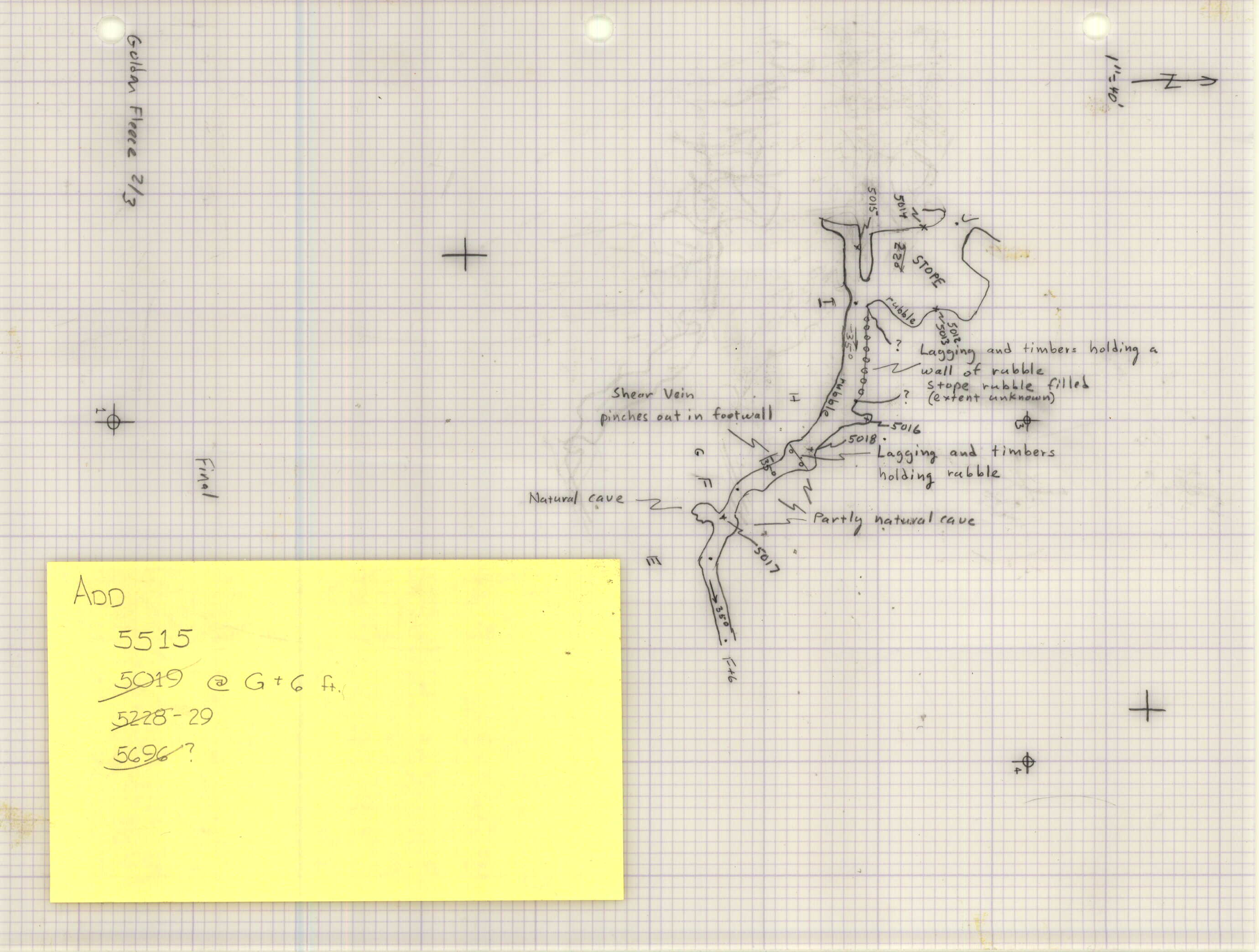
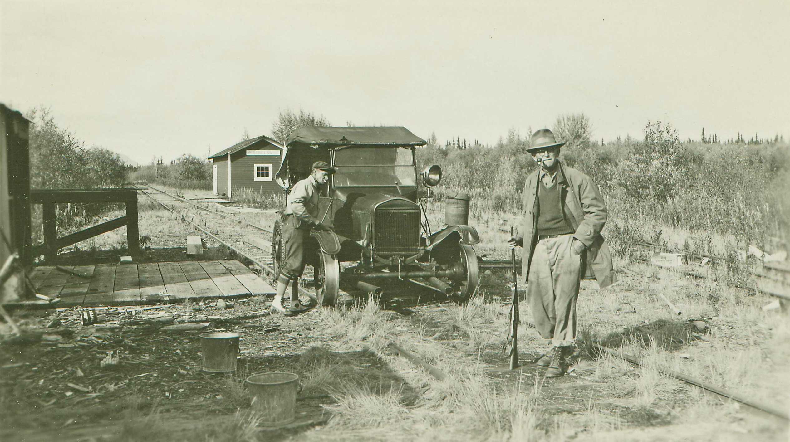
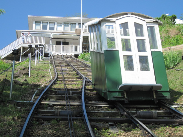
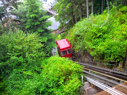
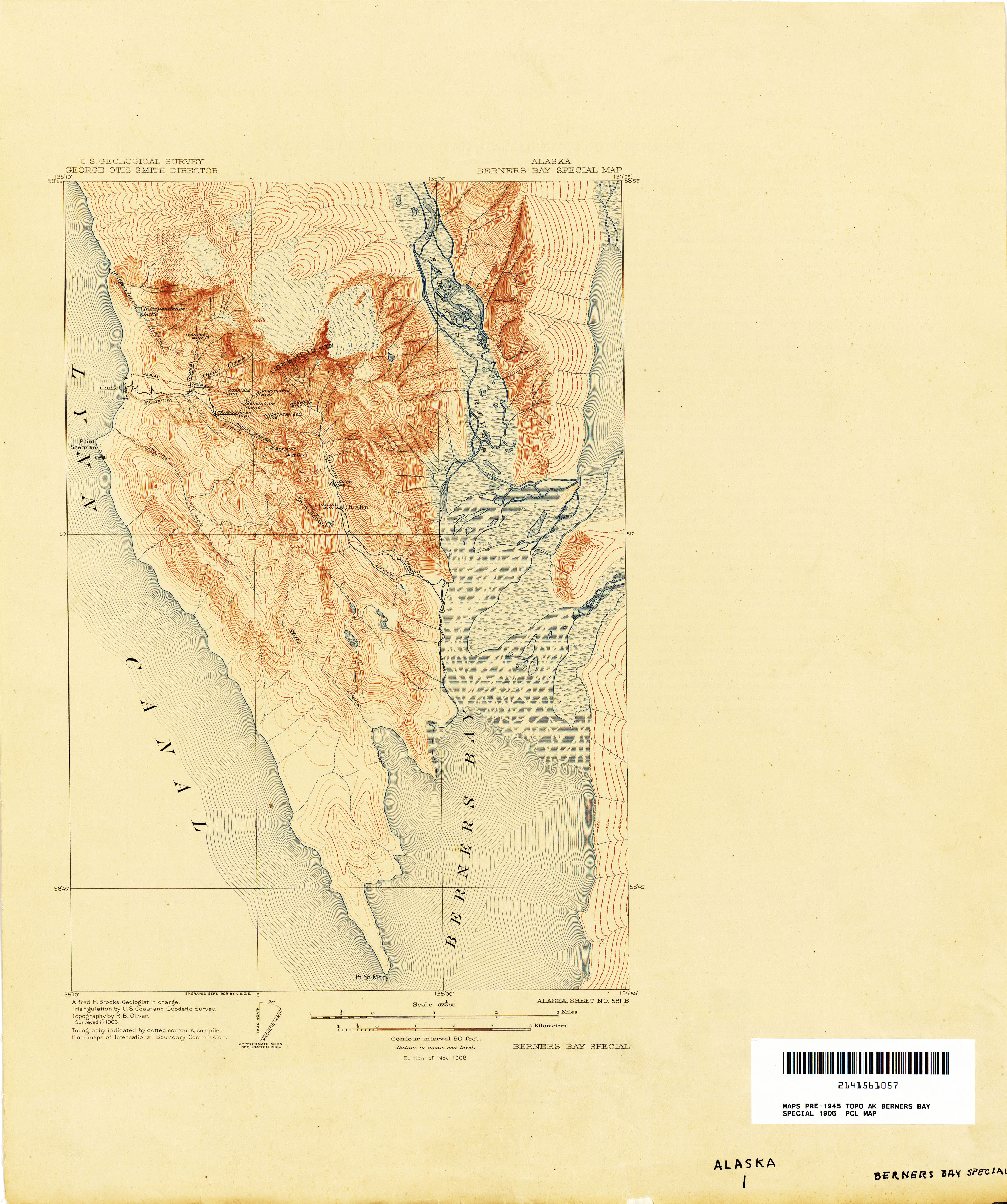
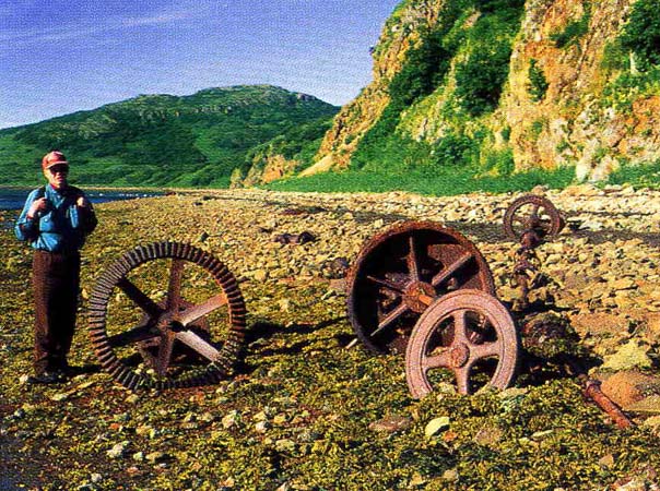
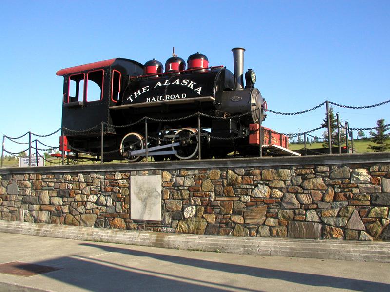
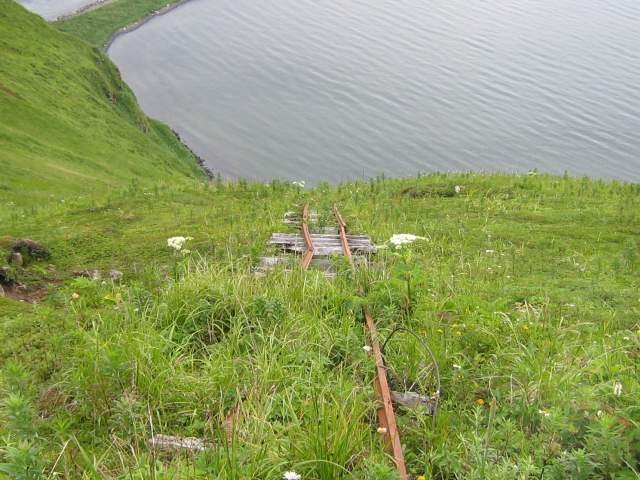
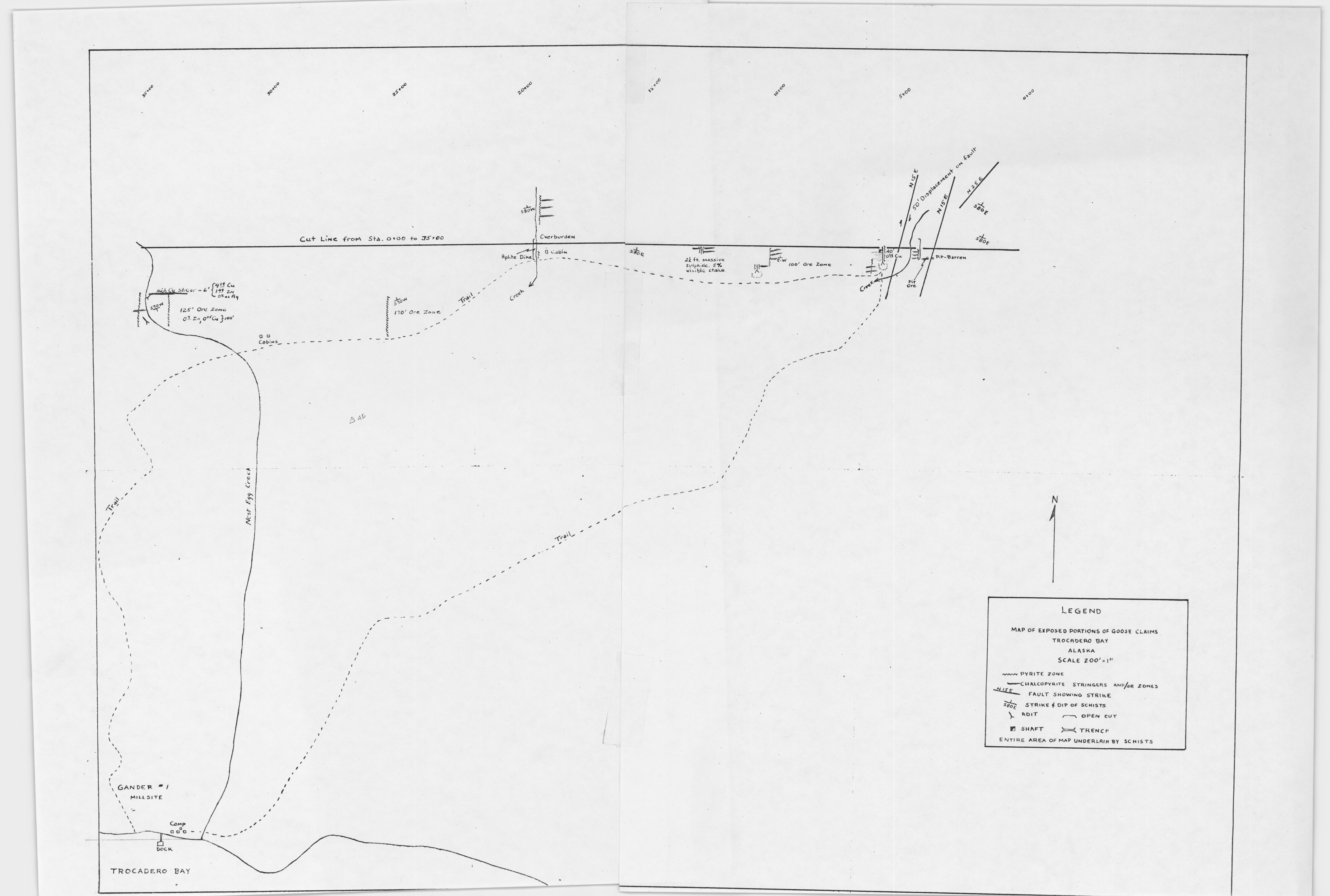
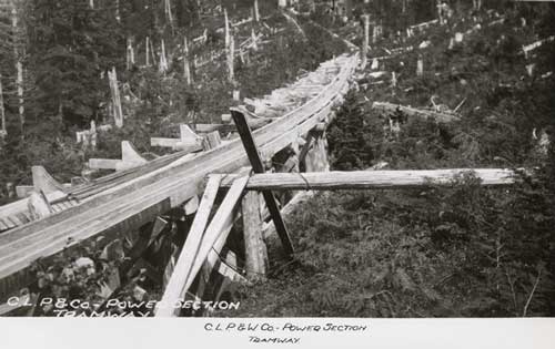
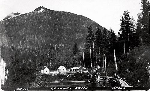
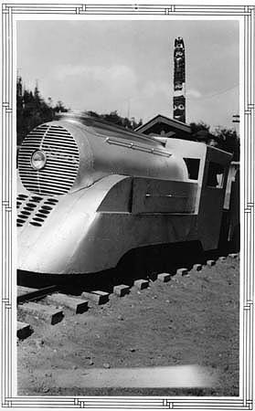
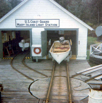
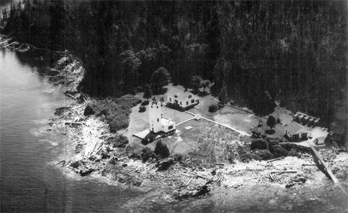
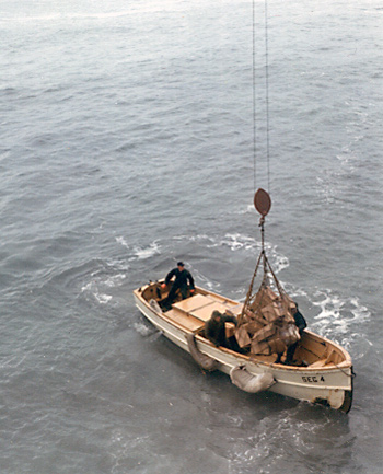
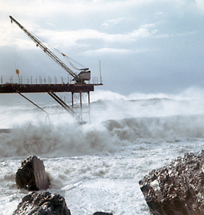
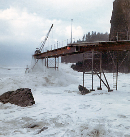
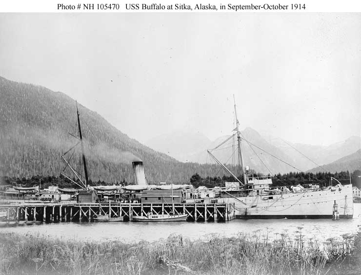
[…] https://saveitforparts.wordpress.com/projects/lesser-known-and-obscure-railroads-of-alaska/ […]
[…] Alaska was home to many small rail and tram lines in the late 19th and early 20th century. Unfortunately, many of the smaller lines are overlooked in modern lists and history books. While researching this topic I found so many forgotten and obscure railroads that I spun off a separate web page here. […]
[…] been poking at my Obscure Railroads of Alaska page a bit more. It’s fairly unorganized at this point, being mostly a running list of trams […]
[…] continuing to poke at my Obscure Railroad list occasionally (perhaps to the detriment of my Funter Bay History, which has not been updated as much […]
Hi: I have some great photos of the locomotive that came from Unga Island if you would like to post them.
Hi,
This is a great site packed with obscure information. If you would like information on the locomotives used on some of these lines contact me. I have records for Plymouth, Whitcomb, GE, Baldwin and a few others.
Yukon-Kuskokwim Portage Tram.
IN one of Constance Himericks books I think she mentions the kuskokwim -yukon tram as being old and derilict at that time, I think it was just before the start of WWII.
[…] work on my list of Alaska short line railroads has gotten me interested in toy trains again (or, excuse me, “model” trains). I […]
[…] This post examines some of the technologies, construction techniques, and equipment commonly found on small railways and tramways in Alaska (many of which I have documented here). […]
[…] other photos of rails inside or outside the cannery buildings, although some other canneries had tracks around the property for moving freight and […]
Do we really know that the Matanuska Valley coal-mine access branches were originally narrow gauge? They were standard gauge by 1950. Alaska RR operating timetable of June 3, 1951 shows the 3.8 mile Moose Creek branch, the 2.9 mile Jonesville Branch and the 0.5 mile (from Eska Jct.) Eska branch, with no indication of a gauge change, and second-class (mixed) train 22 from Anchorage went through to Jonesville, returning as train 21. My father (who was then Deputy Transportation Officer, US Armt Alaska) and I rode Anchorage-Jonesville in 1950; the passenger cars (probably just a combine) were left at Sutton, so we found footholds on one of the coal cars … easy enough going uphill, but lots of coal dust blowing off the loaded coal cars on the way down.
And the Eska photos in your link show track that looks wide enough to be standard gauge.
The description of the Yukon – Kuskokwim portage tramways is in “We Live in Alaska” by Constance Helmericks, published in 1944, in which she describes a trip from the Yukon to the Kuskokwim in 1941. From notes I made years ago from her book:
The government spent $ 60,000 to build three separate tramways, with handcars, over swamps, and put winches and cables on the cars. Smaller lakes were dredged so that the mail boat could get through from one tramway to the next. The portage route was over 100 miles long, though end-to-end direct distance was only 40 miles. There was a portage composed of rollers crossing the divide between Yukon and Kuskokwim watersheds. The first tram section had two cars; the third tram section had more than one car and was eight feet high across a marsh.
All this was built so that the mail boat could get through, and soon afterward, airplanes began carrying the mail and the tramways were used only occasionally by local people, and not maintained.
There were two railroad operations that I didn’t find on your “lesser known” website, and Howard Clifford also missed them: the military railroads serving Elmendorf AFB and Ladd AFB (which is now Fort Wainwright). In 1950, Ladd’s local railroad had diesels; Elmendorf’s had steam, which I assume was using Jonesville coal. I don’t have locomotive rosters or route maps; these were probably classified then but should be publicly available now if the files were saved somewhere.
[…] my research on Alaska’s forgotten railroads, I came across a few incidents of shipwrecked railroad cars. While such events don’t really […]
Very interesting and a valuable record.
Wow! I came across this stupendous contribution while researching the history of the Alaska Central Railway. My plan has been to build a working diorama of the railroad up to (or possibly past) the time it morphed into the Alaska Northern Railway. Yes, that includes the Loop District.
Now you have potentially complicated my plans with the enticing prospect of incorporating some of your Kenai Peninsula material into the diorama, or doing one or more separate ones. Thanks, I guess. 😉
Hey Gabe – I’ve been following you on Juneau’s Hidden History FB site and occasionally comment there. Looking at some AHL Alaska Digital Archives photos last night on-line, I came across an intriguing locomotive photo from the Agnes E. Egan photographs collection (UAF), which looks it probably was at Treadwell. UAF-1984-208-13 identifier
Here’s the URL from the Alaska Digital Archives search page: http://vilda.alaska.edu/cdm/ref/collection/cdmg11/id/35167
However, when I tried pasting it for a browser search, it came back no records found, so you might try going into the digital archives and go to that collection first and scroll down. I’m not real computer literate, so I’ll leave it to you to check it out. Nice photo worth checking out.
The caption only says “4 men and a locomotive” but it was included in my search for “Douglas Alaska” and that collection also has some definite Douglas and Treadwell photos included along with it. I don’t recognize the background building, but it still could be Treadwell, perhaps out on the main steamship wharf. What do you think? Rich Mattson
[…] recently traveled to Juneau, AK for some research on obscure Alaskan railroads. The Alaska State Library and Archives were incredibly helpful in pulling materials for me. I found […]
[…] and bunkers at Gypsum, Iyoukeen Cove, AlaskaThe old photos show a rail line and train on a long wharf leading to a large bunker in the middle of the cove. From here barges would be loaded with gypsum […]
[…] few days ago, I got a note from Gabe Emerson letting me know about his excellent website “Lesser Known and Obscure Railroads of Alaska“. What did I see in the brewery but a pair of rails from the Eldred Rock Lighthouse, used as […]
Alaska Gastineau Locomotive
On the electric locomotive currently displayed at the Alaska State Museum – the cement plant in Davenport, CA, converted from the electric railway to a conveyor belt in the mid 1980s. A private individual purchased the two electric locomotives, and later donated them to the California State Railroad Museum (CSRM) in Sacramento. In 2008 CSRM offered one of the locomotives to the Alaska State Museum, and after some consideration they accepted. As a Museum curator at CSRM I initiated and helped facilitate this transfer. I later went to Juneau to advise them on the restoration for exhibit.
Gabe…
I am researching the first locomotive that White Pass & Yukon brought in to Skagway during initial construction – a Brooks Locomotive 2-6-0 originally #2 and later renumbered #52. In a video called “Klondike Alaska: A Rail History” on YouTube it mentioned that the 0-6-0 Baldwin locomotive at the Apollo Mine on Unga Island was the first locomotive in Alaska. Your information confirms that it arrived in Alaska before the #52. Do you know if there were any others that arrived in Alaska prior to July 20, 1898? Also you mentioned that Warren Roberts is rebuilding the Apollo locomotive. By any chance is he doing that in Alaska? Thanks in advance! Keith Nore
Hi Keith, the White Pass & Yukon is often cited as having the first locomotive in Alaska. While it might be the first common carrier passenger railroad in the state, I’ve come across several other locations that seem to have operated locomotives earlier.
-Various gold mines in the Treadwell group on Douglas Island used small steam locomotives. The earliest ones were shipped there in August of 1888 and in April and June of 1889. Two more were brought in during 1896 and 1897. I’ve also seen references to compressed air locomotives at Douglas as early as 1887. These mostly ran on 25″ gauge track between the various mines and the town of Douglas. A photo of one of these locomotives from 1893 is here: https://saveitforparts.files.wordpress.com/2013/04/treadwell-0-4-0-2.jpg. The only one that might still exist is in Nevada after being used at Funter Bay, but there’s not much documentation on its age or origin.
-A coal mine at Herendeen Bay operated a “steam motor” on a 1.25-mile railroad in 1890. I believe this was probably something like a steam dummy from a lower-48 streetcar line. I don’t know what became of it.
-The Berners Bay Mining co purchased two H.K. Porter locomotives, one in 1892 and one in 1895. One is still in Alaska at the Sheep Creek mill tour in Juneau. The other is in Nevada and has been restored to operating condition. An 1894 photo is at: https://saveitforparts.files.wordpress.com/2013/07/berners-bay_new.jpg
-The Nowell family purchased a Risdon steam locomotive in 1893 and operated it at two mines near Juneau. They replaced it in July of 1897 with an H.K. Porter locomotive. I don’t know what became of the Porter. Part of the Ridson still exists and is on display at the Sheep Creek tour in Juneau. An early photo of it is here: https://saveitforparts.files.wordpress.com/2013/07/sheep-creek-locomotive.jpg
-As you mentioned, the Apollo Mine on Unga Island had a Baldwin 0-6-0 in 1897. I believe this is currently in California.
-The mines near Sumdum may have had a Porter locomotive as early as 1896, but there is very little documentation of this.
I hope that helps!
Fabulous work.
[…] few days ago, I got a note from Gabe Emerson letting me know about his excellent website “Lesser Known and Obscure Railroads of Alaska“. What did I see in the brewery but a pair of rails from the Eldred Rock Lighthouse, used as […]
[…] ↑ Gabe Emerson: Lesser Known and Obscure Railroads of Alaska. […]
[…] I was browsing through the USGS Earth Explorer website, looking for historic aerials for another project I’m working on. I came across a set of 1965 aerial photos of Funter Bay that I don’t think I’ve seen […]